jbenedet
-
Posts
7,617 -
Joined
-
Last visited
Content Type
Profiles
Blogs
Forums
American Weather
Media Demo
Store
Gallery
Everything posted by jbenedet
-
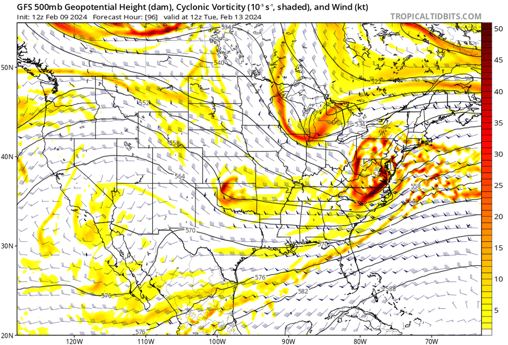
 3 days worth of catching up for the GFS, and still behind. The NAM is even worse. Be careful with them GFS clown maps in SNE; bc GFS has highest QPF.
-
Mid levels are north, but not by much 50 miles—ish. H7 goes over SE New England.
-
Eh. It bears remembering: “A butterfly flaps its wings…” small errors in the short term are amplified out in time. RE: downstream upper level heights.
-
NAM and GFS thermals continue to suck. Cold Bias beware. NAM never had breaking 40.
-
Today’s warm sector and tomorrow 60 near BOS probably have guidance and many that follow, jumping off the suppression train.
-
I don’t see suppression here; instead it’s just the trailing shortwave acting more as a kicker. If there is more phasing this comes much further north imo.
-
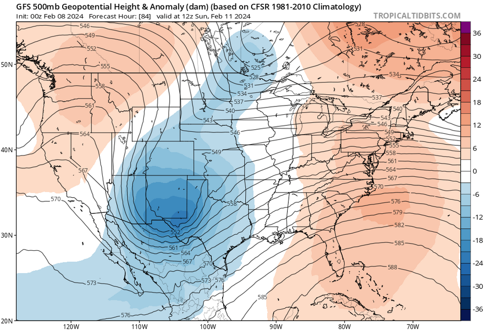
This event is lost on me so far. Still… Looking for the perceived “wall” in the northeast; I don’t see it—not at the surface, 850 or 500. Certainly not a high enough wall for potent shortwave to overcome, with long wave spacing that has the span of the CONUS to amplify…850 cold anoms are on the back side of this; not out ahead over the northeast US or SE Canada. That’s a red flag arguing against suppression. There’s also a flip flop in NAO conditions as the storm makes its closest approach, neg state to positive. Less confluence; warmer. It also means faster track. With that, I believe the 12z GFS seems like the best case scenario; snow-wise. I wouldn’t benchmark that as the most likely outcome.
-
Good call on this one. GFS was right. I was wrong. Still of course needs to verify but GFS is beating the competition through 6 innings.
-
With this I'm gonna say the GFS op is still the outlier.
-
The 12z GEFS shows a clear nod to the CMC evolution. It's much more clear in the GEFS than the op.
-
Safe to say don't really know where this goes from here. Uncertainty went up vs 18 hrs ago. Information too unreliable right now. Wait and see mode again...
-
There's still huge discrepancies just on how strong the southern stream vort is, and speed of it,, pretty early on around day 4 nevermind phasing. Kinda shocked by this, actually.
-
GFS looked more like CMC mid levels. I do think this was a shift towards other guidance, just didn't show much in the latitude gain factor in terms of sensible weather.
-
GFS is a lot slower than the EPS. It isn't at all buying an earlier phase, but a second vort in northern stream looks liable to hook up while over eastern conus. If not now, then in future runs.
-
That look on the GFS doesn't fit anything really. Not the MJO, not the teles; alone vs other guidance. Sure it could be onto something, but odds are strongly against imo.
-
That is an impossibility.
-
Triggered. and a liar. Had no idea I even made a call. lol. Not only does the guy read minds, he makes up their mind for them.
-
Pretty funny seeing these SNE weenies wanting to sell the GFS at 6z after hugging it at 0z
-
0z GEFS more phasing than the op. 18z EPS phasing > 0z GEFS 12z GFS and earlier runs were aligned with EPS and until 18z and 0z runs. I’m a seller of the flat and weak look. The 0z canadian is OTL also. Different than GFS but doesn’t make sense. I think the GFS lost the right idea from earlier today.
-
Sorry guys. 0z GEFS flaggin’ the shit out of the hang back idea of the southern stream vort.
-
0z GFS has a +NAO/+AO type evolution. Doesn’t fit.
-
0z GFS was BS the way it hangs back the southern stream and doesn’t phase at all. Hard sell. The GEFS and EPS both look more amped out west with much earlier and cleaner phasing than the op.
-
For S&G's.. 975/984 location right near PSM/PWM, is my bet at this point. And 975 good baseline in terms of intensity at that location.
-
Yeh; no kiddin'. The teles scream amped solution. This one looks like poor timing in a good longwave pattern. The Northern stream looks like it will phase early, and cleanly with the southern stream over the central US. The southern stream vort is also amped, early on out west. The building PNA ridge allows the northern stream to drop right into the central plains. Kaboom. I'm worried about warm sectoring into SE northern new england. This thing is gonna crank. Too much of a good thing, for most.