

romba
-
Posts
293 -
Joined
-
Last visited
Content Type
Profiles
Blogs
Forums
American Weather
Media Demo
Store
Gallery
Posts posted by romba
-
-
21 minutes ago, sussexcountyobs said:
FWIW Ijust saw Lee Goldberg on tv. He said theres possibility of a decent snow, but right now he's expecting just on and off snow and rain showers for Monday.
Is that SO crazy? Possibility of decent snow but likely won’t pan out at this point sounds like great advice for the masses. Us obsessives can dream about weenie snow maps
-
To my untrained eye the new CMC seems more strung out with less energy consolidation. NC gets some snow instead of it staying up around the NYC area.
0z

12z

-
-
1 hour ago, MJO812 said:
Better than 50s and 60s lol
I remember one NYE I ate outside in short sleeves with my dad on NYE.
sounds miserable
")
-
-
-
18z Euro runs around 6:50
-
1 minute ago, JoshSnow said:
Why don’t u post it what happens after that hour!
Maps stopped loading on tidbits
-
1 minute ago, psv88 said:
You see our winter storm watch? 3-10"...wtf is that
a CYA forecast special
-
RGEM Kuchera. Does Kuchera take sleet into account or treats it as 10:1?

-
8 minutes ago, NJwx85 said:
The dry slot magnified.

Wow jeezus you can get killed in some countries for making that hand gesture.
Mixing issues aside, the dry slot is hard to nail down but the models have been honing in on it and so far it doesn’t look great for the metro area.
-
-
-
Usually Kuchera shows much more ‘realistic’ totals for those marginal snow storms, but with this it shows more consistently. Is that due to potential ratios? Does it take wind into account?
-
Just now, MJO812 said:
Its the 84 hour Nam. I'm getting bashed for talking about the Nam on another forum lol
Yea let’s discuss ICON instead lol. It’s between global runs, we need SOMETHING to look at, so the NAM it is
-
Just now, MJO812 said:

LOCK HER UP....err I mean LOCK IT IN
-
 1
1
-
-
12Z
Euro:

UKIE

GFS

CMC

-
1
-
-
Just now, TriPol said:
Any word on the EURO?
About to crush

-
-
Cut those totals in half and we’re still talking about a BEAST of a storm wow
-
-
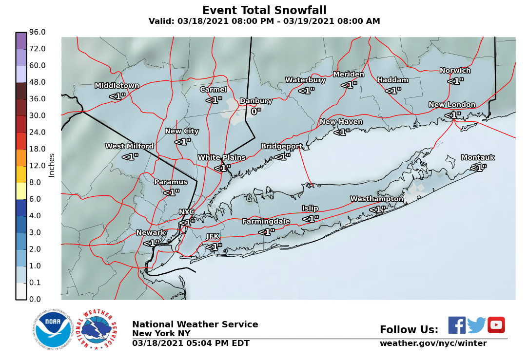
0Z Ukie showed no snow for the city, LI, and immediately N and W of the city.


-
1 hour ago, NEG NAO said:
Good Luck
 as for 12/16 event I would be concerned about much accumulating snow south of I78 - unless the EURO starts trending south - still a wide range of solutions from the wound up warm 0Z EURO OP to the 0Z very cold Canadian OP............
A blend would be really nice...
-
GGEM OP was on board for a big event until this afternoon.
-
1
-


Major Nor'easter near blizzard (6"+ most of our area-best chance 20-30" north of I78 in ne PA, nw NJ, se NYS)-ice-rain-power outage NYC subforum late Sunday Jan 31-early Tue Feb 2.
in New York City Metro
Posted
Sure, but if it doesn’t show it before 72 hours then it’s very unlikely to show it after