

romba
-
Posts
279 -
Joined
-
Last visited
Content Type
Profiles
Blogs
Forums
American Weather
Media Demo
Store
Gallery
Posts posted by romba
-
-
1 minute ago, Torch said:
The high pressure over us this weekend is not heading out. It will hang over New England long enough to keep us snow.
Could be sleet too if it stays long enough but the storm still cuts/hugs
-
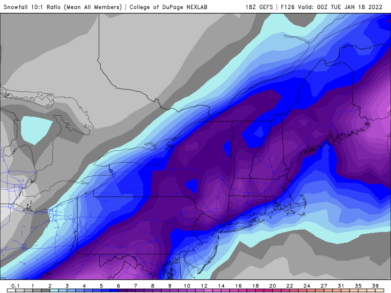
54 minutes ago, Tatamy said:
18z GEFS mean
 52 minutes ago, MJO812 said:
Difference in maps is the resolution? Algorithm? Does the bottom one show sleet as snow? Bottom seems to have been smoothed out and shows Central Jersey for example as 10-12 and top one shows it as 4-6. Pretty big difference in map totals....
-
4 minutes ago, NEG NAO said:
18Z GFS OP is off its rocker


That's 12Z snowmap.
18Z:

-
17 minutes ago, EasternLI said:
I realize some have decided that the ensembles are useless here, however I'm going to keep posting them.

.thumb.png.721d7118fd6530153fe4d1419fe5f734.png)
Thanks for posting. They seem a bit behind the operationals, but it seems that the ensemble mean is slowly shifting west as well.
-
Front end thump to heavy sleet to dry slot on Euro for just West of NYC in my neck of the woods. Close to big snows, closer to a downpour.
I'm down for a sleet storm, could use the workout (easy to say now)
On second thought, sleet plus strong winds = power outages, count me out for that.
-
9 minutes ago, Torch said:
And if this in fact comes to pass, the cold air would have to leave in a hurry, not to at least begin as snow.
Yup, we've seen it before with amped up storms.
GFS and CMC show pretty frigid temps Sunday, if the storm wraps up and takes its track it will all be for naught.
-
 1
1
-
-
I've become a pro at spotting cognitive dissonance attempts to wishcast snow. You do never know, but sometimes you gotta read the tea leaves
")
Snow Enthusiasts Defense Mechanism 101- A Course For Proper Weenie-ing, for the pros, by the pros.
When models briefly show blizzard but switch to consistently show rain (or OTS), how do you properly cope to postpone the disappointment? We have your answers right here!
-Look to the Operational if that shows snow but look to the ensembles if that shows snow. If neither shows snow anymore, please proceed to next step.
-We need to wait for the first storm to pass before models will get a real handle on our storm.
-That one model still shows a good hit.
-Storms have trended X way at Y time, as they get closer (Where X=direction for more snow and Y=time period when X trended favorably)
-Wait for better sampling.
Warning: Please implement the following only in backside of winters with minimal snowfall: Models clearly are having convective issues
In any case, the period following this storm seems pretty favorable, maybe we can get a nice storm out of it- that's the truth not a defense mechanism, I think lol
-
2
-
 4
4
-
-

Let's get some dynamic cooling for the coast peeps
-
 2
2
-
-
Go figure, GFS leading the way USA USA USA
-
1
-
1
-
-
So often that double barrel look is modelled but ends up overdone. Same with the models chasing convection like a teenage boy hitting puberty. Sometimes to our benefit sometimes not. Hopefully this is the former situation
-

Looks good for 3-5 for the city, 4-6 LI, 2-4 N&W, and 4-8 for Jersey coast.
-
Just now, EasternLI said:
00z NAM is going to be a tick west.
Yup

-
1
-
-
9 minutes ago, HVSnowLover said:
NAM still struggling with this storm, lot of run to run variation.
Looks similar to 12z, no?
-
9 minutes ago, WestBabylonWeather said:
At this point we’re pretty close to the event I guess tonight’s model runs are going to be the most important
Famous last words...
-
5 minutes ago, HVSnowLover said:
The models still a bit all over the place, 6z runs were NW, 12Z runs were SE. I think probability of at least 3 inches is pretty good right for immediate tri state area but probably have a better idea of jackpot zone by 0Z tonight or tomorrow.
sure, but I'd obviously rather the all over the place = better runs now when they're honing in on the trajectory, versus better on previous cycles
-
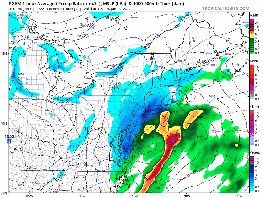
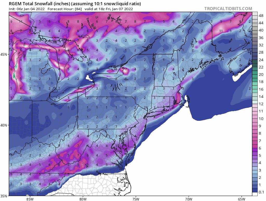
RGEM south, scrapes NYC. Not getting my hopes up for more than a couple of inches.

-
1
-
-
1 minute ago, mikem81 said:
GFS and CMS SE of last runs...
Midatlantic, Eastern LI and SENE seem to do well on latest GFS, not bad for the NYC area

-
Nam coming in weaker and South so far....
12z:

6z:

-
1
-
-
1 minute ago, SnoSki14 said:
At this point I'll take an inch hell even a dusting would work
plowable snow or 70's for me
-
2
-
-
1 hour ago, NutleyBlizzard said:
Snow maps please.
we never learn
-
1
-
 1
1
-
2
-
-
Ukie looks way flatter for Friday, hard to tell how it progressed on the 24 hr panels though. Flatter/OTS seems to be the way that storm is trending with the GFS leading the way, lots of time for changes though.
-
Last 3 runs of the CMC, trending more progressive/off the coast
.thumb.gif.6f731e99794823a80f6ee2757dfe27e9.gif)
-
11 minutes ago, Stormlover74 said:
Ouch
.gif.bea94606b830fbf9849e8648dfac63f5.gif)
Painful for some, we've all been there.
-
13 minutes ago, MJO812 said:

That’s the upgraded GFS hi res- how’s it performed this season? The regular GFS is upgraded already to the FV3, wonder why the hi res/NAM hasn’t been moved over yet.
-
1
-

.png.65321647b296331cce9e5bf142690dc1.png)

.gif.78c317f9bf3a5a9cf93d764d4864e4f7.gif)

East coast storm targets our subforum Noon Sunday-3PM Monday 1/16-17/22 with significant impact potential for heavy snow/heavy rain, a period of gusts 45-60 MPH along the coast with possible coastal flooding Monday morning high tide.
in New York City Metro
Posted
Look at that difference between EPS and GEFS! EPS seems to have caved to the operationals, though the 6Z GFS made a first move towards the GEFS. A blip? Was the new recon data ingested for 6Z?
GEFS showing quite a number of unphased OTS progressive versions, wouldn't that be something!