

romba
-
Posts
279 -
Joined
-
Last visited
Content Type
Profiles
Blogs
Forums
American Weather
Media Demo
Store
Gallery
Posts posted by romba
-
-
29 minutes ago, wishcast_hater said:
For us guys near 84.
Cool cool, Russia is now part of this forum
")
-
 3
3
-
-
4 minutes ago, Doorman said:
OPC 72 hr surface prog

stationary front - n&w gets dicey

WPC not buying the ice potential yet?
-
Looks beautiful out, moderate snow getting close to an inch (eyeballing) 3 miles west of the GWB
-
 1
1
-
-
2 minutes ago, Snowlover11 said:
what a ****ing headache. the fact we are hours away from this and we still have alot of uncertainty is mind blowing.
It's getting clearer, just not how some of us want it to be....
-
I'll be happy enough with 5+inches at this point, enough for the kids to go sledding and have fun on Sunday. Anything more is gravy (Thanksgiving style, the good stuff)
-
1
-
-
Less wind here = better ratios and hopefully power staying on
-
4 minutes ago, NJwx85 said:
We're inside 24hrs. The Western and Eastern most outliers are coming together for the likely outcome. We still have a small shot at a substantial shift in either direction tonight.
Yup, the double barrel feature might be legit at this point.
Just not certain why they're sending more aircraft recon for tonight's 0Z runs so late in the game....
-
6Z NAM EVERYBODY'S COMING WEST BABY followed by 12 Z suite maybe not
-
5
-
-
1 minute ago, weathermedic said:
Air recon supposed to take place in the Pacific later today. Don't know if that data will get ingested in time for the 12Z Euro/GFS suite.
Read on here it’s supposed to be ingested for tonight’s 0z suite
-
1 minute ago, Blizzard-on-GFS said:
Yes, the run just started he’s a troll
It’s out already on pivotal and for sure the French site, and looks east to me fwiw
-
I’m hesitant to put much weight on the mesos at the end of their runs so it’s rn only the Euro showing NYC proper getting the goods. The globals, aside from the Euro, seem to be showing the surface low just east of the BM, we want that a little more tucked but I’d still think the precip shield would be a teensy bit more expansive without suppression pushing down. Euro on an island despite some west trends, I expect it to tick a little east to start to meet its buddies somewhere in the middle.
-
2 minutes ago, eduggs said:
The JMA is nearly identical to the CMC. It lacks the resolution to show the true lowest pressure, but it's a close match aloft. And it actually lingers a little longer as it moves northeast off the Cape. Huge hit for LI and CT at least.
Everyone will say it's just the JMA, but I'll take it. The more support the better. Eventually we need every model to come around.
JMA supported the Euro for a bit when it was on an island too, NAVGEM jumped aboard too if I recall, better than nothing but barely lol
-
H5 Monster for next weekend.
I’ll say this, I’d rather have the op GFS in my camp than the Euro, though Euro shows a storm too at least, crazy times we’re living in
-
10 minutes ago, Franklin0529 said:
Ensembles ensembles ensembles
Except for this winter, smart money this year is unfortunately on the 'no snow' progs. As we saw a couple of weeks back, all the ensembles at 5-7 days, their $ range, were like SNOWWWW BOYYSSSSSS and the OPs, which are supposedly weaker that far out, all said to ef off. Guess who won
")
-
2
-
-
12 minutes ago, White Gorilla said:
I took the CMC on a date, and I'm sleeping with the EC. Will not marry either.
-
1
-
2
-
-
GFS continues to show surface low popping in a good spot southeast of the city, unfortunately the mid and upper levels seem locked in as west, west and west. They haven't budged in like 36 hours so no go with this one. Was fun to track and learn
-
Slight improvements on the Euro at 500 and the surface, but still too way too far west for the city/coast.
-
7 minutes ago, jm1220 said:
Exactly. If we keep this cold pattern and +PNA there will be more chances in the future. As others pointed out and I said yesterday, if the mid level lows go west of you there won’t be much snow for you. Maybe sleet inland but it would be quick snow to rain on the coast if that. You want those tracking east of you if you’re hoping for snow. Any run that shows them west of you is bad news.
So ideally 500, 700, 850 lows should track East for snow. Does surface lp matter or not really?
-
6 minutes ago, eduggs said:
From the GEFS I would interpret a high likelihood of the captured primary SLP moving into NMD or SEPA. A second relative min. surface reflection is also likely to develop south of LI. I think that's why we see a few Ls there on the ensemble chart. But I don't think that means that the entire storm is shifted east in those cases. If two areas of low pressure are of approximately equal pressure, they may alternate on which is the absolute lowest. The L only gets placed at the point of lowest pressure. That could explain some of the Ls south of LI. It doesn't mean those storms are shifted 80 miles east. It might just mean that in those cases, the inland SLP occluded a little sooner and weakened slightly.
The models like hedging their bets with the multiple lows farther out and tend to hone more on one low as it gets closer, didn't that happen with the last storm?
-
6 minutes ago, Rjay said:
Thank you for being the voice of reason while I'm working.
I don't know enough to comment myself, but a pro right beneath him said that it was a pretty dramatic shift east implying it does matter....
-
1
-
-
-
14 minutes ago, jfklganyc said:
We haven’t had a winter in a long time where we have cold that lasts more than a few weeks before an extended warm up.
If you’re talking about a favorable pattern that produces snow in warm conditions…great. but if you think this seasonably cold or below normal air is going to stick around indefinitely, I doubt it.
I would like to see us capitalize on some of this while we have it.
No way to sugarcoat this… if this cuts West this is a big hit
Love that, 40-50's, dare I say 60's, followed by a perfect track Miller A that produces it's own cold air and get to enjoy the snow for a few days before back unseasonably warm.
Watching the temp drop from upper 50's or low 60's to mid 30's as storm time starts, and then down to low 30's as it really gets ripping is great.
As opposed to the oncoming one where we'll most likely be watching it go from teens/20's to low 40's
-
8 minutes ago, ILoveWinter said:
Typically with this sort of lead time, we tend to focus on the ensembles. Is there a reason we are more trusting of the Op runs this time around? Is it due to their consistency with showing the interior/inland track?
I think the general agreement of the operationals lends weight to them. The complicated synoptic setup apparently also gives the ensembles more difficulty, though what big storm isn't a complicated setup?
-
5 minutes ago, jm1220 said:
Pretty straightforward for us actually. This strongly favors a rain event for people near the coast and a mix or mix to rain inland. We need for the Op runs to be a huge error at this point or a major trend east starting today. It’s unfortunate but it’s what it is.
That's the truth. Fun to track and hope but need to be level headed.
I remember about 4-5 years ago the models were showing low over the lakes acting as a kicker for our potential storm. Close, but OTS about 100 miles too soon run after run. Then, just as the clock was running down, when all hope was lost (except for mjo/snow88 of course), an aircraft recon ingest at about 84 hours before the storm revealed the lakes low not to be a kicker but to actually slide under and push our storm north, and we ended up with a foot+. That was exciting to track!
-
1
-


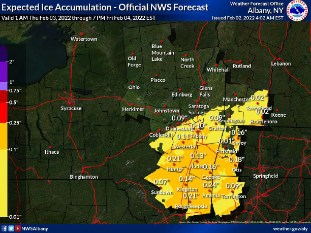
February 3-4 significant icing event for the interior, some sleet/snow possible. Coast mostly rain.
in New York City Metro
Posted
Not windy during Octosnow but heavy wet stuff on trees with leaves led to many broken limbs and branches. I drove home Saturday night from Hackensack and it was an obstacle course on the side streets with downed trees and wires. Once you hit the city- nada