amt5626
-
Posts
50 -
Joined
-
Last visited
About amt5626

Recent Profile Visitors
1,516 profile views


-
Let’s talk winter!! Ohio and surrounding states!!
amt5626 replied to Steve's topic in Lakes/Ohio Valley
Holding out hope out here near Toledo. I really like what the GFS is showing last couple runs. Euro probably too strong with the low. Will be interesting to see the 12z EPS. I was surprised to see the Euro double down at 12z. This winter has been pretty boring so far, but I am at least thankful to be tracking again. It's so hard to get the right track with enough cold air in place. At least the lake effect should be great on the backend of the storm for those in the snow belt. -
Liking where I'm at in Perrysburg for the mid-week storm. Feel comfortable saying we get 5-8" here. Seems like good consensus on timing in the guidance. Amounts a bit more variable but seems good enough for WSWs to eventually go out.
-
Can't say an Enhanced Outlook over Ohio was on my Winter Bingo Card this season.
-
Eh, it's time to give up on winter and move on to the start of severe weather season tomorrow.
-
Thinking I ride this out in Toledo tonight. Might head back to CLE if it looks like best parameters favor a bit further east. First real severe threat I've been in for quite some time. Storms over Indiana now. CAMs failed there in the short range.
-
I would just head that way to visit my parents if the trends continue, but my roommate tested positive for Covid yesterday. So out of caution will be staying in Toledo for a bit. I have a hard time believing the super far south solutions. We can afford a bit more eastern movement/pressing of the high before we start to lose out on the second round Thursday. Seems to be a case of Euro/CMC vs. GFS/NAM/UK. Either way, still going to get WSW criteria snows it looks like.
-
Back at my apartment in Toledo for this one. Should be a great event here. Depending on how Thursday's snow shapes up, could be really something special. 12" looks to be a lock for now.
-
HRRR completely missing the band over us right now. With that said, it still manages to give decent snows up this way. Feeling pretty good!!
-
Love to see the HREF giving 6+ here. Feeling comfortable for a solid 6-8". And too funny that you used to be in HKT! I plan on moving out that way sometime in the spring/summer to start more of a hybrid work environment. Will miss the virtual work and Ohio life some, but always open to new exploring new places.
-
Greetings everyone. Haven't posted in some time due to a combination of starting a new job in the Fall working as the lead meteorologist for Mars Inc. (a very sweet job you could say), as well as there not being too much local weather to talk about so far this winter. It finally looks like there is some excitement going around in the sub leading up to this storm. No matter what happens, definitely happy to at least be able to track something again. With that said, 18z Euro looks great for us with over an inch of QPF for downtown CLE, but I am still concerned that we will be just a touch too far west here in Cuyahoga county. Nonetheless, I do think at least Winter Weather Advisories are now needed here based on all the guidance I've seen today. I would argue winter storm warnings may be in order too. But there is time to see what the 0z guidance shows tonight. Would want headlines out by tomorrow afternoon before the snow starts falling. Hoping everyone is able to cash in with this storm. Worried that once we get to February, assuming dynamical models are to be trusted and La Nina continues to dominate, we may torch rest of met winter. Was surprised by the icy roads last night. Saw a tow truck sliding backwards down a hill on the way back home from the gym. Yikes!
-
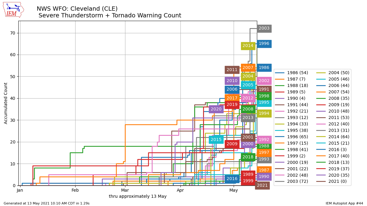
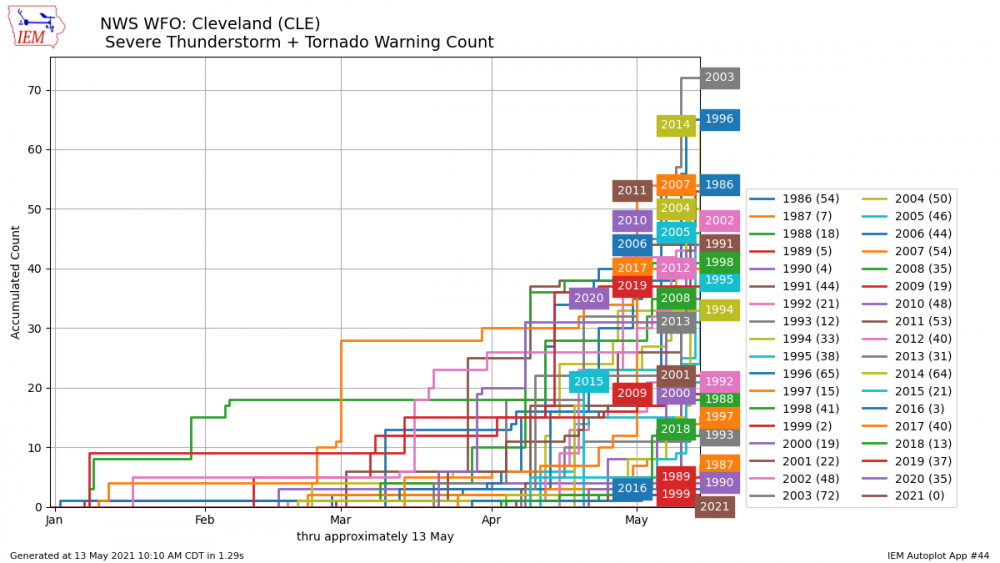
NWS CLE sitting nicely at 0 SVR/TOR warnings this year so far with no sign of any major storm threats through the end of next week. This has honestly been one of the least exciting stretches of spring I can recall. At least it is finally starting to warm up to more seasonable levels.
-
NWS point forecast has me at 3–5". Really impressive if we hit toward the upper end of that. But I want no part in any of this late season snow. So long as those Alaskan and Greenland ridges remain through the rest of month, there won't be any major warmups. Things look to turn warm again as we head into the first week of May as both those features give way. I feel pretty confident that this should be our last accumulating snow and most likely the last flakes of the year for most/all here in N OH.
-
Recently got an apartment over in Perrysburg, OH to complete the rest of the "work from home" phase this year while living with one of my old high school friends. Seems like this storm trended a bit NW here to follow me back west . Feeling pretty good about 10–12" here across much of NW Ohio. Will easily be some local totals over a foot. Excited to see how the ratios pan out. Only 16° at TDZ right now, 20 at CLE. I wouldn't be worried about the HRRR showing mixing that far north back in NE Ohio.
-
I am beyond thankful for our two big December storms. This current system was never promising, but I'll admit I spent a fair amount of time tracking it (not much else to track this past month). I much prefer warmth over cold to be honest, and am always anxious for hints of spring weather by the time mid-to-late February arrives. However, this looks to be my last year up north before moving to Atlanta early next year (was going to do that last year but decided to wait until Covid settled down). I had actually already said "goodbye" to winter as I knew it last year when I spent what I thought was my last full cold season experience in Albany, NY, where I was finishing up my M.S. degree requirements/thesis. We only received one noteworthy storm that year (recorded just under 2' over a couple days to start off December; the snow intensity over the entire duration was remarkable). Found it rather funny they ended up beating that storm's total in less than a day this winter. If the December storms are all we get, I'll liken them to my final storm in Albany in that I'll have great, last winter memories of living full time up north for the foreseeable future.
-
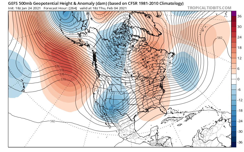
I've enjoyed the light coating of snow that has managed to stick around the last few days. I am not surprised at all with how the early week system trended (north, warm, and dry) and with how the following storm is going to pan out (sheared out and south). Things are likely to continue looking not good as we head deeper into February and the SE ridge eventually sets into place. CPC favors warmth for the entire Midwest and East during the 6–10 and 10–14 day periods, and I would have to agree with that at this point. Euro weeklies also show these warm anomalies for the next few weeks. With Lake Erie still being mostly ice free, I could see a decent lake effect event for the secondary snow belt at some point before winter "ends," but I am starting to think we used up all our winter magic last month. It really is a shame that with so much blocking, the Pacific side continues to fail to cooperate. Recent GEFS runs paint the picture for what the remainder of meteorological winter may look like.