CAPE
-
Posts
36,279 -
Joined
-
Last visited
Content Type
Profiles
Blogs
Forums
American Weather
Media Demo
Store
Gallery
Everything posted by CAPE
-
88/74 approaching 10 am Sultry.
-
Just had a brief shower roll through. Wind kicked up a bit. Not what I was expecting today, but no complaints. The high will be 87, and that occurred around noon. 83 now.
-
Breezy here now too. Makes a difference in comfort level with the clouds in place.
-
Temp down to 84. Would be cool(literally) to get a shower, but they are weakening as they cross in into DE. One thing is for sure- the forecast didn't account for the impact of the clouds and the expected high of 94 is a bust.
-
86 at 230. Clouds helping to keep the temp down but still pretty uncomfortable out there with the humidity and no breeze- unless you are sitting or standing still.
-
87 at the noon hour with filtered sun from clouds associated with the storm complex to the north.
-
Drinking one of these. Summery beer. Lots of tropical notes. Pineapple and coconut are prominent. Well done for what it is. One is enough for me.
-
High of 88. Currently 86. If there was a breeze it would feel pretty nice out there. Tolerable as is.
-
86 just after 2pm. Not sure its going to make it to 90 today.
-
87 at noon. Forecast high is 92.
-
Unfortunately that process has already begun. It's inevitable. I'm going to try white clover and wildflowers in that area for next year. Everywhere else is pretty much mossed over. In the Spring I planted a patch of wildflowers in the back along the edge of the woods and they are doing pretty well.
-
Forecast high of 98 here on Monday. I'll take the under. 98 is the highest temp I have ever recorded here, and it was once or twice. It will end up 95-96 maybe.
-
78/59 with a nice breeze. Fantastic. Heading out to do some yardwork before the heat dome arrives.
-
Super nice morning. 65 and breezy. One nice day before the heat and humidity cranks up.
-
Up to 0.62" for the day and just over an inch since yesterday. Still some light rain to come through. Pretty respectable given all the misses this month.
-
Another line of storms firing just to the west. Can hear the thunder. Still looks like it will mostly slide to the NW. At some point a direct hit has to happen, right? Lol its been uncanny this month.
-
Solstice tomorrow. Positive thought as we head into a blistering hot and dry period- Shorter days ahead as we work our way back towards winter. Can't wait for Fall and football.
-
Completely underwhelming yet again. 0.31" and a few rumbles of thunder. Maybe I can nickel and dime my way to half of normal rainfall for the month lol, although not much chance of anything over the 7 days. Currently at 1.6". After baking for a week it will be desert-like here by next weekend
-
Drove through Ridgely(along Rt 480) on my way to work and there was some significant damage to several larger trees and plenty of other tree debris scattered around. That's a little south of the Mesonet station. My guess is winds probably gusted 60+ in that area.
-
Training camp starts in a month. Can't come soon enough.
-
Putrid loss by the Orioles after being up 8-0. 12 unanswered runs? Pathetic. This team isn't to be taken seriously, and should be sellers.
-
Ravens sign CB Jaire Alexander after Pro Bowler's release from Packers https://www.nfl.com/news/jaire-alexander-ravens-sign-cb-pro-bowler-packers Excellent move imo. Former college teammate of Lamar Jackson, who has been lobbying to sign him. As we all know, you can never have too much depth at CB. Ravens especially know this.
-
0.43" Eh, better than a complete miss. Really could use a 1"+ deluge.
-
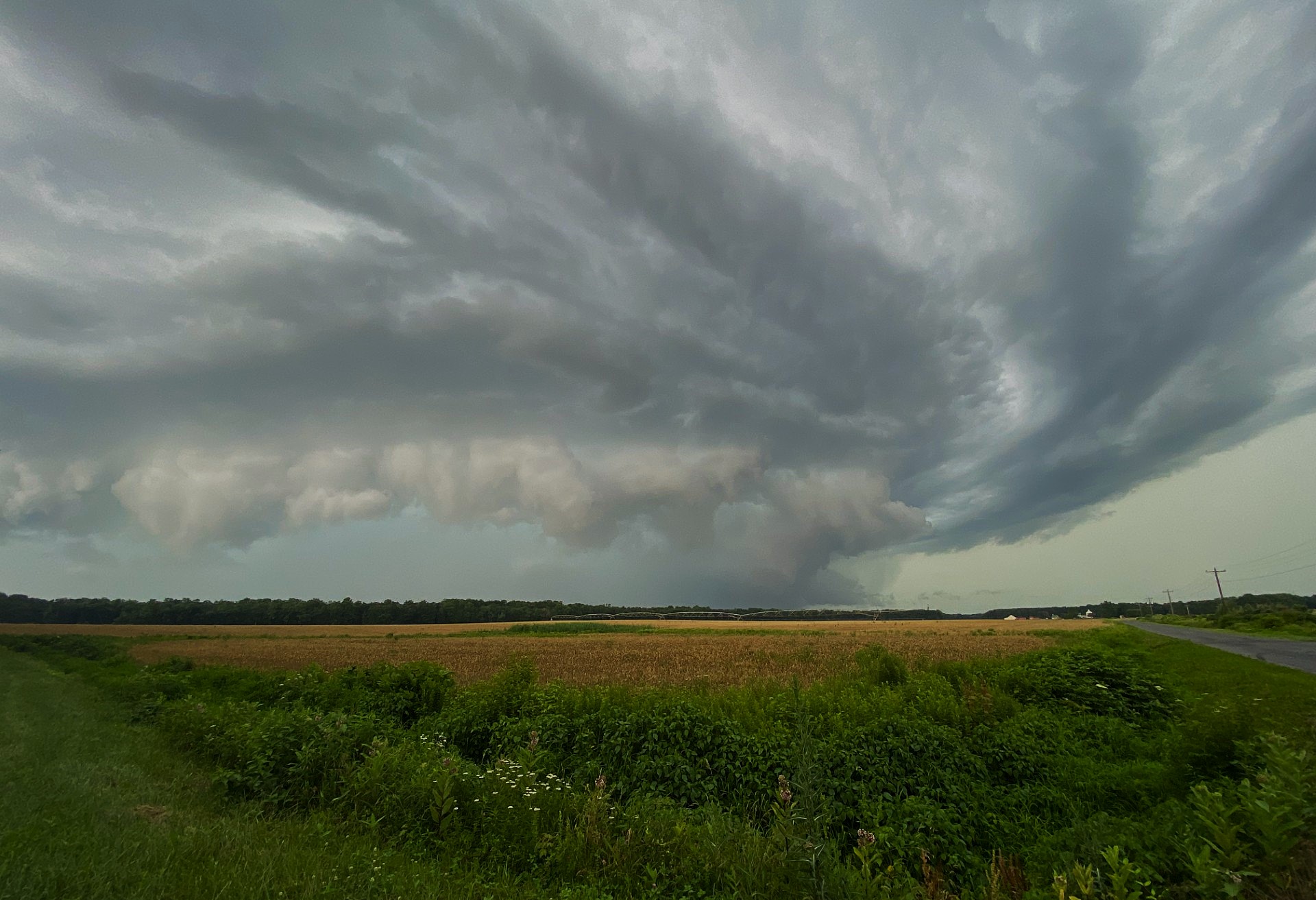
Looked like some rotation when I was watching it roll in. I post a pic in a bit.