40/70 Benchmark
-
Posts
77,973 -
Joined
-
Last visited
Content Type
Profiles
Blogs
Forums
American Weather
Media Demo
Store
Gallery
Everything posted by 40/70 Benchmark
-
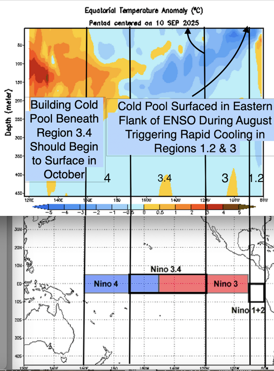
Yes, I think Jerry is focusing on region 3...while 1.2 is volatile....this marked cooling in that zone isn't a function of volatility. If you have been paying attention, the subsurface cold pool emerged due to sustained trades.
-
No; it invalidates it. The eastern zone of 1.2 began warm and the subsurface cold pool emerged there.
-
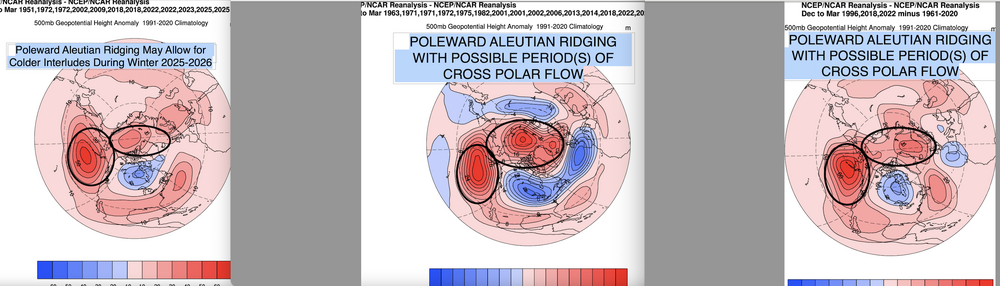
I think that is a larger problem in December..not so much late season.
-
I think you have it backwards accordingly to the weeklies,,,eastern zones recently caugt up-this is supported by JAMESTEC EMI data. East-to-west 23JUL2025 22.2 0.6 25.5-0.1 27.0-0.2 28.7-0.1 30JUL2025 21.8 0.4 25.3-0.2 26.7-0.3 28.6-0.1 06AUG2025 21.9 0.8 25.2-0.1 26.7-0.3 28.7 0.0 13AUG2025 21.6 0.6 25.2 0.0 26.6-0.3 28.6-0.1 20AUG2025 20.8-0.1 24.7-0.3 26.4-0.4 28.6-0.1 27AUG2025 20.5-0.3 24.3-0.6 26.3-0.4 28.5-0.2 03SEP2025 20.5-0.2 24.5-0.4 26.4-0.3 28.5-0.2 10SEP2025 20.5-0.2 24.4-0.5 26.2-0.5 28.3-0.3
-

2025-2026 ENSO
40/70 Benchmark replied to 40/70 Benchmark's topic in Weather Forecasting and Discussion
Maybe a hair stronger than last year- -
2025-2026 ENSO
40/70 Benchmark replied to 40/70 Benchmark's topic in Weather Forecasting and Discussion
We need the trades colocated with the subsurface cold pool...we had that big time througout much of August, when we had the burst of intensification of La Nina due to the upwelling of the cold pool over the eastern half of ENSO. However, trades died down and shifted west in Septmeber. They look to pick up out east again next week and into October, but not as strongly as August. SOI has also been inching upwards. I think at the end of the day, the pedestrian coupling of the trades with the cold pool, owed at least in part to the diffuse PAC pressure dipole (Low west/high east) is what will have this La Nina struggling to be acknowledged by CPC in the record books. Will be very close. The subsurface says game on...but the hemisphere isn't totally on board.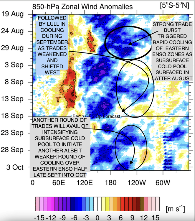
-
2025-2026 ENSO
40/70 Benchmark replied to 40/70 Benchmark's topic in Weather Forecasting and Discussion
IRI plume def. more aggressive with La Nina. I think they have finally caught onto to an event that will will fall just shy of official designation. I called -0.5 to -0.7 ONI peak back in July and it looks like dynamical guidance now peaks at -0.71, statistical -0.53 and mean of all guidance -0.61. https://easternmassweather.blogspot.com/2025/07/la-neutral-enso-conditions-will.html Will probably go onto to overcorrect a bit next month, too before tickling back later in the fall. Subsurface is quite stout, but I don't think we will have the trade clout to surface as much of that in region 3.4 as we did in 3 and 1.2. -
2025-2026 ENSO
40/70 Benchmark replied to 40/70 Benchmark's topic in Weather Forecasting and Discussion
Yea, well don't forget the E QBO. This shouldn't be a super nova +NAO that is devoid of blocking. -
2025-2026 ENSO
40/70 Benchmark replied to 40/70 Benchmark's topic in Weather Forecasting and Discussion
I would go north of Tahoe this season. -
2025-2026 ENSO
40/70 Benchmark replied to 40/70 Benchmark's topic in Weather Forecasting and Discussion
My extra tropical Pacific composite actually looks just about identical to that BAM Atlantic composite. Primary Extratropical Pacific Analogs: 1971-1972, 2017-2018, 2021-2022, 2024-2025 -
2025-2026 ENSO
40/70 Benchmark replied to 40/70 Benchmark's topic in Weather Forecasting and Discussion
Given the embryonic nature of this cool ENSO event, I'm not sure the -IOD is really going to couple with it enough to be a huge deal....bottom line is I would expect a weak La Nina response...this shouldn't be 2022-2023. However, I think the development of the -IOD does ensure that this will indeed be a cool ENSO season, and that the WPO is likely to be at least somewhat positive....two things that I had already been assuming. -
2025-2026 ENSO
40/70 Benchmark replied to 40/70 Benchmark's topic in Weather Forecasting and Discussion
Looks similar, but I'm a bit more aggressive with some episode(s) of blocking per the easterly QBO/solar max composite. -
2025-2026 ENSO
40/70 Benchmark replied to 40/70 Benchmark's topic in Weather Forecasting and Discussion
-
2025-2026 ENSO
40/70 Benchmark replied to 40/70 Benchmark's topic in Weather Forecasting and Discussion
The real heart to the drought is over northern New England....couple that with a modest +NAO and maybe its finally my turn. -
2025-2026 ENSO
40/70 Benchmark replied to 40/70 Benchmark's topic in Weather Forecasting and Discussion
Anyone know why this IOD link isn't updating, and where the updated numbers are? https://psl.noaa.gov/gcos_wgsp/Timeseries/Data/dmi.had.long.data -
Not one tropical post on my blog...first year that has happened since I started it in 2015. Erin was always a non-threat in my mind, so didn't see fit....if I had more time I probably would have made a post detailing why I was dismissing it early on, but that's it.
-
I was thinking yesterday how 2025 is the most boring weather year of my life. Absolutely dong for notable weather....nothing. Incrediable quiescence in the tropics....no notable snow events. Unless we have a good December, this is the most boring year by far. 1991 had Bob....1990 had the March ice storm....1989 had the Thanks Giggity (Hi, Tip) snowstorm.....maybe 1988 could challenge? But at least that had Gilbert to distract me a bit-
-
2025-2026 ENSO
40/70 Benchmark replied to 40/70 Benchmark's topic in Weather Forecasting and Discussion
Problem is that since SE Canada hasn't been cold, you have had to get up to about Manchester, NH to benefit much from those...this is why I haven't sniffed normal seasonal snowfall since 2017-2018. Last year SE Canada was colder, but it was so dry that it didn't matter. I think we can at least get the SWFE gradient back closer to I 90 again this year. -
In much cruder terms, yes....but I didn't really understand it. Christ, I look back at my stuff from 3-4 years ago and am in awe at how clueless I was....and suspect I'll do the same in 3-4 more years with any luck. While this can be construed as self-deprecation, it's also a sign of growth, insight and a capacity for self-reflection, so I'm quite okay with it-
-
2025-2026 ENSO
40/70 Benchmark replied to 40/70 Benchmark's topic in Weather Forecasting and Discussion
I agree with this. This is why although I think we will do "better" than many recent seasons, there is still a "cap" on cold/snowfall potential. While I do believe that 2013-2014 is a vaible analog in some respects, I do not expect a carbon copy of that season, and what you have just pointed out is a large reason why. -
Yes, right....the western warm pool incites convective action over the MC, which mimics cool ENSO. No argument there....all I was saying is that it's easier to get a cool ENSO like expression than it is warm ENSO....but we require a stronger ENSO signal for it to be the primary catalyst these days, yes.
-
I think the opposite is true for La Nina....which is what the RONI reflects. The surrounding atmosphere is more of an impediment for the expression of warm ENSO.
-
2025-2026 ENSO
40/70 Benchmark replied to 40/70 Benchmark's topic in Weather Forecasting and Discussion
Not the case for New England. You tend to speak as though your climo applies to everyone. -
2025-2026 ENSO
40/70 Benchmark replied to 40/70 Benchmark's topic in Weather Forecasting and Discussion
Yea, I have no clue why he is obsessing over the ONI...it's a La Nina, regardless. -
2025-2026 ENSO
40/70 Benchmark replied to 40/70 Benchmark's topic in Weather Forecasting and Discussion
Nice consensus emerging-