

wxsniss
-
Posts
5,788 -
Joined
-
Last visited
About wxsniss

Recent Profile Visitors
6,625 profile views


.thumb.jpg.aec747d13df1d95d5fed34574f74d4fd.jpg)


-
KBOS 170554Z 19029G54KT 62mph
-
At least for inside 128, not feeling a surprise >3" snow: DPs: Still an 850 tongue on 0z NAM 6z: Station: KBOS Latitude: 42.37 Longitude: -71.02 Elevation: 37.29 Press Height Temp Dewpt Dir Spd SFC 1023.6 37 0.5 0.1 51 13 M 1000.0 224 -0.8 -1.1 57 26 S 950.0 633 -1.7 -2.0 86 32 S 900.0 1065 -0.2 -0.5 87 22 M 850.0 1523 0.3 0.0 112 13 S 800.0 2009 -0.1 -0.4 147 9 S 750.0 2526 -0.4 -0.7 201 16 M 700.0 3077 -1.9 -2.3 229 25 9z: Press Height Temp Dewpt Dir Spd M 1000.0 214 -0.7 -9999.0 53 24 S 950.0 624 -0.4 -0.7 91 28 S 900.0 1057 -0.1 -0.4 96 23 M 850.0 1515 0.2 -0.1 123 13 S 800.0 2001 -0.5 -0.7 158 9 S 750.0 2517 -0.7 -1.0 239 16 M 700.0 3067 -2.2 -2.5 261 25
-
6z Friday on NAM: Station: KBOS Latitude: 42.37 Longitude: -71.02 Elevation: 37.36 Press Height Temp Dewpt Dir Spd SFC 1024.1 37 0.1 -0.4 51 13 M 1000.0 227 -1.0 -1.4 57 27 S 950.0 636 -2.9 -3.4 83 33 S 900.0 1066 -1.2 -1.6 96 25 M 850.0 1523 -0.0 -0.3 119 20 S 800.0 2008 -0.7 -1.0 139 20 S 750.0 2524 -1.1 -1.4 181 16 M 700.0 3073 -2.6 -3.1 219 22 S 650.0 3658 -5.1 -5.9 234 28 S 600.0 4284 -8.2 -9.2 243 35 S 550.0 4955 -11.7 -13.1 248 45 M 500.0 5679 -16.0 -17.8 251 54
-
Did not expect these heavy rates (admittedly didn't really pay attention to guidance on this event)... roads are almost completely white with cars crawling near Fenway, briefly has the look of a moderate snowstorm
-
42 dBz over Boston, all snow
-
Massive flakes almost like the SWFE finale Jan 26... all snow near Fenway
-
Pounding great dendrites occasional quarters... roads starting to whiten near Fenway
-
< 1/2 mile now in Boston... wish this would last CC has mix line to south shore? (further west looks down by CT/MA border)
-
"Don’t do it" 2026 Blizzard obs, updates and pictures.
wxsniss replied to Ginx snewx's topic in New England
No idea either… you might want to DM the original tweet by @weathernut27 Would be amazing to archive a searchable library of storms in this way (and something I’ve long wanted to do but never have time: archive how all the main models performed for each storm) -
"Don’t do it" 2026 Blizzard obs, updates and pictures.
wxsniss replied to Ginx snewx's topic in New England
One of the better timelapses I've seen overlaying H5 + surface + radar, showing cyclogenesis and capture: https://x.com/WeatherNut27/status/2026280880675913988?s=20 https://twitter.com/WeatherNut27/status/2026280880675913988?s=20 (and if anyone knows, let me know how I can get these to embed) -
"Don’t do it" 2026 Blizzard obs, updates and pictures.
wxsniss replied to Ginx snewx's topic in New England
Funny, classic New England: https://x.com/FallRiverReport/status/2026010622186442928?s=20 -
"Don’t do it" 2026 Blizzard obs, updates and pictures.
wxsniss replied to Ginx snewx's topic in New England
Yeah. Boston area was literally 40 miles from 40 inches. Benchmark track would've been a top 3 storm of all time for pike region. Like 2015-level complete-grid-shutdown no-school-for-week. As is, still easily a SNE HECS considering impacts south shore to coast. -
"Don’t do it" 2026 Blizzard obs, updates and pictures.
wxsniss replied to Ginx snewx's topic in New England
Drone video from Scituate at peak, really impressive... no wonder 100% without power: https://twitter.com/accuweather/status/2026316284682760389?s=20 > 200k in EMA still without power on Eversource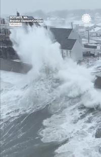
-
"Don’t do it" 2026 Blizzard obs, updates and pictures.
wxsniss replied to Ginx snewx's topic in New England
Yeah I was sure we'd hit 18. We were close... got a little robbed with subsidence in the closing hours while adjacent south shore was a 1-2"/hr assembly line. Obviously not complaining... there were much bigger losers in this storm. -
"Don’t do it" 2026 Blizzard obs, updates and pictures.
wxsniss replied to Ginx snewx's topic in New England
Every time. Funny how random strangers can share the same intense emotions, and conversely feel estranged from people immediately around them who don't get it. The chase, the exhilaration as the unlikely breaks our way, the thrill of the event, the sleep deprivation... then it's over and mundane reality returns. I jokingly warned my wife earlier tonight that I'm having post-storm dopamine withdrawal. Part of what keeps us coming back every year.

