All Activity
- Past hour
-
I noticed the HAFS-A in particular has been insistent since 06z in creating this moat before landfall when the hurricane is near peak strength in the 910s. doesn’t weaken the storm at all once the moat forms either.
-
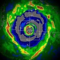
I finally got to radar and while the eyewall looks tremendous there is also a huge moat starting to appear.
-
I highly doubt this is still 145 mph.
-
Two insane IR loops with lightning data for posterity. New IR and the older AVN. No doubt about it, Melissa's eyewall is absolutely cranking at present.
-
T 8.0 https://x.com/ryanmaue/status/1982653620777824436?s=61
-
Thank you Jesus. Lets see what Melissa is made of.
-
Straight freak mode. Let’s go recon
-
Here's another Grand Targhee live webcam! You can ALWAYS count on the Jebman to keep you in the snow!
-
Perhaps.They're definitely en route again based on flight path now.
-
Wait, recon made another turn. They seem to be trying to find a flight path around the strong convection on the east side of the CDO.
-
For posterity
-
Given what ADT is cranking out, if Melissa maintains this appearance through the 5AM, it may still get the upgrade. Conservative estimates are still >140 kts.
-
Add this to the list of “what could have been” missions lol Obviously, safety comes first of course.
-
I hope they are okay, and of course, safety first. BUT GOOD GRIEF this sucks.
-
And here I was just talking about mechanical issues with recon and Eta's peak. History repeating itself. Damn...
-
Annnnnnd recon bailed.
-
Recon just made a 180. Hrmm...
-

Spooky Season (October Disco Thread)
WxWatcher007 replied to Prismshine Productions's topic in New England
39 at HFD, 33.4° here at WXW1. -
Man, I hate I won't be back home for the first (hopefully) snowfall of the year. I had to come to Guam for work, and fly back on the 31st/1st. Maybe I'll make it back for it?
- Today
-
Yeah, Jamaica is probably fucked.
-
Granted, Melissa's ADT is stronger than ETA's ever was. Eta got down to around 912 hPa on ADT, but recon found it to be 10 mb higher. Thus, it never achieved Cat 5 officially. Eta was also embedded inside of a WCARIB surface trough. Melissa's pressure regime is a little higher. So if it is indeed found by recon to be pushing the 910s or 900s hPa tonight, the gradient should support 140+ kt surface winds. But, yes, it would be surprising if ADT busted that hard again. Edit: I revisited Eta's estimates. It had a raw ADT of 8.0 and 7.0 blend at 912 hPa. But recon found 922 hPa when they finally arrived. The previous recon mission had mechanical problems, and the next mission may have missed peak. Also, we need to keep in mind that it is late October. The tropopause is a little lower even at a low latitude, and cloud tops can get a little colder on IR. So, dvorak satellite estimate algorithm can overdo the raw T numbers. Though I will always argue Eta should have been a Category 5 on reanalysis.
-
-
The only possible saving grace right now is that the satellite hasn’t matched observations, but idk how much longer that can hold.
-
There are 3 Atlantic basin hurricanes on record on this date or later that were cat 5 and they had these lowest pressures/highest sustained winds: -Mitch of 1998: Oct 26-28; 905 mb/180 mph; but landfall was way down at 80 mph on Honduras. The extreme rainfall though was what made it so deadly. -Hattie of 1961: Oct 31; 914 mb/165 mph; it weakened slightly at landfall in Belize to 915 mb/150 mph (cat 4) -Cuba hurricane of 1932: Nov 5-8; 915 mb/175 mph; but it weakened some before hitting land as it was 150/cat 4 on landfall The latest on record cat 5 landfall was on Cuba on Oct 19 (in 1924) near its peak intensity of 165 mph. So, IF this were to hit Jamaica as a cat 5, it would become the latest on record to make landfall anywhere by 9 days.


