

TellicoWx
-
Posts
2,632 -
Joined
-
Last visited
Content Type
Profiles
Blogs
Forums
American Weather
Media Demo
Store
Gallery
Everything posted by TellicoWx
-
Jan 30th-February 1st 2026 Arctic Blast/ULL Snow OBS Thread.
TellicoWx replied to John1122's topic in Tennessee Valley
Was just about to say, is it me or is the valley starting to fill in from north to south on radar. -
Jan 30th-February 1st 2026 Arctic Blast/ULL Snow OBS Thread.
TellicoWx replied to John1122's topic in Tennessee Valley
Flakes are really small, but enough for a dusting to have started on the truck and roof. -
Jan 30th-February 1st 2026 Arctic Blast/ULL Snow OBS Thread.
TellicoWx replied to John1122's topic in Tennessee Valley
Getting first flurries now -
Jan 30th-February 1st 2026 Arctic Blast/ULL Snow OBS Thread.
TellicoWx replied to John1122's topic in Tennessee Valley
I feel ya...snow dome here is holding strong. Still havent even had a flurry. -
Jan 30th-February 1st 2026 Arctic Blast/ULL Snow OBS Thread.
TellicoWx replied to John1122's topic in Tennessee Valley
Anything guys got so far no model picked and is part of reason I thought we had potential to bust high in places. Models picked up no omega right now, yet here we are. Now if 4am rolls round and its just a flurry here or there then may get nervous. -
Jan 30th-February 1st 2026 Arctic Blast/ULL Snow OBS Thread.
TellicoWx replied to John1122's topic in Tennessee Valley
Maybe it was a typo...suppose to be a 5 not .5 lol -
Jan 30th-February 1st 2026 Arctic Blast/ULL Snow OBS Thread.
TellicoWx replied to John1122's topic in Tennessee Valley
Tellico snow dome is holding strong lol...many systems have tried and many have failed in last 8-9 yrs. -
Low res NAM splatted my area
- 782 replies
-
- 2
-

-
- extreme cold
- snow
- (and 1 more)
-
Hello NAM nice to join us in Monroe co
-
The gusts to 35mph wording has me curious if at some point part of the WSW is upgraded to a Blizzard Warning due to whiteout conditions. Low chance I think.
- 782 replies
-
- 4
-
-
- extreme cold
- snow
- (and 1 more)
-
Gonna hit 50° here soon
- 782 replies
-
- 3
-

-

-
- extreme cold
- snow
- (and 1 more)
-
Looking at the forecast winds for the mountain/foothills zones, would not be shocked if a Blizzard Warning is issued at some point. The wind gust and light fluffy snow is right on the cusp of MRX's criteria.
- 782 replies
-
- 4
-
-
- extreme cold
- snow
- (and 1 more)
-
Worth a shot...once they figure out how to incorporate AI completely, they will privatize the NWS imo. Just the revenue alone all these half-wit social media pages are generating all is enough to get Big Brother Corporations watching.
- 782 replies
-
- 2
-
-
- extreme cold
- snow
- (and 1 more)
-
Sorry...had to lol

- 782 replies
-
- 6
-
-

-

-
- extreme cold
- snow
- (and 1 more)
-
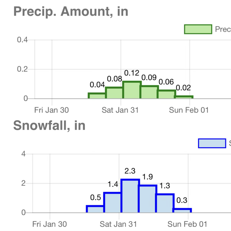
Not sure if they are in the middle of updating them or what, but Tellico and Sweetwater are 1-2, Madisonville is 2-5.
-
After reading that AFD...all I want to say is "No Sh** Sherlock". No direct mention of the NBM and finally talking about what the soundings have been showing all day.
- 782 replies
-
- 1
-
-
- extreme cold
- snow
- (and 1 more)
-
Hopefully by Sun morning it will have tonight's 0z model data
- 782 replies
-
- 2
-
-
- extreme cold
- snow
- (and 1 more)
-
Loudon and Monroe added to WSW
- 782 replies
-
- 1
-
-
- extreme cold
- snow
- (and 1 more)
-
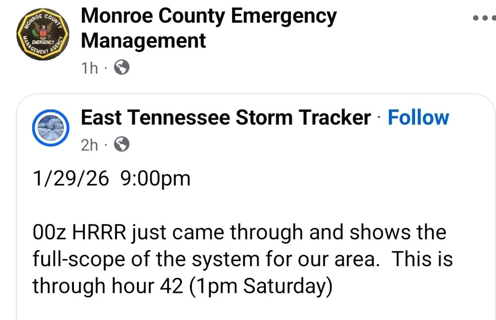
If one of you guys runs the East TN Storm Trackers Page then I apologize...but this right here is the scary/sad part. EMA directors re-posting a page of 42 Hr total of the HRRR is like posting a 240 HR GFS as verbatim.
- 782 replies
-
- 5
-
-
-
- extreme cold
- snow
- (and 1 more)
-
If they want to weight it like that, then have at it lol...but why use old data is beyond me. Always knew the thing was goofy acting, but seems to me they tried to automate being a Met instead of doing the hard work.
- 782 replies
-
- 3
-
-
- extreme cold
- snow
- (and 1 more)
-
Looking at various topo maps..fairly confident the RGEM is developing streamers out west off various bodies of water (ie Lake Barkley/Kentucky Lake)
- 782 replies
-
- 1
-
-
- extreme cold
- snow
- (and 1 more)
-
Icon tried to fill more of the valley in..just dont think its resolution is quite built for this setup tho.
- 782 replies
-
- 1
-
-
- extreme cold
- snow
- (and 1 more)
-
Those streaks in Ark also makes me wonder if there is bodies of water close to the origin of the streak. That is something else models may initially over look (basically lake effect snow except here locally).
- 782 replies
-
- 3
-
-
- extreme cold
- snow
- (and 1 more)
-
I actually stopped looking at what the algorithm has been putting out on the snowfall maps starting last night with the 0z runs. Probably sound like a worn out drum on here today, but something hasn't been adding up just going off sounding analysis (think it has something to do with the algo wanting to look at the normal DGZ vs looking at the super low one on the SHARPy). Think HiRes is correcting itself as time moves forward.
- 782 replies
-
- 1
-
-
- extreme cold
- snow
- (and 1 more)
-
While I would cash out now in a heart beat, there is enough support in the soundings (omega, low dgz but still thick enough for crystals to grow, and just enough pwat left) that there could possibly be another inch or two the models are not picking up (basically snow that wouldn't show on radar).
- 782 replies
-
- 7
-
-

-
- extreme cold
- snow
- (and 1 more)


