

TellicoWx
-
Posts
2,283 -
Joined
-
Last visited
Content Type
Profiles
Blogs
Forums
American Weather
Media Demo
Store
Gallery
Posts posted by TellicoWx
-
-
Final piece of the puzzle maybe @Holston_River_Rambler...MRX AFD this morning:
Once we get into the afternoon hours the lapse rates
above the low level inversion increase enough that a few hundred
J/kg of CAPE may be present in the atmosphere. This is enough to
warrant the mention of the possibility for occasional rumbles of
thunder, mainly across the central and southern Valley this
afternoon.
-
 1
1
-
-
9 minutes ago, Holston_River_Rambler said:
Even the ever stingy NBM is looking acceptable this morning:

Yeah, for that thing to even show greater than 2" is incredible at this range lol
-
3
-
-
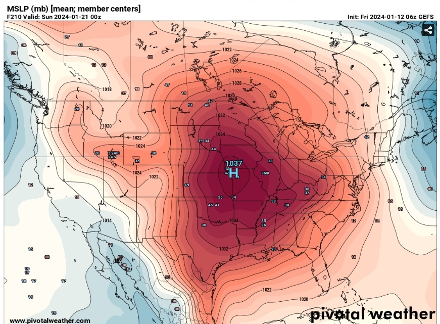
6z GEFs
-
3
-
-
GEFS then sets the Arctic Circle directly in the center of the US lol...did Goofy ingest the Day After Tomorrow movie.
-
3
-
 1
1
-
-
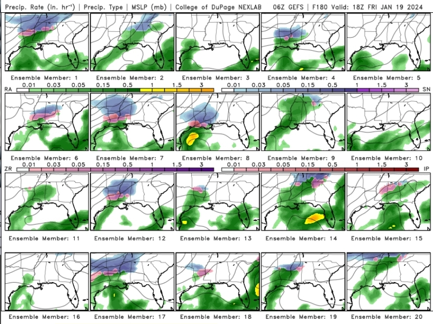
6z GEFS at 180....usually get at couple members supporting an OP at that range, not this many.
-
4
-
-
While the crazy uncles Op has wavered...I will say it's Ensemble has been steady the last few days.
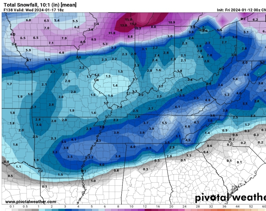
0z CMC Ensemble mean
-
2
-
-
Big jump on the 6z GEFS mean statewide..subzero mean temps starting to show up as well.
-
1
-
-
1 minute ago, weathertree4u2 said:
Luckily we know it will change with next run so
While I agree, and to a certain extent hope it does. That run is actually plausible. You have to go way, way back in the history books, but a system leading into and exiting this type pattern is there. Would be a 1 in 100 year type scenario.
-
2
-
-
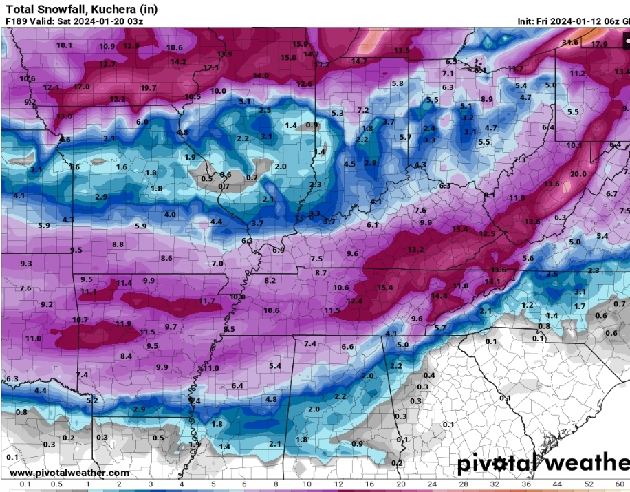
As crazy as it sounds...that GFS run had the potential to be way bigger than the above snow map...if the second system had got going a touch sooner and turned the corner it would have been lights out...literally.
-
3
-
-
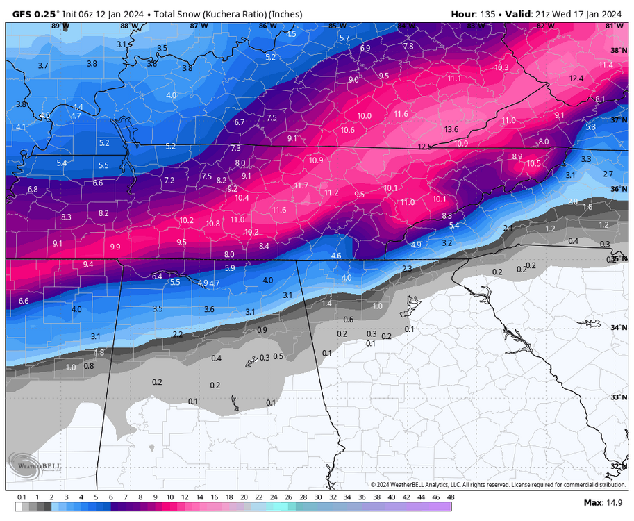
While I love snow...this would bring TN to its knees...2 storm total
-
6
-
-
4 minutes ago, Silas Lang said:
Let's all appreciate this possible solution. Think everyone would be happy with this!
GFS had so much fun it's said let's do it again right after that storm
-
4
-
-
6z GFS paste job

-
3
-
-
Quick search for streaks below freezing (have to go back to 1890's):
Nashville : 9 days
Knoxville: 10 days
So while tracking snow is fun, we could possibly looking at at least a top 5 historic cold streak.
-
1
-
 1
1
-
-
Now we have a legit threat...just need a little more diving action lol
-
1
-
-
2 minutes ago, Silas Lang said:
Thanks for this. I hope there is a way we can all score here. Anyone have any recent examples of similar storms? Just want to know what "success" would look like or if it is even possible or likely.
I was trying to think of a similar setup earlier today, and honestly I can't. Doesn't mean it didn't happen, so maybe @John1122, @Holston_River_Rambler, @Carvers Gap, or any of the other great historical posters we have here can. Kinda giving my age away a little, but first system I tracked (if you wanna call it that back then) using a hand drawn map while scribbling in the old noaa reporting stations info on a radio every hour, was the storm I won't name in 93.
-
5
-
-
The tailend of a front drapping across the gulf with a wave or energy left behind is historically the #1 way to get a southern snowstorm. Typically happens at the beginning of an arctic outbreak or when the pattern begins to relax (more of an ice threat then), every so often both. Miller As are typically not major deals for middle/west TN. What is not typical is there is usually alot more separation between a dying frontal wave and the cyclogenisis of a follow up wave (so model error may be unusually high with this setup). West/middle TN needs to score with wave #1 fluff bomb (due to very high ratio)...ETN has to rely on wave #2...this is almost like tracking two completely different setups at the same time.
-
7
-
-
Slight uptick in the GEFS...steady as she goes. Also, can see a little semblance of possible moisture being banked up against the Plateau/Mountains (that wouldn't be well picked up on until 24hr or less out, could enhance snowfall in those areas).
-
8
-
-
Not a true southern snow storm unless we get a half the board, cliff diving moment (only to get reeled back in)...like all the greats in the past had lol
-
5
-
3
-
-
1 minute ago, Carvers Gap said:
That is a good point. The UKMET went to St Louis. The Euro went to Savannah.
Yeah this system should bring back many happy memories and old scars of model days from long ago...finally we have a good Ole fashioned thread the needle for glory or bust system lol...Funny how so much tech has changed in past 10-15 yrs, but here in the weather modeling world things have stayed the same.
-
6
-
-
Big question is..."Is the Euro up to its old bias of holding too much back with 2nd = squash city?" *insert preferred cliff hangar music"...Stay tuned to tomorrow's adventure of "As the models flippity-flop to find out more.
-
5
-
-
Now need to get this inside the 72-84hr window...models are known to have an almost mini truncation point during that time. If any big move is going to happen that's the window I look at.
-
4
-
-
7 minutes ago, Carvers Gap said:
This is why I waited until this morning to look at modeling. I knew 0z was gonna be a mess. A dying wave which is followed by a second piece of energy is realistic as well, and I wouldn't be surprised to see modeling consolidate even more around that second piece of energy like the GFS had at 6z. When a strong cold front hits the GOM - dynamite. Good trends for all of the forum really.
Yeah this thing is almost acting like quasi phased system...with wave #1 feeding wave #2 from the Atlantic
-
2
-
-
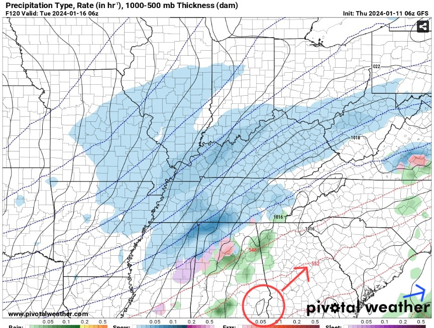
If it digs and slows/separates wave #2 (Red Circle surface reflection) a hair more...Blue arrow is wave #1 departing.
-
5
-
-
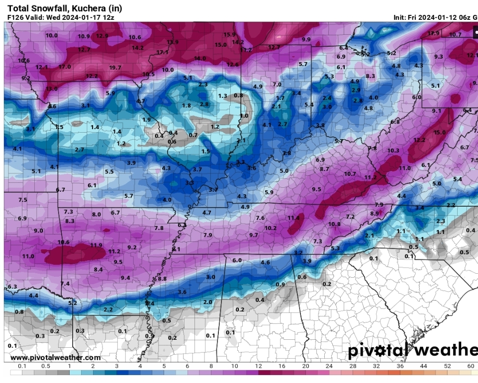
Middle and especially West TN looking more like they are gonna score a double whammy...1st from the initial wave before it generates a low too far east to help ETN, and the second that generates the Miller A type wave.
-
1
-

January 15th-17th 2024 Arctic Blast/Snow Event
in Tennessee Valley
Posted
Wait until they look at their Ole reliable 6z Dr No (aka NBM) lol