

TellicoWx
-
Posts
2,283 -
Joined
-
Last visited
Content Type
Profiles
Blogs
Forums
American Weather
Media Demo
Store
Gallery
Posts posted by TellicoWx
-
-
Gfs and CMC on 2 different planets with the evolution at 500. GFS opened 500 door wide open for a cutter...if it evolved that way, may get a quick front end (believe if anything would be quick change to some ice then rain). Would be rooting for the beginning of the week (CMC), than taking any chance with the end of the week.
-
 2
2
-
-
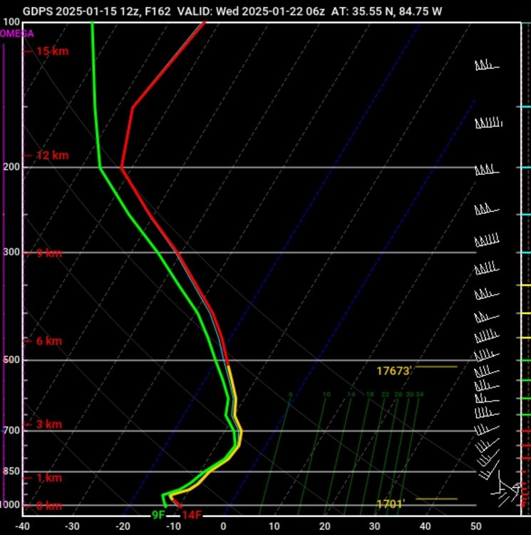
Not sure I have ever seen a DGZ this large...from 975 all the way to 500 (sounding from Chatt area on CMC). I would imagine that would have the potential to produce even more snow than modeled...not sure exactly.
-
3
-
 1
1
-
-
5 minutes ago, nrgjeff said:
Solid until - unlikely we receive much. Though at 25 deg. a tenth inch QPF is 2-3 inches of snow.
Not going to take much...if moisture can pull north this will be a very high ratio event.
-
5
-
-
12z Ukie maintains the storm..south of area.
-
 1
1
-
-
Main thing to me is the models are sending up big red flags for something coming in the SE. High impact events (snow/severe/flooding etc..), the honking usually starts blaring within this range...OPs give you the potential...Ensembles give you the impact area generally.
-
4
-
 2
2
-
-
0z GFS may be showing its bias at 500 vs the rest of the 0z models/12z Euro. Gfs is holding the trough up across the four corners...rest roll the trough east toward the gulf.
-
1
-
-
0z Ukie

-
1
-
-
Ukie has the storm/overriding...just a little farther south
-
2
-
-
Canadian...all gonna say is Kuchera lol
-
1
-
 1
1
-
-
18z GFS close to popping something good for Eastern areas 1/19-20
-
4
-
 1
1
-
-
18z GEFS mean with nice little bump...couple more members showing the Miller A/Apps Runner look
-
5
-
-
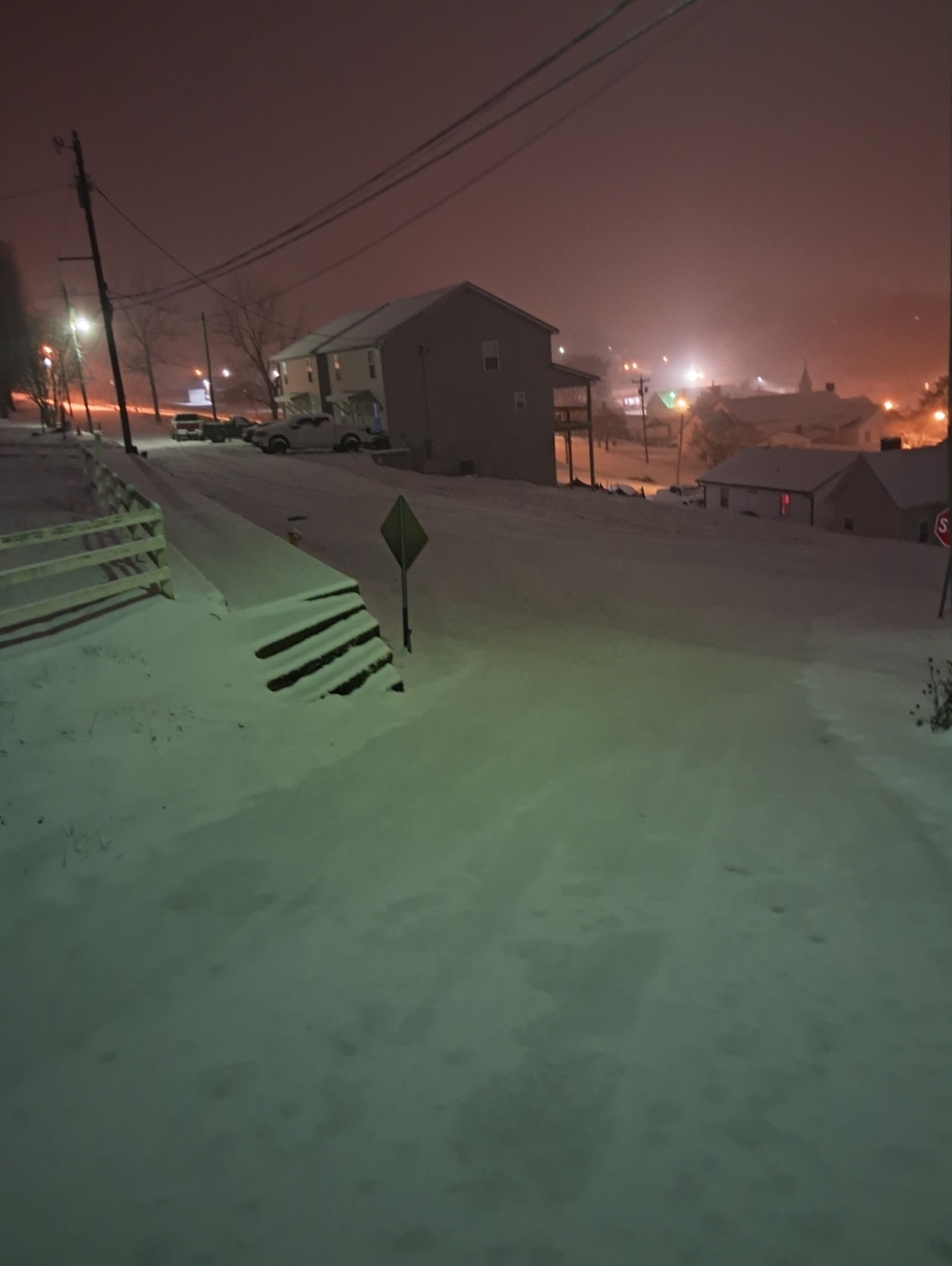
5.5" was my final total. Wonder if their data is going to be low due to measurements counting the ice compaction during the event.
MRX:

-
2
-
-
Haven't looked much at this time frame yet, but just at quick glance....keep an eye on the gulf. That is a classic signature showing on all the models. Fronts that stall in the gulf at that angle are notorious for spinning a LP formation. What's showing now could be the beginning of the models sniffing that out. If you want a true old fashioned amped up Miller A or Apps Runner..that's setup is how you get it across the southeast.
-
7
-
1
-
-
Still have light to moderate at times snow falling. There is definitely an 1-1.5" solid crust layer sandwiched between fluff. Going to be a block of ice once it begins melting off. Picked up 5.5" with cleaning snow board periodically...best I could keep track of with the sleet and freezing rain period. Picked up another .25-.5 in last hour with this low level moisture. I left it on the board, and will count it in morning (wanna see how much extra this wrings out). Considering I was only showing an 1" on models due to being in downslope hole, big win here.
-
7
-
-
-
Prob picked up another 1.5 in last 45 to hour.
-
8
-
-
19 minutes ago, dwagner88 said:
Big flakes are falling again. I'm shocked.
Glad you said something lol...went outside and it's pouring snow again. All the tire tracks in the road have filled back in, barely see them.
-
3
-
-
13 minutes ago, TellicoWx said:
This may help with how DGZ, saturation, and flake sizes work.
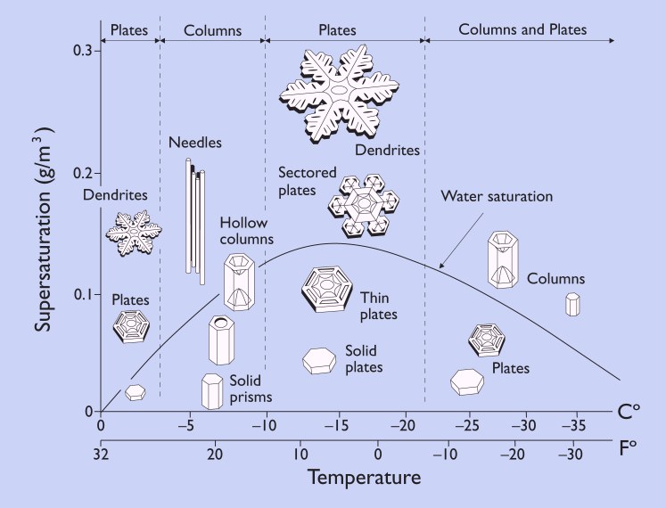
Forgot...for those who don't know what a DGZ is. It's where snowflakes are optimally made. The DGZ can move up and down in height...it's the section of the atmosphere....850, 700, 500..etc. where the air temp reaches -12 and exits -17 (chart just uses -10 to -20). Wherever that slice of the atmosphere is, then Rh/dewpoint determines the flake (100% RH is the curved water saturation line on the chart)
-
5
-
-
Just now, ShawnEastTN said:
Hope I switch back soon if that whole slug of moisture coming East is freezing rain I'm going to have quite the glaze. I've noticed holly bushes on the property are starting to drop more than during the height of the snow. The ice is starting to add enough weight to limbs to cause them to drop a bit.
That's what I was afraid of myself.
-
3
-
-
This may help with how DGZ, saturation, and flake sizes work.
-
2
-
3
-
-
6 minutes ago, PowellVolz said:
Is that the DGZ issues that @TellicoWxwas talking about?
Rates high enough for snow but hasn't filled DGZ enough. If it's only partially saturated then flake size will be smaller. Rates need a little more lift...should get that as the trough moves closer.
-
5
-
-
As those heavier returns over middle TN move overhead...more reports of snow now popping up.
-
5
-
-
1 minute ago, PowellVolz said:
Some of you with more intellect than me chime in please…. I don’t know if the Euro got this right but this system seems to have sheared out like it had been saying. Seems like the upper trough didn’t phase with the southern stream, or it was a very late phase. The ULJ is running over the top of the precipitation to our east while the trough is lagging behind in WTn. We still should be in the right exit of the trough as it moves through later on. So when the trough moves through, it can lift whatever moisture is left and wring it out in a NW flow situation. Thoughts?
That's pretty much what happened..think the exact interaction with the GL low kinda screwed enough with the whole setup to keep this from being an even bigger event as some of the GFS runs showed.
-
3
-
-
If rates can fill in...wouldn't be surprised if @John1122 and central/north plateau can squeeze out another 2-4...poss. 6 if everything lines up right. 1-3...poss. 4 central valley NE TN. But that's taking HRRR/RAP at face value for soundings/qpf
-
3
-

Winter 2024/2025 January Thread
in Tennessee Valley
Posted
Evolution of the weekend system has major impacts on anything showing the rest of the week. Until the weekend is nailed down, I'm taking everything past it with a grain of salt.