

TellicoWx
-
Posts
2,101 -
Joined
-
Last visited
Content Type
Profiles
Blogs
Forums
American Weather
Media Demo
Store
Gallery
Posts posted by TellicoWx
-
-
Congrats to everyone who scored. Glad a decided to take a nap this morning...all rain here.
-
 5
5
-
-
This is about one of the most complex systems I can remember IMBY. Just when I go to throw in the towel, the RAP does a 180. QPF is a major problem from my area, more so than a warm nose. HRRR could be right, but I've never seen the state line on the Skyway stay below freezing while Coker Creek/Rafter doesn't, and Tellico does.
-
 1
1
-
-
Well that didn't take long...all snow and elevated surfaces are white. Sister didn't believe me so made a mini snowball
-
4
-
-
Looking at Chatt PWS stations, looks like they will wetbulb below 32
-
1
-
-
Got a 50/50 sleet/snow mix now
-
3
-
-
If you would have asked me 3 hrs ago if I could get to 32 without wetbulbing, I would have said not a shot...yet here we are. T32...DP 26
-
6
-
-
1 minute ago, Carvers Gap said:
It is even more than that.
Yep...should have drawed the eyes bigger
-
2
-
 1
1
-
-
2 minutes ago, Carvers Gap said:
The 0z GFS is big.
I helped it out
-
3
-
 1
1
-
1
-
 1
1
-
-
4 minutes ago, John1122 said:
My brother in Hixson said it was raining at his house but one of his friends who lives reasonably close has a dusting.
I can drive a mile up the road I go from 37 to 31...there is definitely a tight gradient here
-
1
-
-
Temps starting to fall off the cliff here...28 in Madisonville. Good news is DP has stayed steady as air temp dropped.
-
4
-
-
2 minutes ago, Jed33 said:
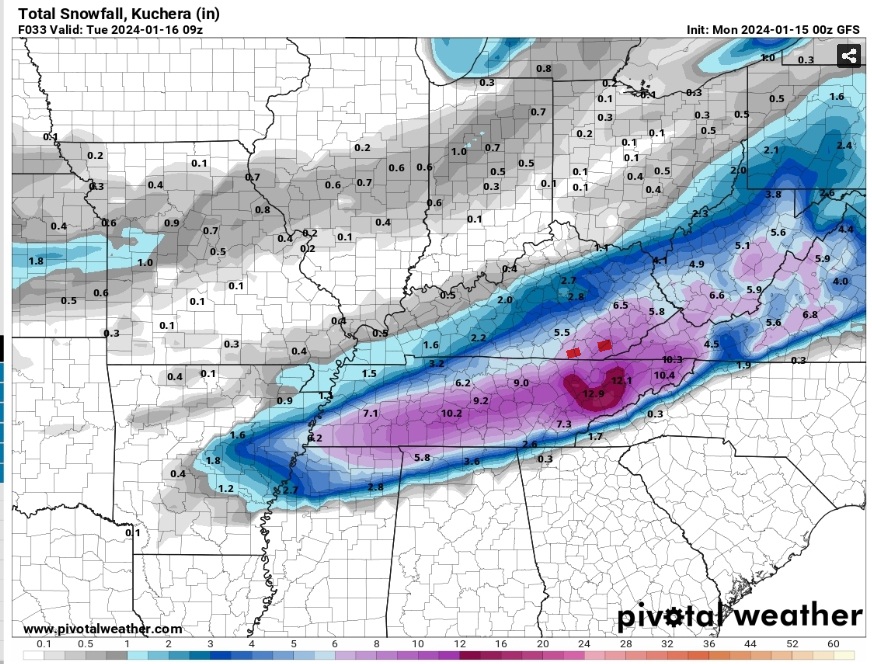
MRX evening update. Pay special attention to the last part! WPC has upped totals and thinks it will be easy to exceed 8in Central Valley and north! Astounding to say the least!

000
FXUS64 KMRX 150308 AAB
AFDMRX

Area Forecast Discussion...UPDATED
National Weather Service Morristown TN
1008 PM EST Sun Jan 14 2024

...New UPDATE...

.UPDATE...
Issued at 944 PM EST Sun Jan 14 2024

A bit late on the evening update here, but wanted to have a little bit to see some early time steps of the 00z guidance and see the radar trends this evening as snow began to make it into our CWA.

Main changes to the forecast were to update the PoP grids to
reflect current radar trends and pretty strong onset of snowfall
pushing into our area over the next 4-6 hours. Have seen several reports from Knoxville and points west that show snowfall accumulating on surfaces already. Albeit light, the fact that it`s already accumulating certainly lends confidence to the increase in
snowfall totals with the afternoon forecast package earlier today.
Current NBM hourly PoPs show this initial wave of precip moving out around 09z, with a distinct lull thereafter through about 13-14z before the main show moves in after daybreak. This seems very reasonable given the latest CAM guidance, but do not want to try and time a 3-4hr lull in precipitation given that it won`t have a significant impact on expected storm total amounts.

Another notable change was to include some sleet and freezing rain precip types down in the Marion county area. NAM forecast
soundings for Huntsville this evening did indeed show a weak warm
nose through much of the overnight hours. Conceptually this would
extend further ENE into our CWA in the warm SWLY flow around
850mb in that region. We`ve had a report of a light glazing in
parts of eastern Marion county which confirms this thinking. Not
expecting this to last as the column will continue to cool and
precip rates increase. But it is in line with the uncertainty in
ptypes, and storm total accumulations for the southern valley and
far southeast Tennessee.

Lastly, WPC has upped the snowfall amounts for the event in the I-40 corridor and points north. Didn`t want to make wholesale changes to the forecast for the evening update, but this trend doesn`t seem unreasonable given what`s already occurring this
evening. And it is worth noting that for the last few days, NBM
and HREF probabilistic guidance has been showing some healthy
probability of seeing storm total snowfall amounts easily
exceeding 8" across portions of the forecast area. Will let the
overnight shift make any substantive changes that are necessary since they will have the full suite of the latest NBM
probabilistic guidance as well as the 00z models at their
Did they hire actual meteorologists lol...their afd have been a tremendous improvement
-
4
-
1
-
-
Pulaski TN reporting 3"
-
7
-
1
-
-
2 minutes ago, jaxjagman said:
by the looks of my radar Memphis should at least have moderate snow right now
Last yard stick reading I saw posted was around 3"..been a few ago
-
1
-
-
Congrats to TYS on its "Iconic" 12" lol
-
2
-
-
9 minutes ago, Silas Lang said:
It's legitimately insane to me that tomorrow afternoon, nearly the whole state is still covered in snow on radar. It has been a long time since we have had a long duration event.

Not sure if anyone posted...2 hrs ago from SPC...show has really got rolling yet.
-
5
-
-
9 minutes ago, jaxjagman said:
It snowing pretty decent around Memphis it seems,Alabama line,anyone that way?
Lot of videos from Hun of sidewalks and cars encased in ice...Shoals area and north border on TN side is all snow with roads covered
-
4
-
-
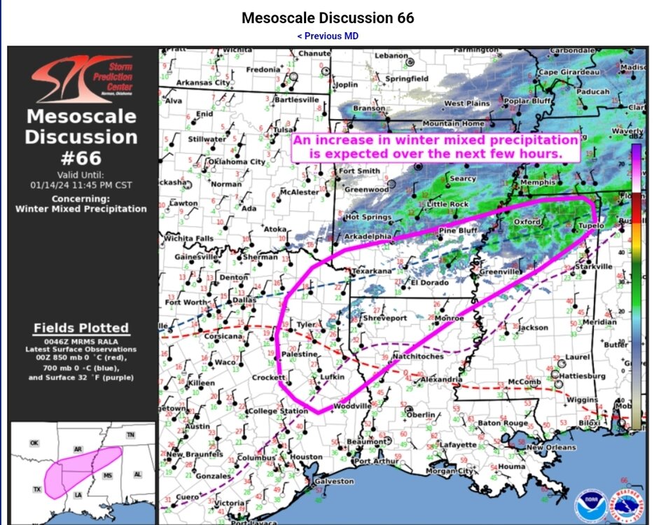
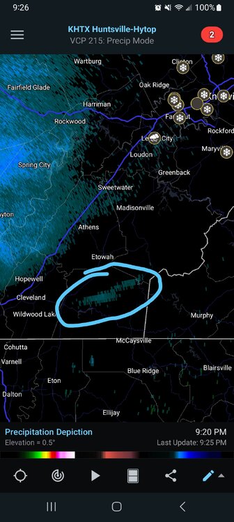
Think finally found the Arctic boundary on radar (blue circle)..if you loop the radar out of Hun you can see it moving due south
-
5
-
1
-
-
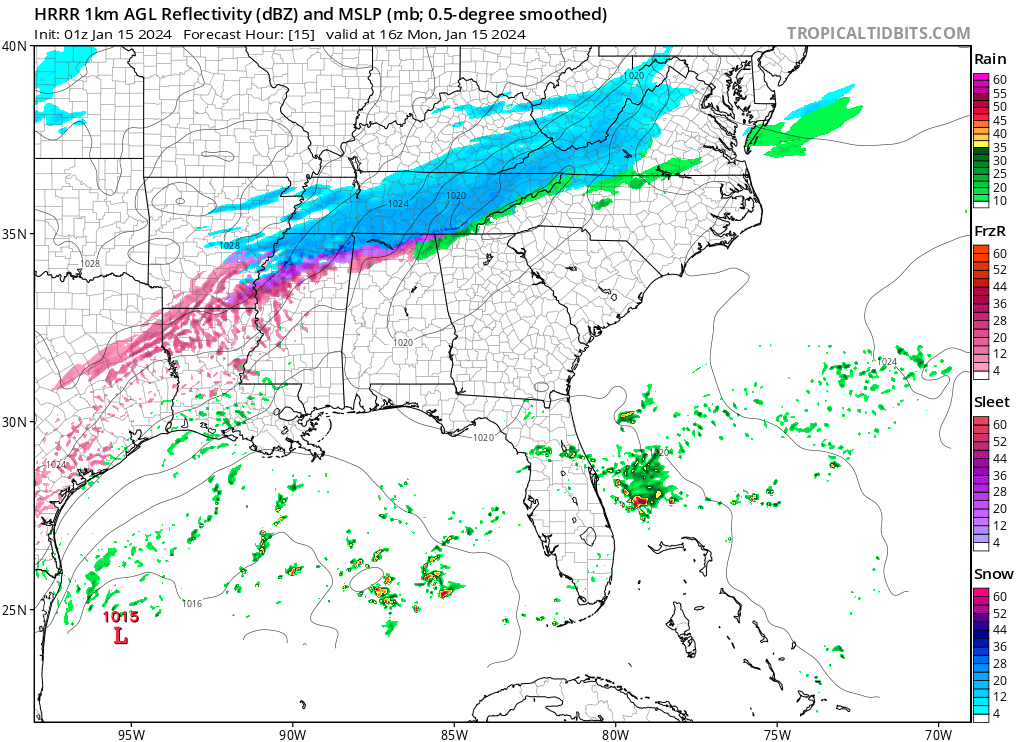
2 minutes ago, nrgjeff said:
Last visit and post for the night. @Chattownsnow and @Uncle Nasty I think the chart above from @TellicoWx eases the Chattanooga anxiety a little bit. We should be able to avoid a Dallas Cowboys style melt-down.
I'll feel better when I see snow falling. Warm air is hanging tough in KCHA but we're always the last to cool off. Already snowing in Knoxville. LOL Chatty. Back to the game!Hope you guys score...yeah anxiety little high here waiting on the temps..or I'm just old and impatient lol
-
8
-
-
-
4 minutes ago, Jed33 said:
0z NAM is easing off on the warm nose up the eastern valley and filling in. Looks better!
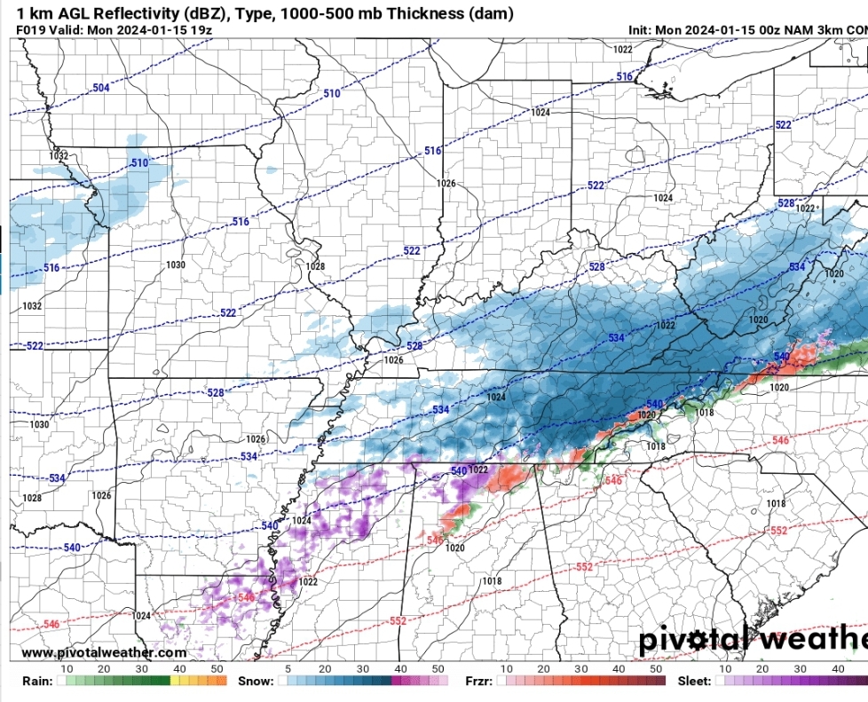
3k Sim radar is a thing of beauty for central valley guys
-
3
-
1
-
-
3 minutes ago, Jed33 said:
0z NAM is easing off on the warm nose up the eastern valley and filling in. Looks better!
Now it wants to join the party...nope not allowed lol
-
6
-
1
-
-
Temps starting to crash on north end of the county in last 15 mins..Madisonville at 33, Sweetwater 32
-
6
-
-
5 minutes ago, Chattownsnow said:

Wishing I still lived in soddy daisy right now. Every mile north is gonna count I think lol. East ridge TN here. DP and temps been steadily dropping slowly now. Fingers crossed here in Nooga
.I'm in same boat as you, and why I hate being in a "good" location on models. Temp and dew running way behind schedule now here...
T-39
DP-31
-
1
-
-
Flurries in Madisonville
-
7
-


January 15th-17th 2024 Arctic Blast/Snow Event
in Tennessee Valley
Posted
It's all good lol, will say in all my model watching years, this craziest storm ever. Was good learning lesson...fear the nose...even if arctic air is here.