

TellicoWx
-
Posts
2,101 -
Joined
-
Last visited
Content Type
Profiles
Blogs
Forums
American Weather
Media Demo
Store
Gallery
Posts posted by TellicoWx
-
-
9 minutes ago, Knoxtron said:
Man, reading this forum leading up to an event is peak happiness haha
I'm sorry if this is basic, but when it comes to snow ratios... does elevation matter in this scenario?
I'm at 2100', but I assume the snow formation (?) zone is well above me and ground temps control what precip type arrives versus any type of ratio
The DGZ isn't based on height (granted you would have to be at the Arctic for the DGZ to near the surface). It's based on certain temperature zone (-10C to -20C) relative to the RH in that zone. Saturate that area and flakes form. Temp from there to surface determines PType.
-
 2
2
-
-
15 minutes ago, Silas Lang said:
Maybe a dumb question, but is low level moisture impacted by ground moisture? I just say this because I remember some time ago reading about it, but forget the exact science behind it.
Not 100% sure..but ground moisture I wouldn't believe would for this. Now freezing fog that glazes everything would be I think. With this type airmass, larger bodies of water could play a very micro roll.
-
2
-
-
23 minutes ago, John1122 said:
The GFS starts out the same as the hi-res models but narrows the QPF field way more than they do as the run wears on. Not sure why that is.
Resolution issue...Globals have a hard time picking up low level moisture as time goes out...kinda like how the precip shield will typically fill in on the NW side on a LP as the event gets closer.
-
4
-
-
1 minute ago, PowellVolz said:
Anyone else feel like there’s an opportunity for someone in the valley to over perform?
.Not quite there yet, but chance (maybe). What's something else that has to get pushed out? The low level moisture that also banks up to the mountains. Sometimes it gets pinched and trapped, especially across NE TN and Central foothills. Lucky to pick that up on modeling 12-24 hrs out.
-
3
-
-
15 minutes ago, Carvers Gap said:
Tellico, you really seem like you might have a red tag in your past(met).
No, just too many years of watching these models and listening to you guys/ some others who are no longer on the boards.
-
4
-
-
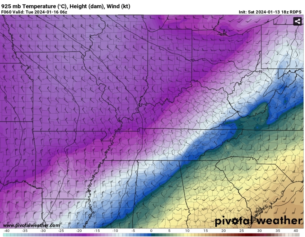
Here's the 925 map from the RGEM..you can see from the wind barbs are banking up against the Smokies, and how the 0 line is SW VA is trying to wrap (filling) it's way around the highest points.
Hope that helps for a visual.

-
5
-
-
Watch nearly any cold front on PWS stations..1st night west of 75 will be colder...as warm advects back in, east will be colder. (As always there are certain exceptions to that rule, but this doesn't seem to be one)
-
3
-
-
2 minutes ago, Carvers Gap said:
So it banks the warmer air against the Apps? That is pretty rare. Good catch.
I wouldn't even call it warmer lol..small Zone of 33-34 temps between the 925-850 layer..dps are really low, so could be end up as virga until it saturates (which the wet bulb is 99.5% below freezing). Valley is like a tub..cold faucet needs turned on for a minute to push the warm out or saturate it long enough to turn cold.
-
4
-
-
Looking at the RGEM soundings, the wind direction this doesn't appear to be a downsloping issue. More like what is seen on every front rolling off the plateau, it slowed the front just a smidge more. Doing so causes less time for the Arctic air to wash the warmer air out of the valley, as it gets pushed against the Smokies. It's like a quasi warm nose in a way...rates, speed, and several other factors can quickly erase this problem, but won't be ironed out until closer to the event.
-
6
-
-
MEG:
...WINTER STORM WARNING IN EFFECT FROM NOON SUNDAY TO 6 AM CST
TUESDAY...

* WHAT...Heavy snow expected. Total snow accumulations of 4 to 6
  inches.

* WHERE...Portions of East Arkansas, North Mississippi and West
  Tennessee.

* WHEN...From noon Sunday to 6 AM CST Tuesday.
-
1
-
-
MEG and JAN pull the trigger
-
2
-
-
NOAA runs two supercomputer system...nicknamed "Dogwood" and "Cactus"...ones in Virginia, one in Arizona. Currently they are numerically driven...but their replacements are being worked on that will change them to machine learning based. If the Enso states are being over done one way or the other, then a programmer changed their algos.
-
 1
1
-
-
1 minute ago, John1122 said:
The SREF is showing a NAMish solution which makes sense, as they share some DNA I believe.
Yeah it does...almost considered the nam Ensemble. Can also give a glimpse into the next nam run sometimes for trends.
-
1
-
-
For those curious, saw the 72hr NH verification scores last night in the MA forum...Euro is still consistently king (mid .9), CMC (low .9) is second, and GFS (upper .8). I use to have the link bookmarked, but can't find it...if anyone still has it.
-
2
-
-
See how it plays out, but a lot of model bias is showing up in each one. NAM has a long, long history of over amping. Globals tend to have a hard time even at short range with how far a true arctic front presses SE (too slow most times). Also, looking at RH data @700/850/925, some of the models output seem too dry on northern side. This arctic airmass "should" squeeze out every drop.
-
3
-
-
5 minutes ago, Holston_River_Rambler said:
It's the MSLP running into middle TN that makes me a little nervesome:
 A little more dig and we can get a clean Miller A, Mobile to Hatteras.
Yeah GEFs had everything from cutter to a slider
-
1
-
-
6z GEFS had a lot of scenarios lending support for the 12z...at 120 on 12z GEFs you can already see the return flow starting to stream north from western gulf.
-
1
-
-
2 minutes ago, John1122 said:
Looks like it was more than close!
So much focus is on #1, think everyone almost isn't noticing what's following on the heels.
-
3
-
-
8 minutes ago, Holston_River_Rambler said:
Close to a big dog again on the 12z GFS for the late week system
Talk about a potentially crazy scenario for NWS offices.."We have upgraded, I mean downgraded,....hell the warning is now a watch that may turn into a warning"...lol.
-
 1
1
-
-
Just now, Bigbald said:
Have been consumed with watching the first wave but seems like 12z suites are baby stepping the low more northwesterly up the east coast. Would love to see some bonus backend high ratio snow for east tn
If GFS is in the right ballpark, maybe a tad more than a backend fluff
-
1
-
-
With this system being a little flatter, it may leave the gulf more open for #2 (or the wave may turn into a #2 lol)
-
3
-
-
Flatter the system, the more the Hi-Res mods will carry more weight due to the complex features of the valley.
-
2
-
1
-
-
8 minutes ago, Silas Lang said:
GFS Southeast and less precipitation.
Definitely flatter....western side ticked north.
-
Think NWS offices are pulling the trigger quicker due to the Arctic air following the system. Giving an increased lead time to the public. Wouldn't be shocked to see MEG pull the trigger early depending on how rest of 12z wraps up. They have it built into their wording for up to 36 hr lead.
-
2
-
January 15th-17th 2024 Arctic Blast/Snow Event
in Tennessee Valley
Posted
Give me that kind of lift on the 18z RGEM and this type setup...and let the dice roll