

TellicoWx
-
Posts
2,283 -
Joined
-
Last visited
Content Type
Profiles
Blogs
Forums
American Weather
Media Demo
Store
Gallery
Posts posted by TellicoWx
-
-
GFS trying to follow with another system possibly a few days after the second one
-
 4
4
-
-
RGEM has been consistent...ICON also slowed down some...timing will play a big factor....still think it's more of a nuisance ice if anything at all.
-
2
-
-
0z ICON and RGEM coming in a touch colder at the onset of precip for 1st system
-
4
-
-
3 hours ago, Carvers Gap said:
Popped a lee side low as well. The last two runs have been tempted to take that energy around the corner. Hand off of energy for sure. But yes, jog south on that run. Good to see you posting, Tellico!
I've been lurking...you guys do a great job, and covered everything I could have added. Think we are headed for model mayhem...just gut feeling we may have some wild times ahead (May end up with 100" of fantasy snow but been awhile since we had modeling trying to sort thru this type upcoming pattern). For system #1, globals always has a hard time seeing the very low level cold (resolution not designed to) that gets trapped in the microclimates of the eastern valley...always has seemed like ice is a "surprise" event to most.
-
4
-
-
You guys along I40 and points north in eastern valley wouldn't let your guard down on system #1...last few runs keep taking small steps back south.
-
3
-
-
22° temp spread across the county..sitting at 70.1 currently
-
5
-
-
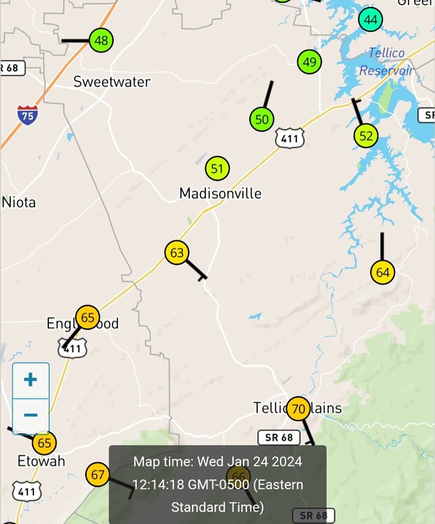
Tractor trailer flipped at Lenoir City exit on 75...Hwy 411 is beginning to ice between McMinn Co and Madisonville
-
1
-
-
-
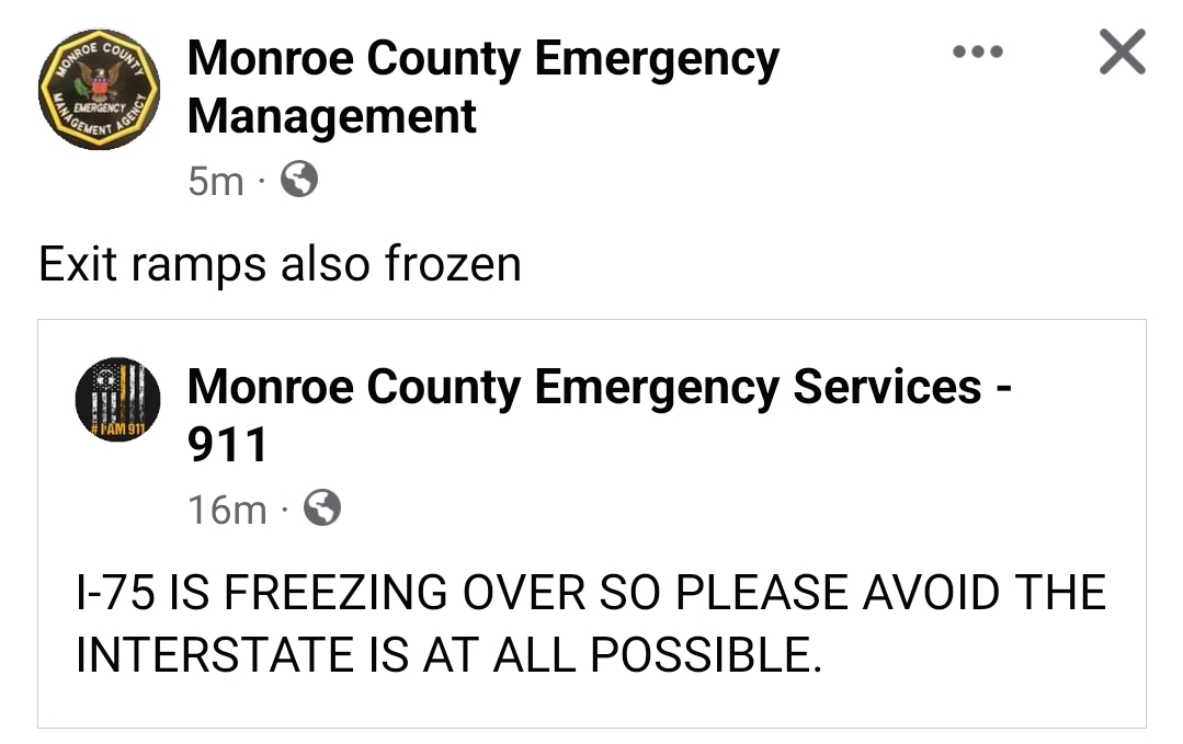
Sheriff deputy is at the I75 exit in Sweetwater, said it has turned into a solid sheet of ice on the whole thing...can't respond.
-
I75 beginning to ice over here...wreck at mm 61
-
2
-
-
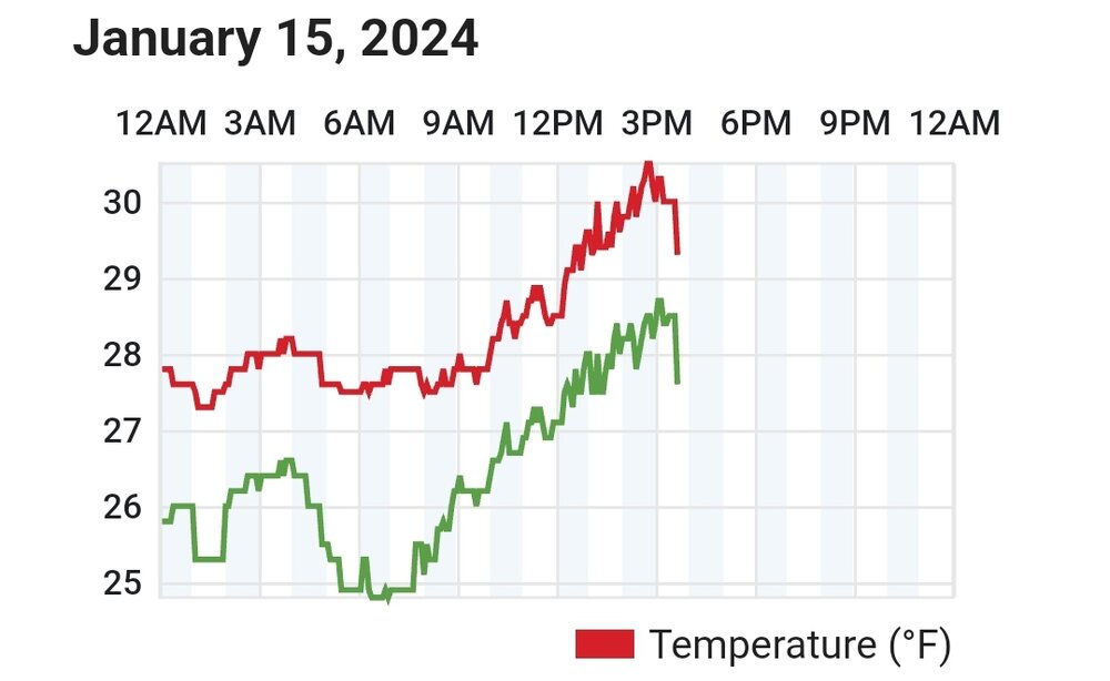
Officially below freezing..31.8 with light rain...no model had freezing rain anywhere near southern Monroe.
-
1
-
-
23z HRRR for my area.
Sounding..40
Reality...32.4 DP 29
Skyway temp has started falling, went from 43 to 39 in last hour at 2000'...way colder than modeled as well.
-
4
-
-
Here where I'm at, we always get WAA...still waiting. Made it up to 43.9..currently 34.3 with no wind. DP has went from 30 to 28 in last hour.
-
2
-
-
CAMs still adding about 2-4" around Knox with the Lee
-
4
-
-
Not liking the 3k NAM FZR totals for my area...it's closest so far on ground truth temps.
-
1
-
-
And this is in response to the Lee if it forms up
MRX AFD:
The same guidance
suggests a surge of colder air aloft will arrive tonight,
potentially leading to light snow tonight
-
1
-
-
-
6 minutes ago, Vol4Life said:
When is the Lee side low supposed to form?
According to CAMs it's beginning to form now...should see it fully formed around 03z
-
1
-
-
One of the tricks it may be up to, is Lee are notorious for being under modeled 6+ hours out on precip. If it hangs around as CAMs suggest tonight, could be interesting for everyone.
-
5
-
-
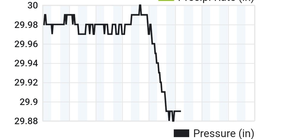
As the pressure has started to rise, the 850s can start pulling back south. Add in the rates able to tap that, time of day it's occurring, downslope winds starting to ease up and switch..and you have a great recipe. Look at the time stamps of the valley PWS coinciding with everyone posting how goose feathers have picked up.
-
3
-
-
While this has been a very complex and surprising system..don't think it's done with all of its tricks.
-
3
-
-
Just now, Carvers Gap said:
TRI has been above freezing all day. I think warming yesterday (clouds moved in later and at perfectly the wrong time) seeded the problems for today. We got too warm yesterday afternoon due to sun. Then clouds moved in and capped that warmth so it couldn't radiate out. Time of day IMO was the single, biggest determining factor of who got what.
That definitely didn't help matters..more heating makes it harder to scour out, especially if you lose radiational cooling. Bath tub theory..clouds act as a partial clog to drain out the heat.
-
10 minutes ago, Carvers Gap said:
For several days, the NAM busted badly in the eastern valley as it didn't have any snow east of the Plateau. Globals did much better over here. The final run of the GFS before the event is probably going to verify for the most part with the exception of the foothills which mostmodels basically failed w/ until the last minute.. The Canadian sniffed out the problems in the eastern foothills first. Once the NAM came on board yesterday, it also had it. The HRRR also had it to some extent when it came into range. It is also worth pointing out that the NAM doing well in middle and west TN while not doing well here is easily explainable. It was closer in time to the event and those areas got cold quickly(better ratios). On this end, we were still several hours behind from a modeling standpoint...and it overdid accums on the Plateau and Cumberlands which was feedback. I do think the NC lee side low caused it problems. Once it lost that feedback(and we got closer in time), it did much better. It didn't dial-in here until about 12-16 hours to go. The other problem is that as the system backed and slowed, the NAM tended to feedback. The ICON is probably gonna be the big winner in all of this statewide, and that is probably a shock to most - me for sure. The 3k NAM was particularly good. The 12k NAM was terrible. The RAP and HRRR have been really good as well. I don't like the RAP, but it has done decently this go around.
As MRX noted, no model had the warm air pushing to I-81 in NE TN.....personally, I think the front stalled at dawn at the Plateau and then daytime temps caused issues. The front stalling on the Plateau is not unusual. As Tellico noted the other day, Knoxville has a nice pathway for cold air from the Plateau. Chattanooga and TRI do not. The big red flag was when temps in NE TN yesterday beat forecast highs by 8 degrees. That produced a lot of warm air to scour as we got cloudy at dark, and warm air couldn't scour. Then it go banked against the Apps this AM.
The NAM itself is I think a false positive. It got some things right, but for the wrong reason IMO. It got incorrectly amped and missed the track, but its snow totals worked out. Why? The cold air moved aggressively into middle and west TN and allowed rates to be crazy good. I have roughy 4" of snow right now. My ratio might be 8:1. If it was colder, I would likely have double that. So, whichever model moved the cold in most aggressively is correct...and I don't which one that is....probably the RGEM? The other thing is that the over-amping of the NAM gave it some semblance of expanding the precip shield. Its precip shield was juiced due to feedback and had a bad track in the East - plenty of snow fell east of the Apps which it didn't have. In reality, that precip shield was going to fill in as the rush of cold air squeezed every drop of moisture out of the air - it was impressive. The entry point of heavy precip was decently modeled and didn't change much.
Still looking through some of the reports from middle and west TN which are incredibly helpful. I think the main bust(and let's be honest, nobody cares if a model busts and they get more snow than shown), is the foothills...and that may take some time to figure out.
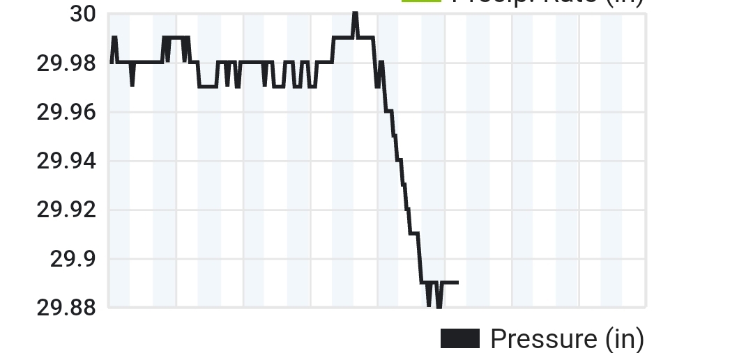
Great analysis...I think in the end the wave that generates the Lee Low wasn't well handled. Once in range the models start being able to hone in so to speak. Combine it with the plateau slowing things down naturally...it stalled and pushed back the Arctic air, especially at the downslope prone areas. With the pressure stabilizing now, more areas are going to be on the correct side of the Lee. Allows the artic to resume its push.
-
2
-
-
Pressure has bottomed and leveled..wave has passed by and temps are responding (Sweetwater PWS). If you have stayed all snow...buckle up buttercups..you are about to be rocked lol
-
5
-


Winter 2024/2025 January Thread
in Tennessee Valley
Posted
12z NAM bringing ice north of 40 in middle TN