

TellicoWx
-
Posts
2,101 -
Joined
-
Last visited
Content Type
Profiles
Blogs
Forums
American Weather
Media Demo
Store
Gallery
Posts posted by TellicoWx
-
-
Nice hit west of the plateau on the 18z GFS..think you guys in that area are in a good spot.
-
 2
2
-
-
Unless something drastic changes near the Hudson Bay...anything that forms is going to cut that way (attacking the weakness between the two Highs). With each "upgrade", it's almost like their is truncation periods around every 72 hr time-frame where larger moves happen.
-
2
-
-
28 minutes ago, Daniel Boone said:
Really need that TPV to assert under the block to help stave off that thing from cutting. That's the piece of the Puzzle that's missing and hurting the portrait from being a masterpiece.
Strong LP under that block, whether 50-50 , 60-40, or even 70-30 for that matter should get it done.
The Blizzard in the Dakota's is an example of a Storm cutting and going toward the block before stalling. A strong enough system will cut without a strong enough mechanism to weaken or shunt it.
I remember tracking one several years ago that had a similar solution at this range (except the roles were reversed between GFS/Euro). Everyone (myself included) thought the GFS was out to lunch...storm ended up cutting straight into the block. So agree with you completely.
-
3
-
-
1 hour ago, Carvers Gap said:
The 18z GEFS looks awfully similar to the 12z GFS...awfully similar.
Another step forward on the means..nice and steady. Have a feeling we are going to see a correction good/bad in the next 24 hrs.
-
2
-
-
Treat the Ops as 1 more ensemble member..GEFS and CMC ensemble took steeps in the right direction as far as the mean...all solutions still on the table when you look at their 10/90 depth spreads.
-
2
-
 1
1
-
-
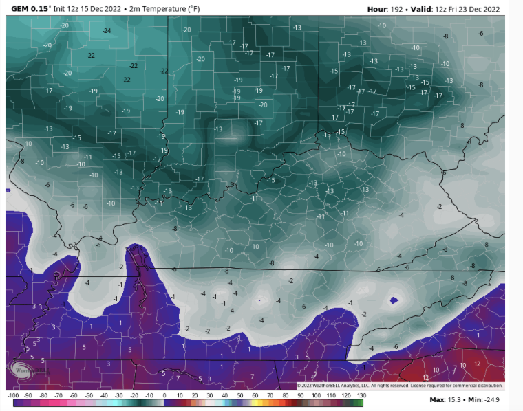
Safe to say that if, big "if", that 12z GFS run came to fruition...much of the eastern half of the US is closed during busiest travel time of the year.

-
1
-
-
1 hour ago, Carvers Gap said:
Just getting able to dig through the 12z suite. The Canadian....
GFS said hold my beer lol
-
1
-
 1
1
-
-
Switched to heavy snow here about 10 mins ago...ground already turned white, roads are still just wet
-
2
-
-
Heavy sleet here
-
3
-
-
Oakland, TN...6" measured

-
9
-
1
-
-
Tornado watch hoisted for the Florida panhandle...possibility of strong tornadoes.
-
2
-
-
Huntsville changed over to sleet...cold white puddles forming in Florence, AL
-
2
-
4
-
-
That's like a carpenter who doesn't being a hammer to work, instead he brings a spoon lol...someone needs to ask him what he uses then..tea leaves, 1-900 psychic hotline from the 80's...im curious now
-
3
-
-
We will see how they score in the end, but GFS (been closest out west) doesn't back down on the final run before the event.
-
4
-
-
1 minute ago, Runman292 said:
Lol at "rarely looks at deterministic models".
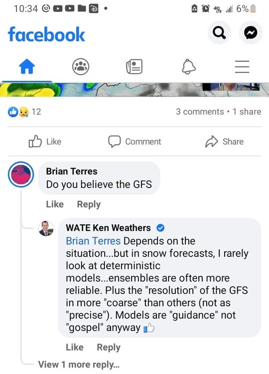
And it shows lol
-
1
-
1
-
2
-
-
Heavy snow and winds gusting to nearly 40 mph over NW AL...system starting to get cranking
-
9
-
 3
3
-
-
1 minute ago, John1122 said:
Friend in Memphis posted a video of her dog playing in 3-4 inches of snow with big flakes still falling and lots of wind blowing it around.
Not bad for 1" lol
-
3
-
-
Just now, McMinnWx said:
Is there a particular model that has handled this storm the best?
Goofy probably been the closest
-
1
-
1
-
-
Thundersnow reported just north of Grenada, MS...1"-2"/hr rates
-
3
-
-
-
5 minutes ago, John1122 said:
Some blizzard warnings being issued in parts of West Virginia.
Beginning to wonder if those don't get extended south if the higher amounts materialize. Think people are overlooking the winds
-
2
-
-
Update from chaser earlier near Collierville area...he had to pull over. Near whiteout/blizzard like conditions.
-
6
-
1
-
-
With a highly convective environment over the valley, not surprised to see the CAMS correct to what they are best at for close range.
-
1
-
-
1 minute ago, Silas Lang said:
Is there some kind of valley enhancement going on? I kind of jokingly asked about it earlier, but this run it seems super prominent. Notice how the snow is not elevation dependent here.
EDIT: you can really see it on the 3k NAM.
Basically merging of the dynamics right over the valley as the energy near the gulf lifts up to our south
-
1
-
2
-


Historic Christmas Cold & maybe snow?! Dec 23rd-30th
in Tennessee Valley
Posted