

tim123
-
Posts
6,682 -
Joined
-
Last visited
Content Type
Profiles
Blogs
Forums
American Weather
Media Demo
Store
Gallery
Posts posted by tim123
-
-
4 minutes ago, rochesterdave said:
WRF hinting at some crazy localized stuff. It sniffs these out sometimes. Tomorrow night mostly. VERY localized

Drops over a foot in niagara County. Niagara peninsula.
-
4 minutes ago, vortmax said:
Puff bombs
This is 25 30 to 1 type stuff. Would you agree?
-
16 minutes ago, rochesterdave said:
Snowing moderately in Irondequoit. Light winds.
Think you may be a big winner in county. Snowing nicely in walworth inch down since 6pm
-
 3
3
-
-
Looks like a nice band starting to drop south off lake.
-
1
-
-
18 minutes ago, Leelee said:
It's within 5 days now and the shortwave is south of mainland Alaska. Time has run out with how models are today.
Absolutely not
-
23 minutes ago, rochesterdave said:
Surely looks to be WSW.
Thats because a secondary trough is going thru
-
2
-
-
4 minutes ago, rochesterdave said:
P&C slashed overnight totals for Rochester. Looks more like a westerly wind event now as opposed to a northerly flow I was hoping on.
The usual suspects get hit.They change these every 20 min. Always was a wnw to nw flow. They always do this.
-
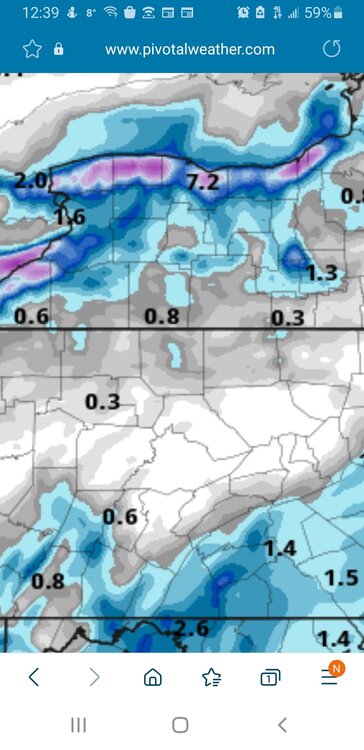
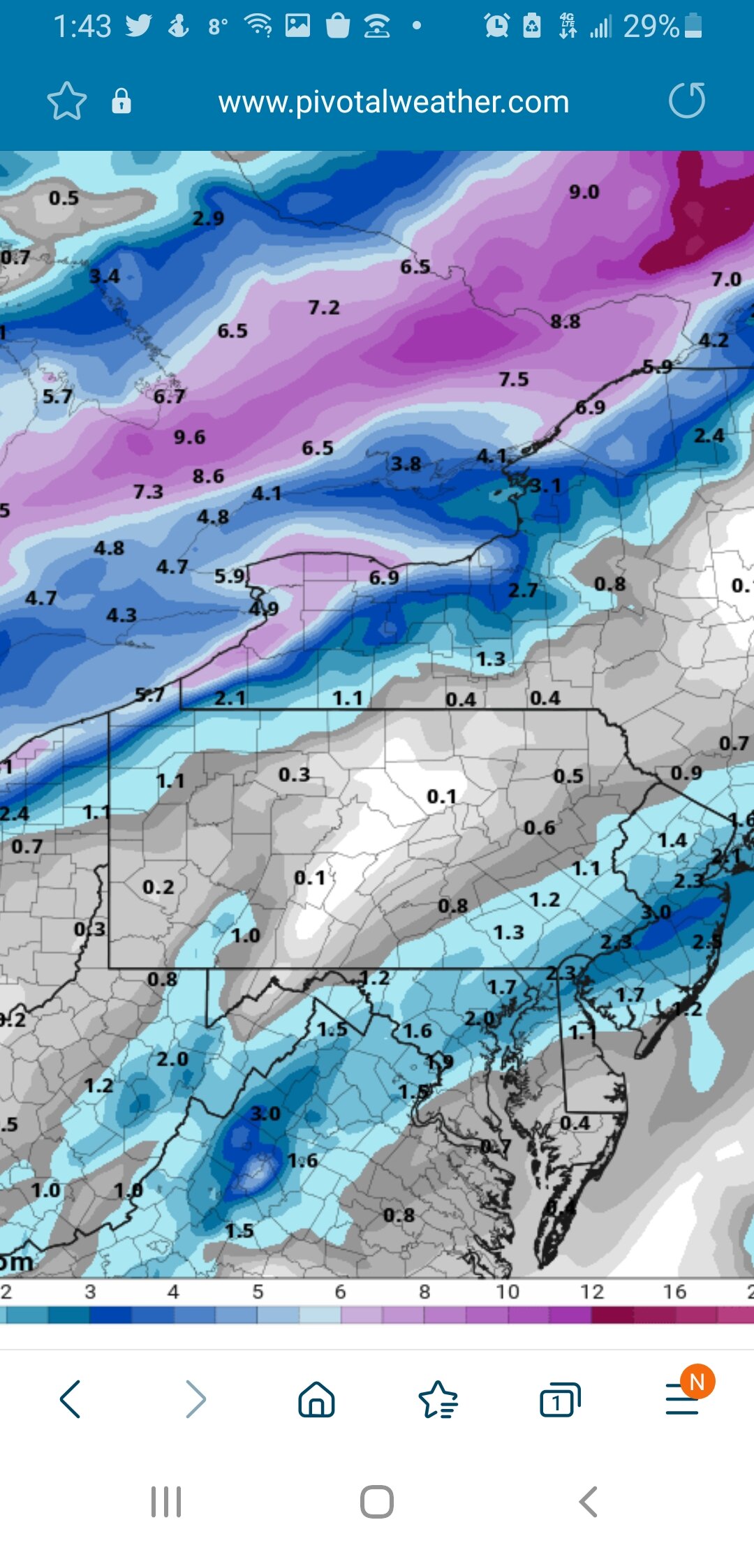
Pretty stout precip for lake effect on euro. That would be 4 to 6 inches tonight into tomorrow.
-
1
-
-
4 minutes ago, vortmax said:
They still ain't buying it... HWO BUF:
On Thursday a storm system is forecast to track across or just to our west of the region. This may bring a warm weather resulting in snow melt and a half inch to inch of rainfall. There is a potentialf for flooding from high flows, ice jams, or a combination of both. Strong gusty winds are also possible. This far off there remains considerable uncertainty in the track of this system.
They love forecasting storms moving west. If this was going to be a snowstorm they wouldn't even have a hwo out yet
-
Almost looks like a secondary cold front coming thru western ny now
-
-
Huron and gb are gushing. Very strong response. Probally due to recent warmth on surface of lakes.
-
1 minute ago, rochesterdave said:
IDK about advisories but it’s a sneaky event. Well aligned winds for south shore. Light winds which is always good. Tonight and tomorrow night look good. I’ll be watching for meso lows.
Precip is exploding on the west end of the lake.Yeah looks like a strong lake response already
-
1 minute ago, tim123 said:
So does wrfs
-
1
-
-
3 minutes ago, rochesterdave said:
Canadian still likes Ontario these next 48 hours
So does wrfs
-
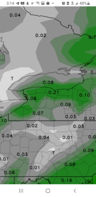
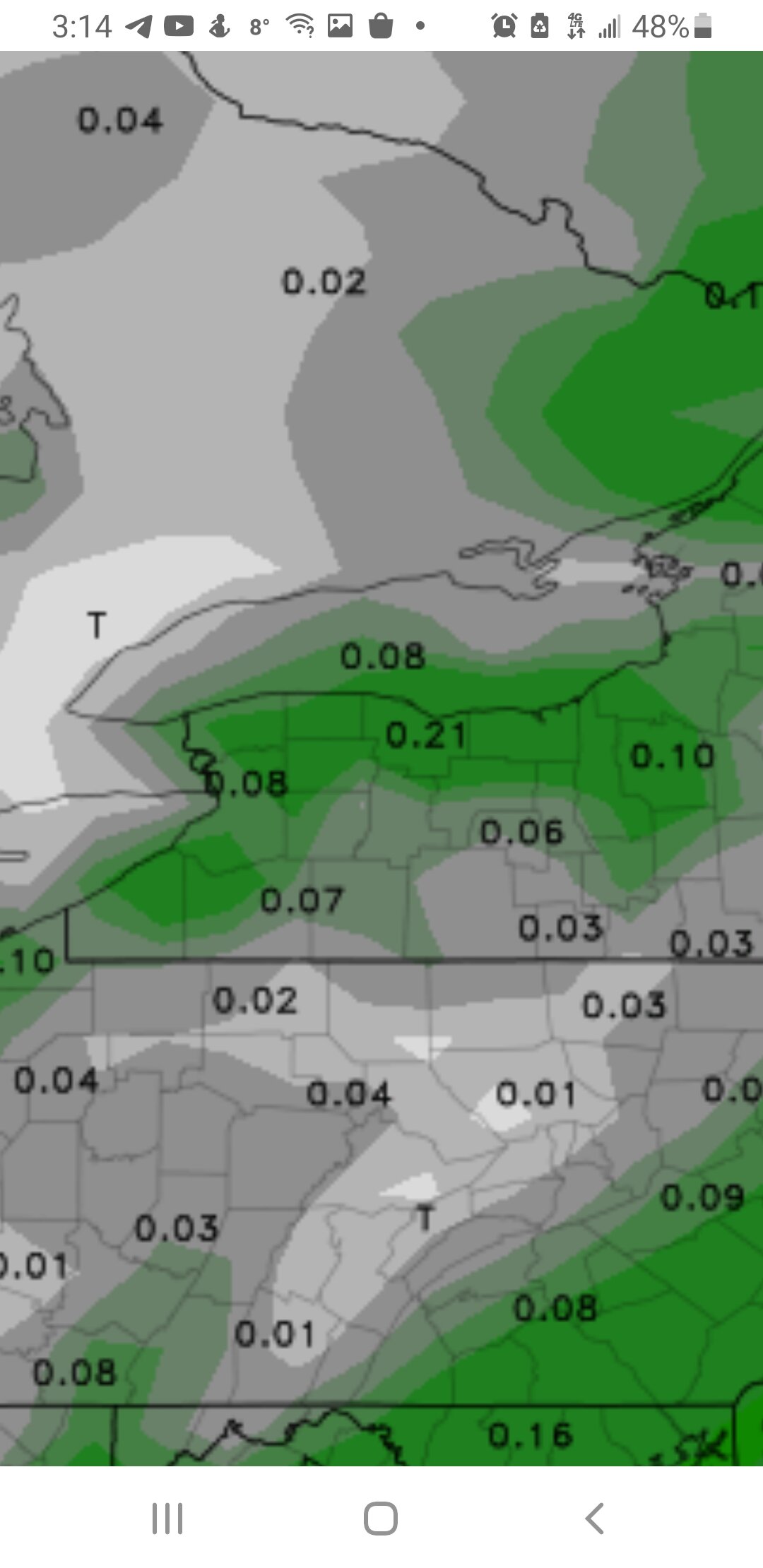
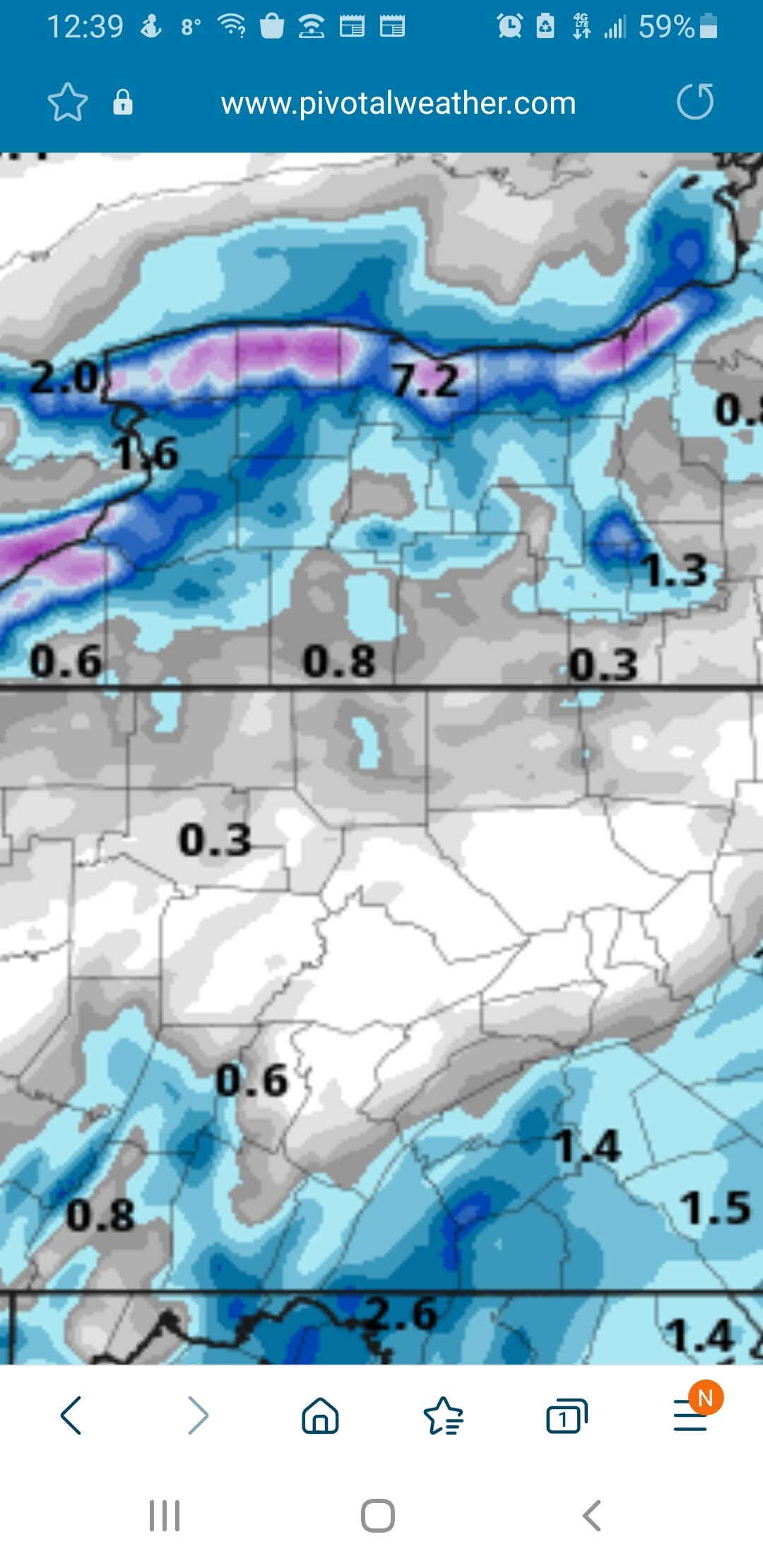
Advisories should be up for entire south shore. Could see this event drop 4 to locally 8 inches.
-
Icon shows a ice storm
-
Lake snow looks kinda robust on meso models. Niagara to Oswego 4 to 10 inches.
-
1
-
-
54 minutes ago, Leelee said:
The lows on cold nights were like 5-8 degrees colder in ROC than BUF. ROC had 5 nights below 0, BUF never went below 0. Not sure why that is, I would think the opposite with predominantly northern flow and more snowpack.
Calm nights radiational cooling draing cold from upper Genesee Valley into lower Genesee Valley.
-
This cold has been impressive past month. Getting old with the single digits obove and below. Give me normal with lows in teens with more snow.
-
1
-
-
Even with the upgrades and gfs is better than it used to be. It still has a tendency to catch big storms in long range to loose them in midrange.
-
Just now, TugHillMatt said:
Agreed. Euro then follows that up with a Valentine's Day snowstorm that would be the most widespread snowstorm of the season for several subforums. If only:

Gfs came close again today to phasing
-
1
-
-
Just now, TugHillMatt said:
I vote we start a new thread where Syrmax and tim just roast one another. Such random little insults.
Let's do it.
-
7 minutes ago, Syrmax said:
Adults are having a discussion. Go back to your room and take your meds.
Go get your shine box piddle pants. Now go get back on your moms teet and ask for more bitty. Guy ladouche
-
 2
2
-

Upstate/Eastern New York-Pattern Change Vs Tughill Curse?
in Upstate New York/Pennsylvania
Posted
Not much overnight. But its dumping out out now.