

radarman
-
Posts
14,571 -
Joined
-
Last visited
Content Type
Profiles
Blogs
Forums
American Weather
Media Demo
Store
Gallery
Everything posted by radarman
-
Berkshire East just announced opening on Thurs 12/17
-
Berkshire East has been hammering away and I saw cat tracks on the webcam tonignt. Wonder if Pro Lurker has heard anything about opening?
-
FWIW, Killington reported 3" today. Mt Snow snowed lightly most of the day but the cam on the stake really only shows like a half inch, maybe a little more. Sugarbush reported 2". Radar did look decent over Killington.
-
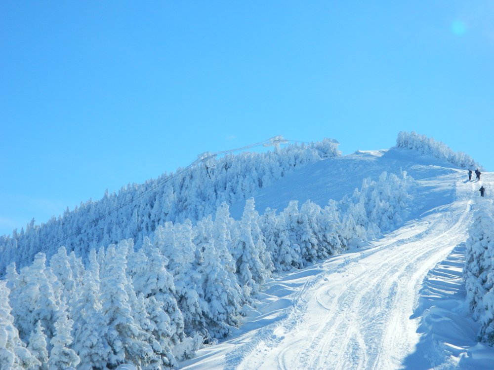
Cool. Scotch Mist is now called Black Diamond. Makes you wonder why they changed it. Kind of like they changed my town name from the perfectly nice Cold Spring to, well... nvm. I presume the twisty diamond you mention is Lower FIS, and that's also just a wonderful long pleasant mogul run. The short hike out at the bottom tends to keep the crowds away so you can save it for later and still find fresh tracks late morning.
-
You can't really go wrong over there either. Rumble woods accessed from the top of Middle Earth is absolute prototype steep eastern trees and small cliffs, and even the trail itself premier Vermont cut narrow moguls down the fall line. Ellen summit is a little more exposed with scrubbier trees as you pointed out. So if it's foggy or especially windy you're better off elsewhere. Also, sometimes after a big storm, they might hold off on opening Ellen an extra day. But if you hit it right, especially on a bluebird, I don't think you'll wish you had splurged on the LP ticket.
-
yeah and tack on a 3 hr drive on either end. But once home and showered, you feel amazing.
-
The woods skiers left of Black diamond holds literally like 1-2 lines, but it's frickin chest deep in there... And the other side ain't bad either Nothing whatsoever against LP, but I have a special fondness for the Ellen summit. I think it's overlooked sometimes.
-
As for on the actual trail, 12/1/18 was the best I've ever seen it. 90" in November and very little wind... a pure west coast style powder puff. Skinner's reward.
-
Sparse trees on either side of Upper FIS are usually good to great. Not many turns in there, but they hold it. Cut over through the woods from the top of black diamond and it opens up.
-
I mean, I think this says it all about reporting nuances. Close to zero percent chance Mt Snow gets less than Ascutney. I'm always fine with throwing caution flags when it comes to personal anecdotes, but I feel pretty good about anecdotally coming to that conclusion.
-
Well, even here we get a pretty substantial percentage of our snow nickel and diming from northern stream shortwaves and on the front side of cutters/SWFEs... ie. not pure coastals. I'd be inclined to suppose that Killington incrementally scores with the CAD events based on latitude, but we know also that the west side of the mountains are prone to torching and they're tickling that edge pretty good, whereas Mt Snow has some buffer. At any rate, I don't entirely mean big nor'easter type events, which as you say likely don't contribute hugely on a percentage basis, but also your standard fare March clipper that blows up under LI, quick hitter anafrontal waves, waves on cold fronts hung up offshore, etc. Basically everything synoptic with the Atlantic as the primary moisture source.
-
Nice post as usual. If some objective truth were available I'd be shocked if KMart gets 100 more inches than Mt Snow. I mean when folks talk about Killington posting 8" with bare grass showing, that's a non-negligible amount of inflation. Or maybe as you said the southern areas just don't care as much or aren't clearing their boards every hour. Over the course of a few seasons I'd be interested to identify all these events where Killington is cleaning up and Mt Snow isn't, to the tune of 90 something inches annually, which is the difference basically between MBY and YBY.
-
Again, we have plenty of experts on this here, and you may well be one of them... so take with a grain of salt... but I've always felt that where Jay cleans up is on the lingering N/NE flow from bombing coastals in N Brunswick, etc., throwing back moisture across SE QC and the extended St Lawrence valley and they being the first beneficiary of orography. Whereas the more typical W/NW flow is fairly evenly distributed, perhaps with Mansfield even outdoing them. And SB/MRG can occasionally score big on streamers especially, but for most upslope events they certainly average less than those others further north. Even if I grant that Killington may do better than further S on westerly flow just purely based on relief, I've always kind of considered them between typical storm track paradigms, whereby they're a little too far removed from clippers and coastals that get the Berks and S Greens, and don't benefit from the seemingly daily snows that the big boys get. With temps closer to the former and moisture closer to the latter.
-
Sugarbush confirmed opening on the 10th today
-
Mostly agree but that last part I'm actually not totally sure about... Mt Snow often does better than KMart on coastals, and it's pretty rare that the R/S line hangs up between them. And for orographic snows I'm not sure the S Greens are notably different on average than Killington (are the C Greens a thing?). The height of the mountain helps a bit, but the relative narrowness of the spine there may hurt some. You are certainly the expert on upslope and I will defer.
-
WaWa opening tomorrow
-
Hoping to break the ice here this weekend but just so much uncertainty with respect to the storm and operations, pretty hard to make a plan. I'm thinking it'll be skins and the Taconics at this juncture. Guess we'll see.
-
Once gen z figures out you can't play video games on starlink it'll be a bunch of betamaxes in orbit
-
Holyoke Gas and Electric maintains a fiber ring and operates as an ISP around the city. It's a pretty cool place to tour. You get to observe ops for a 33MW hydroelectric dam, a large solar installation, a municipal telecom, and a fish lift. Plus electric and internet is dirt cheap, lowest in the state, and more than 90% carbon neutral.
-
Texas/New Mexico/Louisiana/Mexico Obs And Discussion Thread Part 8
radarman replied to wxmx's topic in Central/Western States
000 NOUS44 KFWD 252255 PNSFWD TXZ091>095-100>107-115>123-129>135-141>148-156>162-174-175-261100- PUBLIC INFORMATION STATEMENT NATIONAL WEATHER SERVICE FORT WORTH TX 455 PM CST WED NOV 25 2020 ...NWS DAMAGE SURVEY FOR ARLINGTON TORNADO EVENT ON NOVEMBER 24... .ARLINGTON TORNADO 11/24/20... A LINE OF STRONG TO SEVERE THUNDERSTORMS MOVED ACROSS NORTH AND CENTRAL TEXAS DURING THE EVENING OF NOVEMBER 24, 2020. MOST OF THE DAMAGE WAS ATTRIBUTED TO STRAIGHT-LINE WINDS, HOWEVER, AN NWS SURVEY CREW DETERMINED THAT AN EF2 TORNADO STRUCK PORTIONS OF ARLINGTON JUST BEFORE 9 PM. RATING: EF2 ESTIMATED PEAK WIND: 115 MPH PATH LENGTH /STATUTE/: 5.0448 MILES PATH WIDTH /MAXIMUM/: 150.0 YARDS FATALITIES: 0 INJURIES: 5 START DATE: 11/24/2020 START TIME: 08:51 PM CST START LOCATION: 1 E DALWORTHINGTON GARDENS / TARRANT COUNTY / TX START LAT/LON: 32.692 / -97.1472 END DATE: 11/24/2020 END TIME: 08:58 PM CST END LOCATION: 3 WNW GRAND PRAIRIE / TARRANT COUNTY / TX END LAT/LON: 32.7204 / -97.0684 SURVEY SUMMARY: AN EF-2 TORNADO MOVED THROUGH ARLINGTON PRODUCING MOSTLY EF-0 AND EF-1 DAMAGE, BUT A SMALL AREA OF EF-2 DAMAGE WAS FOUND. THE TORNADO BEGAN NEAR WEST MAYFIELD ROAD AND SOUTH BOWMAN ROAD WHERE FENCE, SHED AND TREE DAMAGE WAS FOUND. THE TORNADO TRAVELED NORTHEAST FROM THIS LOCATION CAUSING MINOR TREE DAMAGE. SIGNIFICANT ROOF DAMAGE TO SEVERAL STRUCTURES WAS NOTED ALONG COLORADO LANE. THE TORNADO THEN CROSSED SOUTH COOPER STREET AND DAMAGED A BURGER BOX FAST FOOD RESTAURANT, SAFELITE AUTOGLASS STORE, AND SEVERAL WAREHOUSES IN THE AREA. THE TORNADO DAMAGE IN THIS LOCATION AND ALONG COLORADO LANE WAS AT EF-1 INTENSITY. THE TORNADO CONTINUED ALONG AN EAST-NORTHEAST TRACK WHERE IT SOON IMPACTED THE WATERDANCE AND MIRAGE APARTMENTS. CONSIDERABLE ROOF DAMAGE WAS NOTED AT THESE COMPLEXES, BUT THE MOST SIGNIFICANT DAMAGE OCCURRED AT THE WATERDANCE APARTMENT COMPLEX. LARGE SECTIONS OF THE ROOF WERE RIPPED OFF OF TWO BUILDINGS, RESULTING IN AN EF-2 RATING AT THIS LOCATION. FROM THE APARTMENT COMPLEX, THE TORNADO WEAKENED AND TRAVELED NORTHEAST FOR A FEW MORE MILES BEFORE DISSIPATING NEAR EAST PARK ROW DRIVE AND CARTER DRIVE. SPORADIC TREE, SIDING, FENCE, AND SHINGLE DAMAGE WAS NOTED TO THE END OF THE PATH. THE MAXIMUM WINDS WITH THIS TORNADO WERE AROUND 115 MPH. EF SCALE: THE ENHANCED FUJITA SCALE CLASSIFIES TORNADOES INTO THE FOLLOWING CATEGORIES: EF0...WEAK......65 TO 85 MPH EF1...WEAK......86 TO 110 MPH EF2...STRONG....111 TO 135 MPH EF3...STRONG....136 TO 165 MPH EF4...VIOLENT...166 TO 200 MPH EF5...VIOLENT...>200 MPH NOTE: THE INFORMATION IN THIS STATEMENT IS PRELIMINARY AND SUBJECT TO CHANGE PENDING FINAL REVIEW OF THE EVENTS AND PUBLICATION IN NWS STORM DATA. $$ JLDUNN -
That's pretty sweet, thanks for posting. Interesting to have a big fat pipe but really long latencies.
-
Texas/New Mexico/Louisiana/Mexico Obs And Discussion Thread Part 8
radarman replied to wxmx's topic in Central/Western States
EF2 115MPH -
Texas/New Mexico/Louisiana/Mexico Obs And Discussion Thread Part 8
radarman replied to wxmx's topic in Central/Western States
No surprise but tornado officially confirmed -
Texas/New Mexico/Louisiana/Mexico Obs And Discussion Thread Part 8
radarman replied to wxmx's topic in Central/Western States
Got a really good look at it from the CASA radar at UTA just north. (click to play) -
If you don't care for it fine but hopefully you've tried it again after choking down that blown out catfish. That's like saying you don't like beer because you puked after slamming a Milwaukee's Best pounder in high school.


