radarman
-
Posts
14,442 -
Joined
-
Last visited
Content Type
Profiles
Blogs
Forums
American Weather
Media Demo
Store
Gallery
Everything posted by radarman
-
31 for the low. Beautiful nonetheless. Sunny, birds chirping. Buds starting to open up into a light green mist in the canopy.
-
The big blue circles that appear quickly are absolutely ducting effects in general. But the bird signal tends to be buried in that noise because they aren't usually flying all that high off the ground and also because they roost at night and take off in the morning when the inversions are most pronounced. The reflectivity levels they produce are often pretty low because even though they are solid with a decent cross-section there aren't all that many of them (usually) in a volume of air compared to say droplets in moderate rain. Close to the radar where the measured volume sizes are smaller they'll be brighter. Also, the correlation coefficient is lower compared to rain based on the random orientation of their wings and asymmetric shape. Anyway I've met those guys and a few times I did get the sense that they were mistaking radar artifacts for birds but that would be the data in which you'd be looking for birds.
-
Yeah, it's over. Good luck making it to Sunday. Groomers can do magic but I had two locals tell me today was their last day.
-
Then hit up Treehouse Deerfield on this warm July night, packed. Folks in short shorts outside. 80 degrees still my goodness
-
Awesome day up your way, fair amount of fog shifting around run to run but super chill with a good bunch of peeps. Hayride skiers right might have been my fave
-
I'm headed up to Stowe tomorrow for one last day, hopefully can keep the rain away until after the lift closes.
-
Mostly cloudy all day at CEF and still hit 87 on 4/15
-
This has been awesome, no doubt Just the right amount of dews
-
It's pretty annoying when BOX and ENX are both range folding right over us when the strongest cell in the area is here. As was the case this evening.
-
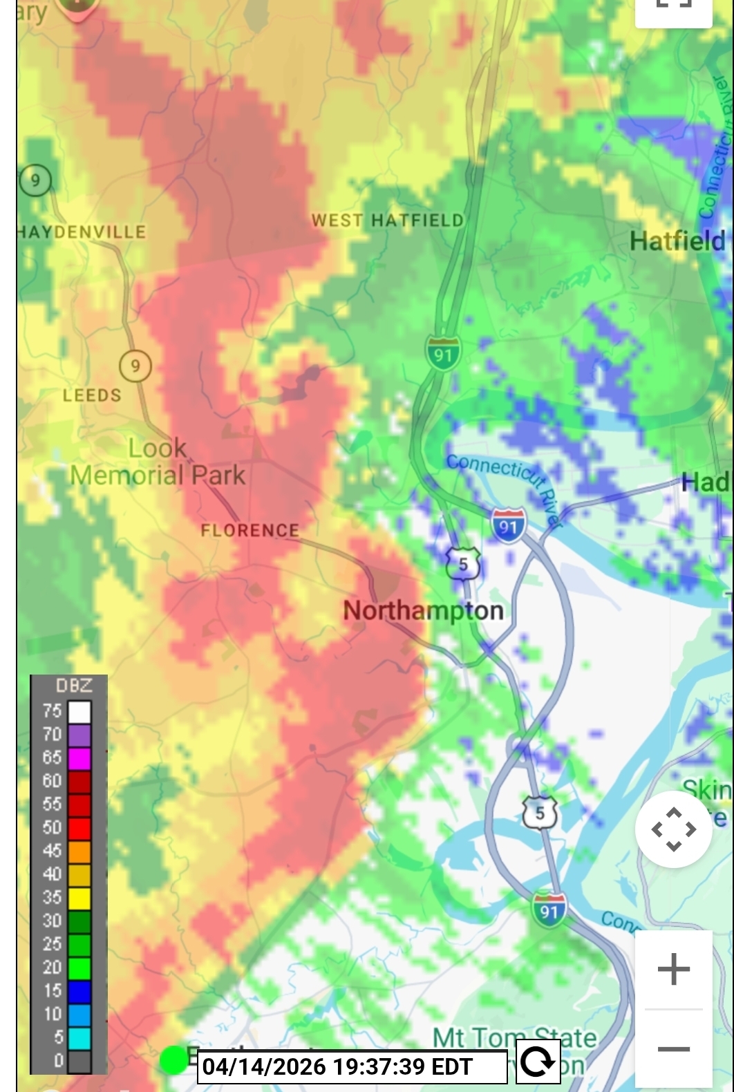
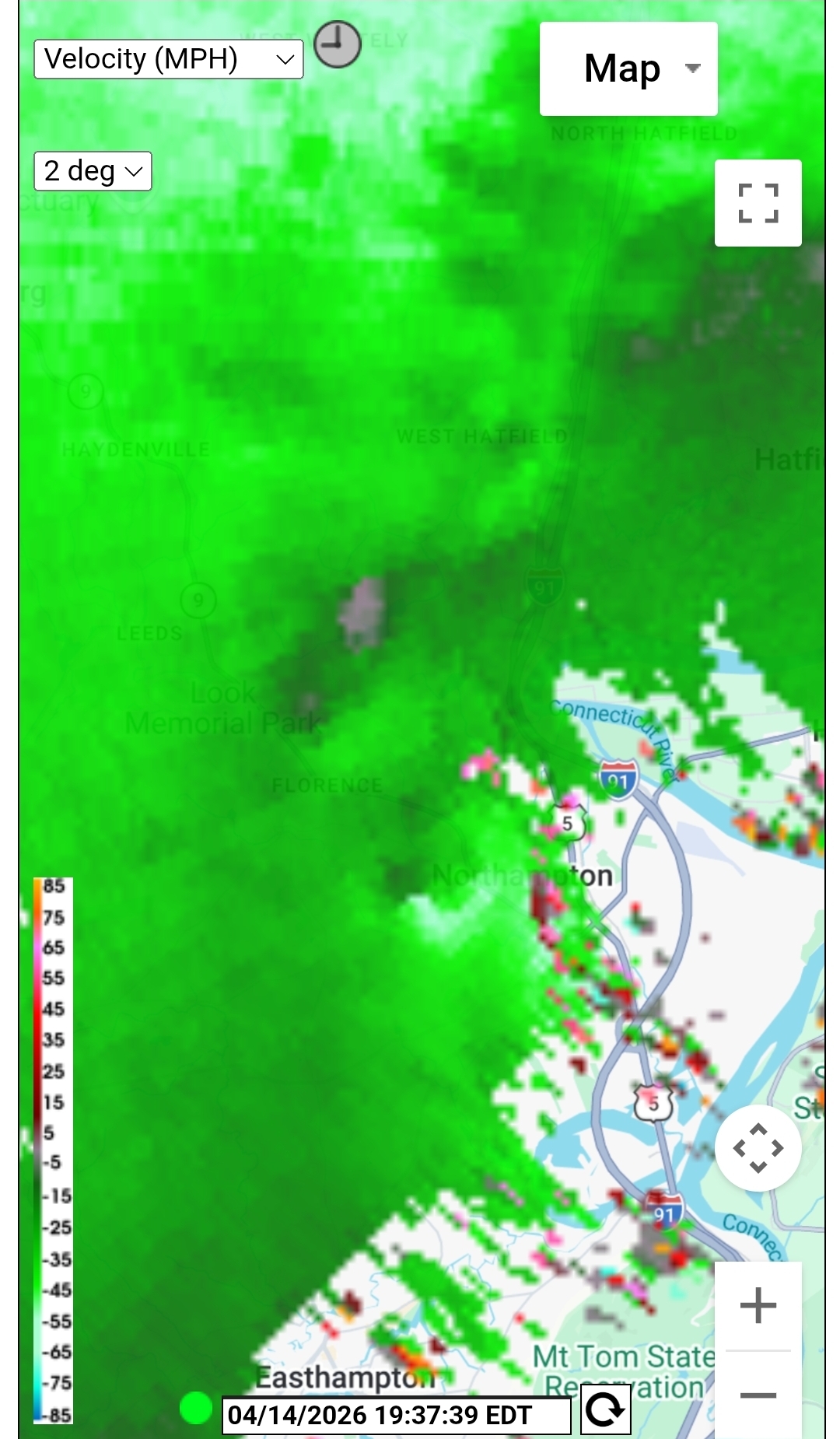
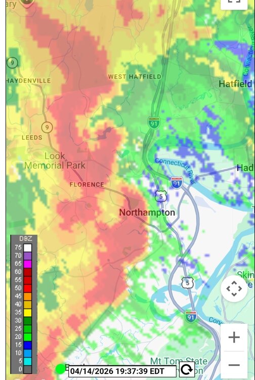
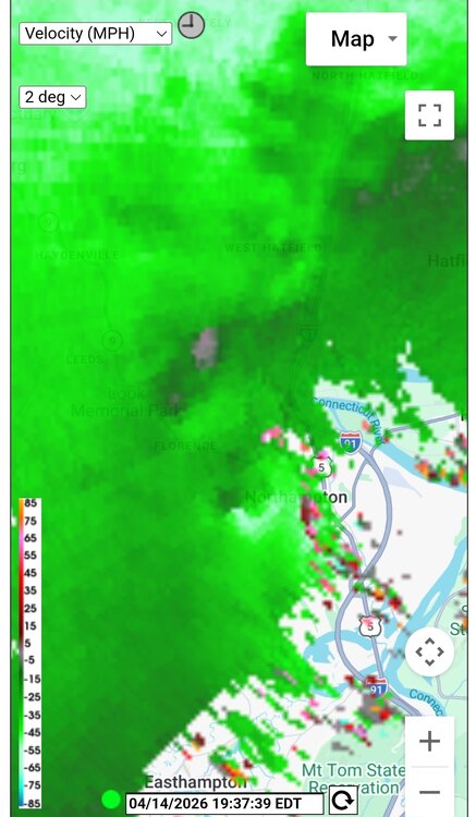
The UMass X band has been performing great of late after some upgrades. Nice to have some high res looks at convection again, this far from Nexrad. You can see the shear tightening up just west of Noho. Doubt this amounted to anything but still cool.
-
Was kind of meh. Good rain though for the plants.
-
There might be one near here because I am smelling smoke very strongly. Edit- 11 acres burned yesterday near the Amherst/Pelham/Btown lines
-
5/9/2020 had snow in Central Park, which is nuts
-
Stiff NW breeze off the water at Quabbin, and yet still a warm breeze
-
10M+ households ain't terrible
-
Heavy coating in Btown this AM
-
Nasty cold front after a glorious day
-
Fox Squirrel? https://en.wikipedia.org/wiki/Fox_squirrel
-
Was full on spring the last 24 hours, birds chirping, crocus and hellebores popping along with the dews, an altogether different smell out there. Was nice. Anyway sun's gone. We cloudy
-
thunder here
-
Gotta be a top 3 or 4 worst March Warm when we wanted it cold. Cold when we wanted it warm. And mostly snowless
-
It is low indeed. Also, as of Saturday, was still completely ice covered, at least on the west fork. I was surprised.
-
Like most springs SW is best
-
Hard pass on a 16+hr drive to chase linear mode low topped thunderstorms with fast moving embedded tornadoes. If you even see one you're probably too close. But take the drive out if it and of course
-
Decent snsh rolling through