MillvilleWx
-
Posts
5,530 -
Joined
-
Last visited
Content Type
Profiles
Blogs
Forums
American Weather
Media Demo
Store
Gallery
Everything posted by MillvilleWx
-
"Gentleman, we have won two games in a row. If we win one again, that's what's called a winning streak..."
-
I do feel the CAD lasts longer for those west of the fall line, but I also think the efficiency marker for this event is likely to be a little less than what the ECMWF is taking into account. This is a marginally cold enough air mass being forecast with wet bulbs at 27-31F across the region. Latent heat release will allow for temps to slowly rise during the overnight with most areas at freezing once we get into the morning. One thing to keep an eye on is rates as lighter precip will allow for better accretion efficiency and less opportunity for faster warmer due to those latent heat processes. NBM is basically half of what the ECMWF is implying, but is also a bit more in the sleet realm which would also cut ice accretion, but still be impactful. I think areas that have the best shot at >0.15" accretion at this juncture are areas >900' west of the fall line. Catoctins, Northern Carroll along Parrs ridge, South Mountain, and areas west of Cumberland. 0.05-0.15" for many others, plenty to make it impactful for restricting travel. I will say that if this busts, it might be more of a positive bust since the airmass is very shallow but still fairly fresh with the advection pattern occurring less than 24 hrs prior. We shall see!
-
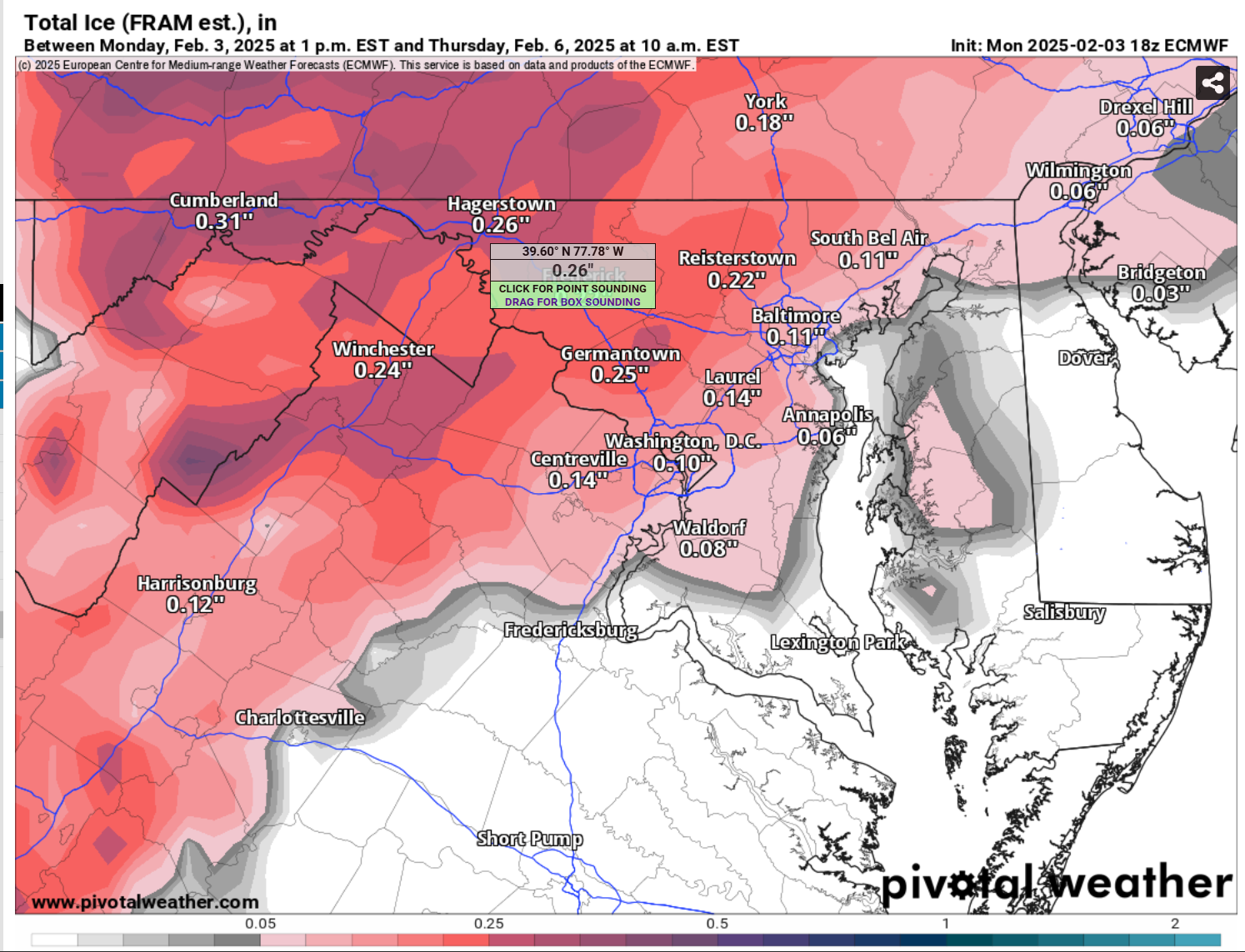
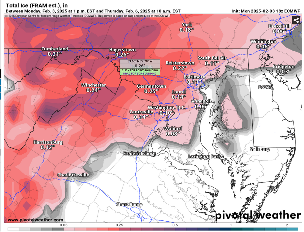
Still think this is a bit overdone, but still increasingly significant nonetheless. FRAM is what you want to estimated ice accretion. Accumulated Freezing Rain is just model output of QPF that would fall as ZR. It doesn't take into account other variables that provide more information on efficiency. Looking icy Thursday morning for many. Below is the 18z ECMWF FRAM output
-
I almost fell out of my chair
-
There's an article in the local Lancaster Newspaper about that event. It was incredibly wild to see.
-
Thank you for the kind words my friend. It was a pretty horrible month for me. Grandmothers funeral was Thursday with the viewing the day before. My mouth is healing fine, although had a scare and emergency dental visit that cleared me of anything bad, but have to switch from Sonicare tooth brush to a manual soft bristle until cleared. Ravens L sucked too. Just a brutal month overall. Hopefully February and beyond are better. I appreciate the thoughts and prayers very much, so thank you
-
One things for sure in this upcoming pattern, there will be a train of waves moving across the country into our neck of the woods. Thermal gradient placement and amplification regime once east of the Mississippi will be everything. Give us the cold and we will have numerous chances at frozen, whether it be in the form of all frozen or thump to flip remains to be seen, but both the GFS and ECMWF are now in tandem with the potential. Should be a fun pattern to monitor.
-
For the last 3 years I have been adamant that no one beats the Ravens like the Ravens. Holds true every year and it's incredibly annoying.
-
The fact we verified some of the insane totals the models were spitting out for days still blows my mind to this day. It was truly a marvel.
-
Well, ended up getting the tooth extraction yesterday afternoon and so far so good on the pain front. Just the standard post surgery pain. Ice and ibuprofen my bff’s. Resting. I’ll be back to normal soon enough. It did end up being a fractured tooth below the gum line that helped cause an infection. Got the tooth out and cleaned out the infection. On antibiotics for 7 days to clear it out completely from my system. Side note, nitrous oxide is some damn good stuff. Between that really good numbing, I felt asbsolutely nothing during the surgery. Probably the most relaxed I’ve been in over a month. Incredible.
-
Season Total: 11.9”
-
Man, I’m glad I saw that 10+” snow storm earlier this month cuz the start to this year has been absolute dogshit Rough storm today Ravens blow it Tooth needs to be extracted Grandmother dies Some other personal stuff Just freakin awful. My God. I hope the rest of the year is better.
-

1/19 - The Roulette Wheel 29 Black Storm - OBS
MillvilleWx replied to DDweatherman's topic in Mid Atlantic
All snow in Edgewater. Monster flakes after multiple rounds of heavy sleet mixed with snow. -
1/19 - The Roulette Wheel 29 Black Storm - OBS
MillvilleWx replied to DDweatherman's topic in Mid Atlantic
Absolutely dumping sleet and wet snow in Edgewater. This is the window for the lowlands. Should end well for the few hours it comes down. 34/32 -
1/19 - The Roulette Wheel 29 Black Storm - OBS
MillvilleWx replied to DDweatherman's topic in Mid Atlantic
Well, temps aside, the radar looks semi decent right now for what is expected. Final forecast does have some revisions down based on thermals NW of I-95: 2.5-5” max of 6” further north Along & SE of I-95: 1-3” South of I-66 Latitude: 0.5-2” Northern Neck Eastern Shore: 1-3” Sterling did a good job handling this one. The thermals ended up being RGEM like pre-storm despite it being incorrect on the SLP evolution. Hopefully I’m wrong, but this isn’t trending towards a good result unless we get absolutely blasted this afternoon. HRRR has been keeping this low key for several runs now which looks like it may end up being right. Globals were too cold at onset and skewed everything too snowy. Mouth still in minor pain. Just going to sit back and watch football and hopefully a good 2-3 hr snow period later in the lowlands. Good luck everyone. -
1/19 - The Roulette Wheel 29 Black Storm - OBS
MillvilleWx replied to DDweatherman's topic in Mid Atlantic
Could probably use Zelle Phone #: (281) 330-8004 -
1/19 - The Roulette Wheel 29 Black Storm - OBS
MillvilleWx replied to DDweatherman's topic in Mid Atlantic
Temp really crashed during this period of radiational cooling. 31/29 currently -
Well, went to an emergency dentist visit and found out my issue for the mouth pain. Fractured back right tooth on the bottom. It is under the gum line too, so without an X-Ray, there was no chance to know. Have to get the tooth extracted on Monday. At least I know the issue, even though it sucks. Hate mouth pain stuff
-
1/19 - The Roulette Wheel 29 Black Storm - OBS
MillvilleWx replied to DDweatherman's topic in Mid Atlantic
Be on the lookout for falling iguanas after your rain -
1/19 - The Roulette Wheel 29 Black Storm - OBS
MillvilleWx replied to DDweatherman's topic in Mid Atlantic
Forecast high of 45 only made it to 41. It’s currently 40/35 and cloudy. -
This forecast sounds extremely familiar….
-
Yup. I look at all the models like everyone here, but unless there’s some significant agreement within the ensembles and eventual hi-res, I will still go with the more trusted deterministic output than outliers. I haven’t wavered from my forecast for that very reason. Can’t be living and dying by every model run.
-
Reston is one of those tricky areas right in the dividing line of my typical main zones. I’d say 2-4” with upside potential 5” is probably a decent forecast for that area. There’s a little boom potential with this one for areas that stay all snow through the event, so it’ll be something to monitor.
-
I would say 10-20 miles outside beltways and 20-30 inside. Probably difference in areas >= 250’ ASL. I know I grew up in one of those areas that went from zero to 100 when it came to snowfall away from 95. Lived 8-10 miles west and went up over 280’ in that span. Crazy microclimates
-
No problem! I think that’s a result of the primary cyclogenesis with the low strengthening and creating a narrow channel of stronger 7H VV’s within the western flank of the circulation, proxy of 700mb low maturation. This is likely in combination with a strengthening CAA regime within the boundary layer allowing for maximum ascent between the 925-700mb layer. There tends to be a band that develops within that core during these types of regimes. Those are sneaky and can be a nice surprise for areas that miss out on the initial wave of snowfall. One of the reasons places like you mentioned into South Jersey can sneak into good snowfall totals.