

Cold Rain
-
Posts
23,935 -
Joined
-
Last visited
Content Type
Profiles
Blogs
Forums
American Weather
Media Demo
Store
Gallery
Posts posted by Cold Rain
-
-
3 minutes ago, Bryan63 said:
https://twitter.com/RaleighWx/status/1071117371224571904?s=19
Allan Huffmans latest thinking.
Don't be stealing MillerA's thunder!
")
-
The sun angle is about as good as it gets. So at least we got that going for us!
-
 3
3
-
 8
8
-
 1
1
-
-
Sure would be nice if we had an actual Arctic air mass to tap into. Maybe later this winter we can get a similar setup.
-
4
-
-
Just now, Queencitywx said:
Garbage. They are total garbage. I don’t get why anyone would use them.
I agree.
-
1 minute ago, downeastnc said:
Problem is the temps at the surface are 33-35 for most of that...according to that it even MBY would be sleet/snow most of the storm though with temps just above freezing...so might be one of those times where we get a quick 2-4" of slop with the heavy rates before it lighten up and goes to cold rain......
I would think that with the wedge and heavy snow falling, we'd hover around freezing or just below. But there's no way the column is going to be that cold. It will be really interesting if the Euro comes in similar. But I expect it will tick north, just like the others.
-
Looks like the 12z runs have generally ticked north. Was hoping to see southward ticks continue.
-
1
-
 1
1
-
1
-
 2
2
-
1
-
-
5 minutes ago, PackWxMan said:
Wow - thanks Fish. You just explained EVERY snow storm in Raleigh. Which ensembles is he referring to?
For those unfamiliar with Fish, he is typically the most conversative forecaster on earth
He LOVES the SREFs.
-
14 minutes ago, griteater said:
FV3 Loop

I love this, but there is no way that is going to be right. Oh how I wish, though.
-
4
-
1
-
1
-
-
1 minute ago, NCSNOW said:
Best or safe way for areas to luck up on the fringes is to root for the early thump. You can see column cool from top down at the beging as precip breaks out on most model runs if you watch real close. See 850/0 line push south.So if you can saturate and get a good burst , itll sustain itself and delay the changeover. If you get a virga storm then the opportunity will be lost and its straight to ice when things rev up and heat up above with SE winds, warm nose.
So you want deny the warmnose but ifbyou can delay it a few hours, then all want be lost and maybe at the end get a quick burst of an inch to whiten things back up.
Yep, good post.
-
2
-
1
-
-
Just now, Disco Lemonade said:
Wow wasnt expecting this
I’ll bet he was!
Looks good right there.
-
1
-
3
-
-
6 minutes ago, Brick Tamland said:
I don't think the warming aloft will be as bad as you think. I think we will get a good thump of snow like Allan said, 4 to 6 inches, before getting some ice on top of it.
Ok good deal. Why do you think there won’t be much warming aloft?
-
1
-
2
-
-
I think we can all agree that the extended ranges of the NAM are suspect and that it’s snow map on TT is ridiculous. But there is going to be warming aloft here. And it will be warmer and more extensive than the globals are showing. For many in central NC, assuming we don’t have a convection moisture robbing situation (which is possible), there is going to be a lot of sleet and ZR, even back into the Triad and into parts of VA.
-
1
-
1
-
1
-
-
4 minutes ago, NCSNOW said:
So you think Greensboro only gets 1 to 2 inches. Interesting
They're right on the 2-4" line. I can make that work.
-
1
-
-
1 minute ago, Bevo said:
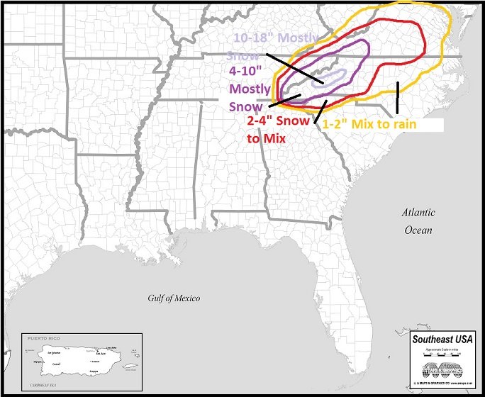
Imma need one of those sweet Cold Rain maps for clarification please...
I threw this down yesterday. Still looks good to me.
-
1
-
1
-
1
-
-
5 minutes ago, FallsLake said:
Hey CR, Look at how the 850 temps are trying to move back SW from Canada.
Click 4x back for "Prev. Run"
A few move movements back and we have a much better cold air feed.
Nice! Hopefully, that can work itself out before I throw in the towel!
-
2 minutes ago, Brick Tamland said:
Euro, UK, and CMC all look good. Not sure why people are saying they are showing less snow. Looks pretty consistent to me. It seems folks just don't want to believe the models because what they are showing is rare here.
What?? It's not rare at all for the models to show 6 inches of snow in Raleigh.
-
2
-
1
-
-
Just now, Cold Rain said:
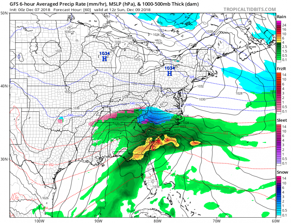
The Euro did for some areas, but as you can see from the data over the course of the last 12 hours, generally, we're seeing things like weaker highs, slightly north or closer to the coast low pressures, slightly less of a cold air pus, and of course, the snow maps are starting to respond by showing less snow and/or migrating slightly north and west. Not really any better trends today for the south and east edges.
And by the way, this is completely typical for winter weather around here. North and west zones are favored and should do pretty well. I believe we've seen peak snowfall maps for this one. For south and eastern areas, we need to see big time suppression 5 days out. We go through this every winter.
-
7
-
-
1 minute ago, lilj4425 said:
Warmer? I thought the Euro got colder???
The Euro did for some areas, but as you can see from the data over the course of the last 12 hours, generally, we're seeing things like weaker highs, slightly north or closer to the coast low pressures, slightly less of a cold air pus, and of course, the snow maps are starting to respond by showing less snow and/or migrating slightly north and west. Not really any better trends today for the south and east edges.
-
1
-
-
Ha they're going to beef it up after models come in with a warmer solution. Still looks to be impactful west of the Triangle, though.
-
1
-
1
-
-
We can play around with long range NAM soundings, but the trend in this particular model is to delay and lessen the push of cold air and the strength of the high. There's no question aout that, and it's not good. That doesn't mean it's right. And it doesn't matter if it's exactly right. But if other models continue this trend in one way or another, then we have a problem, assuming you like lots of snow and an all frozen event.
-
3
-
-
1 minute ago, Brick Tamland said:
Okay, so where is the info that shows they could be wrong? What is the other info that RAH is basing their forecast on right now?
You will know they are wrong when ice is forming on the trees in your yard.
-
2
-
-
3 minutes ago, Brick Tamland said:
It been is just hard for me to ignore the consistency and agreement with the various models. I know what has happened in the past, but we also don't usually have this much consistency and agreement with the models. They would all have to be wrong or start to do a complete 180 now.
They would have to do a complete 180 for what to happen? All rain? Not sure anyone is calling for that. It’s hard for me to believe that you have been following the weather for as long as you have and have as much faith in 5 day snow maps as you do, regardless of their consistency.
-
3
-
-
Go to West Jefferson. It’s awesome.
-
1
-
-
1 minute ago, downeastnc said:
Colder and snowier much further east.....now if it will just go ENE from there instead of reforming off the NC coast we would be looking at a bigger event for central and eastern NC but that little jump north kills us.....
It might go ENE for one more frame. I guess we'll never know.

-
1
-

December 8-10, 2018 Winter Storm
in Southeastern States
Posted
Better not. At 0z you will wish you had kept it!