

Cold Rain
-
Posts
23,935 -
Joined
-
Last visited
Content Type
Profiles
Blogs
Forums
American Weather
Media Demo
Store
Gallery
Posts posted by Cold Rain
-
-
Yeah, the EPS is looking pretty good out in la la land. Gotta look good out there before it gets in here, I guess. Hopefully, we will see several runs back to back with that look and have it actually progress in closer this time.
-
19 hours ago, NC_hailstorm said:
No need to be a smartass dude with your snarky remarks.
Why don't you move along son and let some of us observe and research things while you stare out your window and pray for snow.
Not at all. I don't understand the solar stuff or really know where to follow it. I just assumed based on your last post about the potential for solar winds increasing, that must have happened since the MJO was going to spend a lot of time in the bad phases. It is really looking bad right now in terms of the mjo progression and unending warmth. Not a shot at you at all. Just a reflection of me not understanding how the solar stuff really ties in and sad that it looks like it isn't going to help as much as it initially appeared. I've said many times (as have others) how we appreciate your posts and wish you'd post more about this stuff. Even have asked questions, but you hardly ever respond.
-
Man, those solar winds must be really smokin'. Going to from things looking ok to unending record warmth possibilities. I have to say, it's not looking good.
-
Looking forward to getting past the half-way point in Jan. Should see some signs of life showing up pretty soon. Somewhere near the beginning of H2 January, we'll be tracking our first legitimate threat.
-
 2
2
-
-
What a mess in the long range. All features are still basically opposite of what we want. How does that even happen all the time now? MJO looks like a disaster going into phase 5.
-
1
-
-
26 minutes ago, BristowWx said:
Not seeing it. Maybe I am not looking hard enough.
It walked away from the big wound up PV over the pole, a little bit, toward the end. Even looks to try to fire up a -NAO.
-
1
-
-
MJO looks to be setting up camp in the warm phases again this winter. Going to be a long wait, it looks like. Oy vey.
-
23 minutes ago, FallsLake said:
We'll be ok. At least cold is showing up. As many on here say, we got to get the cold first; then worry about moisture.
All the cold is going to be pinned up underneath the big AK PV. We need that thing to move. It feels like no matter what pattern we get leading into winter, we're always dealing with this no-blocking, big PV in the wrong location garbage during the heart of winter, while we wait for the supposedly better back half of the season.
-
4
-
 1
1
-
 1
1
-
 1
1
-
-
59 minutes ago, StantonParkHoya said:
Raleigh got 15.6 inches of snow last year and in January 2018, RDU spent a record 159 hours below freezing. Lakes and ponds throughout the state were frozen so thick, ice-skating was rampant.
I get what you're saying, but don't let recency bias turn into hyperbole. This is just a crap pattern.
Not trying to be hyperbolic. I forgot about that really cold snap we had. I think the winter ended up above average in temps, though, and the main snowfall events happened in January of 2018 and December of 2018. I tend to think of those as different winters, even though they're technically in the same year. I haven't gone back and reconstructed anomaly maps, but I'd guess that RDU has trended above average for most winters over the last decade. 2017 and 2016 were very meager in the snowfall dept at RDU. 2015 and 2014 were ok. I think these big -EPO patterns we've had with very little blocking (NAO) have kept things mixy and kept the timing window narrow.
-
1 hour ago, WarmNose said:
I think my rebuttal to that argument, just for arguments sake, is that our terrible last two winters have been salvaged by an early December miracle and that miracle didn’t happen for a 3rd straight year. Did we miss our opportunity? If we can’t manage a winter storm inside a winter month this year, like we couldn’t the last 2 years, then we get blanked. There’s reason for pessimism but deep down you have to think we can’t suck forever, right?
I absolutely get the pessimism. I feel like it's much harder to get cold and snow than it used to be. It's discouraging. At the same time, if you're really trying to understand the pattern or make a real forecast, you have to look at the data and let that be the primary driver. In all honesty, I don't care what happened last December or the one before that. It's a new year, and the weather doesn't know what it did last year. The general idea that it's harder to be below normal than above needs to be considered, but if the data are pointing toward a good winter or a good period, then that should be the overriding factor.
-
1
-
-
1 hour ago, mackerel_sky said:
It’s just the same old thing, I try not to wish/bittercast, but I’m great with average, and I get this year is “ better” so far, and I realize we live in the south, but it just seems like sound meteorology doesn’t work anymore. We can’t even get a week of temps below normal, but can get 1-2 weeks above normal, at the drop of a hat.
Sound meteorology does work. It's just that there's a lot of wishcasting that happens on message boards and in the Twittersphere that lures a lot of people to grasp at false hope. Last year, you could see going into January how bad things were and once we got into the second week of February, you knew that it was basically done, in terms of a sustained cold pattern. The other thing is, it's just easier to be warm than cold right now. Why that is the case is a whole other discussion. But regardless of the reason, it is just that way right now.
That said, if you look out and pin your hopes to a 240+ GFS snowstorm, you're going to be disappointed. But if you look at things happening around the globe and put those together with model output and incorporate an understanding of how models work and why they show what they show, then you can at least make an educated guess as to how things might shake out. None of that guarantees cold and snow, even if all of the weenies or "trusted sources" are honking for it...because quite frankly, there's a lot of mishonking that happens every year.
Hopefully, we know who's full of it by now and hopefully understand the biases of posters/professionals that we tend to follow.
-
3
-
2
-
-
17 minutes ago, mackerel_sky said:
Hard to get excited about a pattern 10-15 days away, when December looked great 10-15 days ago! Here we are chasing 50 degree rains, with suppression
I don't recall December really looking all that great, though. There have been a few windows where a well-timed, perfectly executed winter storm could have happened for parts of the area. But we have not been anywhere close to a legitimate winter storm pattern, outside of a few LR model panels, which hopefully we all know by now, we shouldn't get too excited about.
Here's what I don't get. I can't understand it. I've asked before, and nobody ever really answers it. Do we really not expect to see mild periods in winter? It is the SE. It's going to be mild some of the time. We just have to hope the pattern (which you cannot determine from one LR GFS panel or one ensemble plot) isn't a dumpster fire. The predicted state of the atmosphere in a couple of weeks isn't showing signs of being a dumpster fire. That seems like a good thing to me.
I'm not saying to get overly excited about a modeled 10+ day pattern. But by the same token, there's even less of a reason to be overly pessimistic about it right now. There is no rational reason, steeped in meteorology that would lead you to conclude we're headed toward unending warmth for the winter. The only reason somebody would believe that is simply because they just want to.
At the same time, there's no rule that says you have to be excited about a week two pattern either. I don't know why it's so hard to be neutral and approach the thinking and discussion by minimizing bias and maximizing critical thinking. If you do both of those things, there is real actual reason to be somewhat more optimistic than pessimistic regarding the extended range. That's just the way things are lined out right now. Maybe that changes in a few days. But now you are just guessing/wishcasting/bittercasting or whatever term you want to use.
-
9
-
1
-
-
42 minutes ago, WarmNose said:
The last several runs of the GEFS/EPS are a total dumpster fire in the medium and extended. I believe it gets worse before it gets better
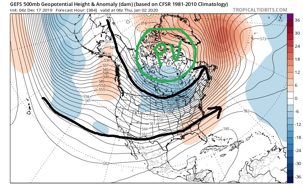
The extended gets into decent shape at the end of the GEFS. The trough in the SW is an artifact of a split stream. As long as the EPO region gets into shape, cold air can filter in. Notice where the PV is. Not in an ideal spot, but not too far away that it wouldn't take but a couple of very quick adjustments to kill the slight ridging in the SE. Even as things stand on that map, there's not any reason to think CADding wouldn't be an option. Anyway, my take is, we have been in much, much worse patterns than the one depicted. And what's being shown isn't a far distance from being able to produce bigly. I can't see the EPS that far out, but if it looks similar, than let's take our normal/above average period like a man and rock out in January!

-
3
-
1
-
-
1 hour ago, Tar Heel Snow said:
Or at least just straighten it out, that’d cut plenty of time off the Raleigh to Charlotte drive!
Anyway, it seems like right now, there’s still quite a few moving pieces but there’s certainly reason for cautious optimism and pessimism. Remember @Cold Rain’s “so what did we learn here?” thread
")
Boy, those were the days, huh?
")
This is such a marginal marginal setup that is really going to take a lot of work to even get a chance at shoehorning a winter storm in. I could see some front-end stuff near the mountains if everything went just right. But we really need a rapidly intensifying low off the coast for a more widespread show event for northern portions of the area. The cold is really not robust enough for a marginal system tracking way to the south. Like, I really like the tracks showing up at this lead, but man, the cold air is so....mild.
Edit: Not "show"..."snow" above. See, it's so marginal I can't even type snow.
-
1
-
-
41 minutes ago, griteater said:
The key idea of us moving to a cooler pattern was for the bulk of the closed low (or lobe of the Tropospheric Polar Vortex) over central Canada moving into southeast Canada. With the bulk of it instead moving to Alaska, we are left with a developing, mild, west to east zonal pattern. BUT, over the past few weeks, each time the models move toward a mild look in the medium and long range, they flip and move back toward a cooler look, and vice versa.

Yep, that last part there is an especially good point. I would be surprised if we torch for any length of time. Doesn't mean I can't be wrong, but things are acting very Ninoish right now. Lots of activity, lots of energy, lots of changes. The background seems to want to be cooler than recent winters, though. I feel like the intangibles are on our side this year. I think they will help as the Pacific improves. And...I think they will help the Pacific improve/not become dreadful.
-
2
-
-
2 hours ago, NC_hailstorm said:
Euro seasonal looks better today,this updates every 13th day of the month.Much better blocking showing up south of Alaska now,.Heights across the lower 48 much lower this was all in the 40%-50%-50%-60% above average(light/moderate yellow) in November.Better heights in Greenland this was all mostly 40%-50% below average(light blue) in November as well.
Thanks for posting. How's the solar stuff looking @NC_hailstorm ?
-
I don't trust the Euro being bone dry. Like was said above, the pattern is active. I know you can still get waves suppressed, but it's like it doesn't have anything there to get suppressed. The southern stream is strong, and I suspect the energy that will be there will be stronger than the Euro is seeing right now. OTOH, the GFS's and the CMC's timing is off, the GFS moreso. Speed the northern stream up on the CMC a bit, and you got something.
-
1
-
-
1 hour ago, weatherlover said:
Waiting on a thread to be made about tonight’s “ice storm”
Start it!
-
I like the fact that we are not seeing the prospects of an unending torch or stranded in the wasteland of a bad pattern that takes weeks to get out of. I'm not too excited for the 21st period right now, but we're in a pattern for the foreseeable future where a storm can pop up quickly. Timing will be key, as usual. But with the possibilities of real blocking forming down the line, we might be on the cusp of a really good window for big winter weather near or just after the flip of the calendar. Sure has a different feel from Decembers in recent memory.
-
2
-
-
If we get a couple of those massive highs to come down like the models are suggesting, and if they can hang on for a while without racing east, there will be a winter storm at some point. The STJ is active.
-
3
-
-
2 hours ago, AsheCounty48 said:
If it gives you any confidence, Robert is a full Gung-Ho on the pattern getting cold for someone in the east mid month.
Robert's bullish bias is probably near 80%. Good met and nice guy. But he definitely has a bias toward cold.
-
2
-
1
-
-
Happy Thanksgiving!!
-
1
-
-
13 minutes ago, Queencitywx said:
I would generally trust the NAM with this sort of scenario but I can’t find anything similar on any other model
3K not nearly as impressed. The WRF ARW2 (as if the ARW1 isn't bad enough, so they needed a second one) is similar to the 12k NAM. The GFS, CMC, RGEM, HRDPS, etc. are all out on this one.
Good thing is, if the latest LR data is right, we'll probably be able to legit start tracking stuff in a couple of weeks.
-
4
-
1
-
-
59 minutes ago, Ralph Wiggum said:
I'm not psu but one factor I noted in my outlook was for a split flow off the Cali coast with trofs establishing in the SW at times. It is worth mentioning that I dont see that feature becoming a persistent full latitude feature. If anything I believe this helps aid in stj energy undercutting the ML ridge on the West coast and as it ejects east in pieces will provide SWF/gradient overrunning situations for us and more specifically the OV as it runs between the SE ridge which will appear periodically and NS 500mb trof over the GL/NE. That look has been showing up on the LR ens for a few runs but as you noted...la la land for now and nothing I would be too concerned with one way or the other right now. More interested in how the HL players line up going forward the next few weeks.
Agree with this. Red flags go up when you start to see more full latitude persistence, as you said. You'd start to see a SE ridge reflection in that case. So far, we don't see it, which is cause for optimism.
-
1
-
Mid to Long Term Discussion 2020
in Southeastern States
Posted
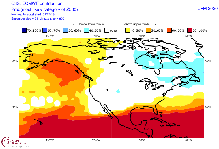
I live right on the boundary between the two darkest gray zones, right next to the SE county line. Yes, that map makes me want to vomit. It will play out exactly like that too. I don't know why there is always a poleward surge of the snow gradient right in that area. You would think that one time, it would be the inverse, just by the law of averages. But nope.