

Cold Rain
-
Posts
23,935 -
Joined
-
Last visited
Content Type
Profiles
Blogs
Forums
American Weather
Media Demo
Store
Gallery
Posts posted by Cold Rain
-
-
51 minutes ago, mackerel_sky said:
Anothe big rain cold event incoming! This may be a prolonged, extra cold rain event! Thu-Sat
Better than an extra long cold drought event!
-
Nice little chilly rain event. Good to keep the drought conditions at bay this time of year.
-
 2
2
-
-
1 hour ago, NC_hailstorm said:
MJO re emerging in the W.Pacific right on time(Nov.11-16th)with a big Arctic front entering the eastern US.Still think it keeps moving till around Nov.28th-Dec.4th into phase7,8,1,2 but as low as the solar wind has been this cycle I'd lean closer to early December but we'll see.
MJO should stall,weaken.or move to Maritime around Nov.28th-Dec.4th.There may be a relaxing of the pattern around and a bit after then then but the MJO should re emerge around Dec.6th-Dec.12th.December can be tricky if we get unexpected solar wind flareups like last year which in my opinion locked up the MJO in a warm phase longer than expected.
Also I'm watching the QBO closely,if that flips let's just say watch out.
Just my opinion.
Can you do please do these updates at least 4 times per week? Thanks!!
")
-
3
-
-
16 minutes ago, NCSU_Pi said:
OK, Nammer
Going to be an eye-strainer!
-
 1
1
-
-
Great read, Grit! I hope you bust too warm!!

-
5 hours ago, Solak said:
Gotta love the headlines this morning.
USA Today:
Next week's Arctic blast will be so cold, forecasters expect it to break 170 records across US
CBS News:
Americans prepare for Arctic blast
That's awesome. I think our area might crash all the way down to the upper 20s one night. A few days ago, I remember seeing a 12. Models seem like they might struggle by overdoing temps just a little bit in the long range.
-
6 hours ago, Buddy1987 said:
What's everybody's take. You rather have a front loaded winter and take your chances on the back end or have a crappy warm pattern front end and loaded back end? For me I'd rather take front and roll the dice on back end.
100% agree. Take it and run. All day long!
-
2
-
-
It is hard to believe that we will get as cold as the models are hinting at next week. Lows below 20? That would be a pretty amazing feat for mid-November. I bet we'll see some moderation in that forecast over the next few days.
-
4
-
 1
1
-
-
Fall is coming! Starting to look chilly as we roll towards Halloween.
-
1
-
-
20 hours ago, mackerel_sky said:
Patterns tend to repeat, even if they suck! Unless they are cold and snowy, then it’s a 1 and done 3 day stretch per winter!

Good. We'll expect the rainy pattern from last week to repeat over and over this summer!
-
48 minutes ago, jjwxman said:
Regardless, I'm not sure if I've ever seen wind speeds this high above the surface over NC. Incredible. Lots of potential, but like @downeastnc said the bust potential is high as well.
The winds upstairs are going to be at the upper end of what we usually see around here. RE: the NAM, I do not trust its depictions of CAPE or meso lows and such right now. It always looks scary severe weather-wise. I won't say there's zero tornado risk because we just don't know yet. At this point, what we do know is that there are some things look likely and some things look possible.
It looks likely that instability will be limited, due to an elevated warm layer and a largely overcast sky. It looks likely that there will be a lot of wind energy aloft that can be easily tapped. It looks likely that there will be a lot of rain, and the soil will be easily saturated. It looks likely that flooding will be a concern. It looks likely that even if winds remain below severe limits in most areas, downed trees would still be a concern, due to the aforementioned soil conditions.
It is possible that instability will be higher if breaks in the cloud cover occur (hard to tell at this lead). It is possible that a meso-low forms, backing the low level winds and increasing the tornado threat, at least for eastern areas. It is possible that convection earlier in the day reduces instability by the time the main forcing comes through, thus reducing the wind threat.
The main take-aways for me right now are that the potential is there for widespread wind damage reports, resulting from a squall line. There is not yet enough clarity or broad support to justify anything higher than an Enhanced Risk at this point, IMO. I certainly wouldn't be using the word "historic" yet. It is possible that things could change for the worse. But that is not the most likely scenario, based on the data available right now.
-
5
-
-
1 hour ago, jjwxman said:
For the Carolinas: I don't think we'll see a Moderate Risk. (but what do i know
 ) There are few things that will plague this forecast. 1st. The influx of tropical moisture will likely cause a warm layer around the 700-500mb level, this will weaken the mid level lapse rates. 2nd. The whole column looks very tropical, there will likely be a lot of cloud cover so CAPE will be limited. 3rd. PW values will likely be at record territory for this time of year, and with the slow progress of the system west to east, flooding will probably be the forefront of this event from training storms. I wouldn't be surprised to see some 2-4" rain totals in some areas. 4th. If we do see some sun and decent destabilization then this could turn out to be a significant severe weather event, particular for damaging winds, the hodographs are more elongated than curved, so the tornado threat should remain isolated in nature unless we get more backing from SE surface winds. A lot to decipher over the coming days.
Strongly agree with all of this.
-
2
-
-
2 minutes ago, frazdaddy said:
Nada, < 1" of slop
Same here. Thought you would have done a bit better. Maybe we can get a March Miracle.
-
26 minutes ago, frazdaddy said:
I'm in when #JBurns sees flakes.
How much did you get in December?
-
1 hour ago, FallsLake said:
Yeah until this year, a storm showing at this range would really peak the interest. We've even created storm threads for day 7 storms. But this year, I'm not sure when to take storm threats seriously.
12 hours still might be a bit early, but it would probably be at least within the window of appropriate lead time for a thread this year.
-
1
-
-
35 minutes ago, FallsLake said:
I love it. The models (6z FV3 and GFS) wants to give us the middle finger for one last time this season with a day 7 fantasy storm.
6z FV3:
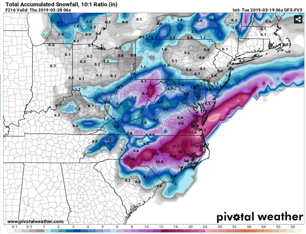
That’s awesome. Will we finally be able to get one stick around till the100 hour mark?
-
Saw a couple of flakes on the way into downtown Raleigh this morning. Of course, that's not all that unusual for a drive in.
-
1
-
2
-
-
2 hours ago, wake4est said:
We got like .5" of sleet where I am. No snow in it.
It snowed a bit here in SE Wake and then went to sleet then rain. We got about an inch of slush. That was it for the winter.
-
23 minutes ago, mackerel_sky said:
It’s a sad winter when the highlight was watching sleet pellets mix with the rain for 3-4 hours with tens at 36 degrees!
I saw 10 minutes of snow in the December storm. Unfortunate that we couldn't buy any cold this year.
-
 1
1
-
-
Hard to get too bullish yet, given our history of watching 7+ day threats warm up on the way in. But we're in the final innings and the signal is strong for a storm. Hopefully, it won't trend north too badly.
-
1 hour ago, frazdaddy said:
The evil twin (FV3) says huh... what storm?
Yep. That said, it is a piece of junk. Hopefully, they take it back to the workshop before they put it on the open road.
I think we will have at least one more legit shot before all is said and done this year.
-
1
-
-
Greg Fishel out at WRAL. What a miserable way to end a miserable winter.
-
33 minutes ago, Waiting on snow said:
I wonder if the SER isn't more of a pattern driver than a result of other teleconnections? I mean we look for ridging to develop over AK, Greenland etc. to drive the pattern. I wonder if ridging in the mid latitudes plays a significant role also? If sea surface temps are the reason for that ****ing ridge year after year I fear we are in a downward spiral toward a permanent SER because we cant stay cold enough long enough to bring sea surface temps around the SE down.
I don't know for sure, as I haven't researched it. When I look at a SST map, though, in general, there are plenty of places with warm anomalies that do not have ridging being continually forced. My guess is that the SER is a response. I'm sure there are some feedbacks at work, but generally, it is a response to the placement of negative anomalies elsewhere. What has been somewhat curious to me has been the frequency of the -EPO pattern in winters of late. I don't remember hearing all that much about that index before 4-5 years ago. But we sure have had a lot of -EPOs and an astonishing lack of -NAOs over the last while. This repeating configuration has certainly favored more central areas of the US than the SE.
I don't have a sense as to how the PNA has acted over the last 5 years or so...I am remembering it being mixed, but it certainly could have been more positive or negative in general than I remember. What I do remember is not a lot of deep south and southeast snowstorms. Instead, we get this gradient pattern and front end mix events. I think that is a product of the EPO and lack of NAO. We don't get those southern sliders with cold highs to the north anymore. Everything reforms or cuts, courtesy of no blocking.
But back to the SER, it really hasn't been a stable feature over the last several years. The thing that stings this year is that nobody saw it coming -- nobody really saw a -PNA/+SER back half of winter. I guess "backloaded" just don't mean what it used to. And by the time we're able to break the pattern, it will be beyond the reasonable window for winter weather, most likely. The GEFS and EPS look horrific as far as the eye can see. SOI diving, MJO allegedly circling favorably, but nothing but SERs down the line. We only get two, maybe three months of the year where we can be in winter weather mode, and to waste more than half of it in -PNA purgatory is really disappointing.
Unless something drastically changes, this will go down as the worst winter ever for me. I'm sure that I've had 1" of snow or less in the past, but the expectations going into this winter are weighted heavily in my mind. We have had no really wintry days. By that, I mean one where we had a snow, sleet, or freezing rain event where it was just solidly below freezing all day and you didn't have to worry about the temps. I mean, we haven't even had a clipper come through forcing random snow showers. It's just been an awful winter. Solid F.
-
There are pretty much no indications in any of the modeling over the next 10-15 days that suggests a turn toward colder weather. By the end of that period, the pattern may begin to change. But that is still far from certain. Whatever is driving this train wreck is locked and loaded for a long time. By the time we turn, it will likely be later in March. We may still sneak through a well-timed event, but you might as well flip a coin. All these intermittent colder solutions 6+ days out end up being warmer as you move in. Without a true pattern change, I a fear the chances of a big winter storm around here are slim to none. The SE ridge looks to really flex in about 10 days.
-
1
-

Mid to Long Term Discussion 2019
in Southeastern States
Posted
I thought the same thing. It's a misleading tactic designed to be click bait.