

Cold Rain
-
Posts
23,935 -
Joined
-
Last visited
Content Type
Profiles
Blogs
Forums
American Weather
Media Demo
Store
Gallery
Posts posted by Cold Rain
-
-
Looks like a quick reload. 6z FV3 setting up cold again at the end.
-
9 minutes ago, WeatherNC said:
Watch us get the coastal but miss out on boundary layer temps. I just don’t see how it will be cold enough for anything but rain, height falls in whatever semblance of a conveyer are not sharp enough.
May get enough dynamic cooling. I hate relying on that. But we haven’t really had many opportunities this winter. This one will be close. I’m normally a cold first guy, but since we have to work with what we got, I’m all for getting the precip in here and rolling the dice. Boundary temps look ugly, though...no arguing that.
-
 1
1
-
-
14 minutes ago, downeastnc said:
06Z Rgem looks good temps in the mid 30's has the low much closer and moving more NNE has precip way further inland.....starting to think this could happen.....

50-100 miles NW over two days. When does that not happen? Lol. If I was in downeast, Shaggy, and weatherNc country, I’d be super excited! Maybe even eastern Wake could end up picking up a sprinkle.
-
4 minutes ago, cbmclean said:
Somebody please tell Cold Rain to lower the dang snow shields.
Falling snow is the only thing that impacts snow shield strength, unfortunately. Also unfortunately, the 0z Nam did us no favors. You usually get one Nam run that sucks you in with heavy qpf or favorable trends. The 18z was probably it. But then again, maybe the 6z bounces backs. We’ll see.
-
Just now, mryanwilkes said:
Which potential threat is this one? 4 days out?
Sunday night/Monday-ish.
-
One thing to note, the NAM has been behind quite a bit here, so it's kind of playing catch-up. Need to watch the FV-3, UK, and Euro. Maybe the GFS and CMC after that.
-
Column is cold, guys. Surface layer is above freezing, initially. Unless you get a coastal hugger or inland tracker, you won't have to worry much about a warm nose. Probably won't get that far west, though. Light precipitation will probably be rain. Heavy precip will most likely be snow. Still too close to call either way, but the trends have been pretty good. We're running out of time, but it's good that things are quite close to something as opposed to needing a 1000 miles of corrections.
-
1
-
-
56 minutes ago, shaggy said:
Anyone else questioning the story of the missing 3yr old boy in craven county? I know 2 guys that went down to help search. They both said their were hundreds of people looking. Multiple helicopters including 2 state trooper ones with FLIR and 6 trained dogs that never struck his scent. He was found only 1/4 mile from his yard. Seems that many people,dogs and helicopters would have seen or heard him. Add that he was found following a "tip" it all seems odd.
He went missing Tuesday wearing just a jacket and was missing for 55 hours? 12 of those hours were below freezing with 4 hours in the teens. A 30lb 3 year old surviving that is either the most incredible story or there is something amiss here.
I saw that too. Doesn't add up at all.
-
A few more tweaks in the right direction is going to make a huge difference in the ultimate outcome. It is really that close in the upper levels.
-
1
-
-
11 minutes ago, Akeem the African Dream said:
wake me when some of these runs show frozen precip into florida
otherwise this looks pretty boring
Need to wait till the pole shift completes.
-
 1
1
-
-
7 minutes ago, Waiting on snow said:
Yeah it's probably not a complete shutout pattern. But once it relaxes is when I'd expect a shot. Until the end of the month I'd say the coastal areas have a better shot of a late bloomer that inland areas. The EPS generally keeps the ridge out west and trough in the east all the way through now. But we really need the STJ to crank back up because depending on the northern stream is just asking for disappointment. Lol
It's trickier to put together a storm in the SE than to have one tracking across the entire southern tier, where we can watch it all the way in. But like Gboro said above, the southern jet probably isn't going anywhere. The Euro books the MJO through phase 6 now, and even the GFS is perking up in that regard. I don't see us transitioning away from a cool/cold pattern for too long. And with all of the various shortwaves moving through, we could pop a storm at any time. It's the type of pattern where you likely won't get a lot of lead. I've been burned so many times over the last several years relying on northern stream stuff. Missed storms to the north, west, south, and east. But that said, there's no good meteorological reason to be overly pessimistic here.
-
3
-
-
I don't see how we can say definitively things are shot for the next two weeks when there is a good deal of cold nearby and a lot of energy in the flow. That doesn't make sense to me. I agree that this isn't a blockbuster winter pattern, but winter weather has been found in more hostile patterns types than this.
-
2
-
-
32 minutes ago, FallsLake said:
The PNA looks to go negative in the medium range but does jump back neutral/positive in the LR. The AO stays strongly negative. I wont even comment on the NAO.
I'm afraid that the cold will start dumping in the west and keep us in the rain/cold/warm up/rain/cold... pattern.
Not sure what the EPO is doing (site I use is down.....Budget). That could help us if it is negative.
Somebody with EPS access can hopefully eyeball it and tell us what the EPO looks to do in the LR. It looks to stay negative through D10 looking at the Euro Op.
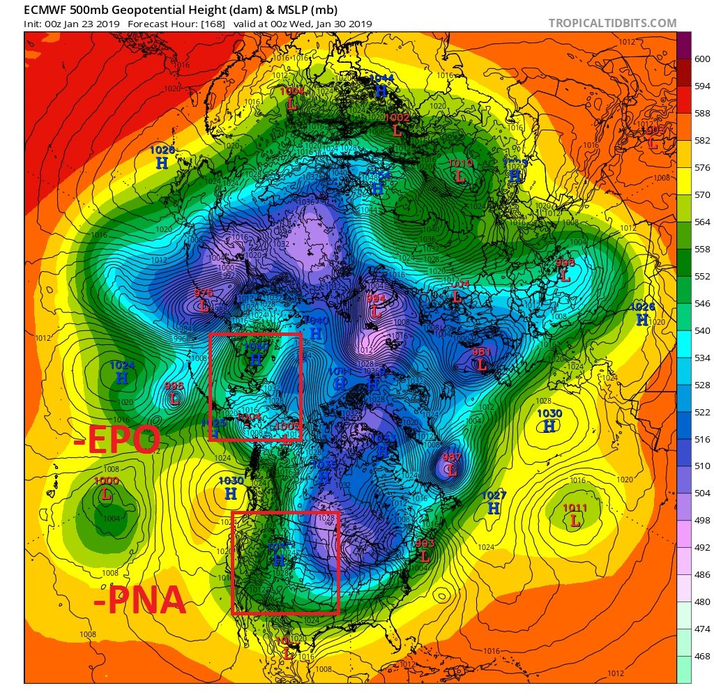
At 168, the EPO isn't configured in an ideal fashion, but my guess is that the calculated value is still negative. The PNA value is likely negative also. Either way, the configuration of the atmosphere isn't conducive for max cold and a super suppressed storm track in the SE. However, there is enough ridging in eastern Canada to push the PV south. Probably a cutter or Miller B pattern. But not warm:

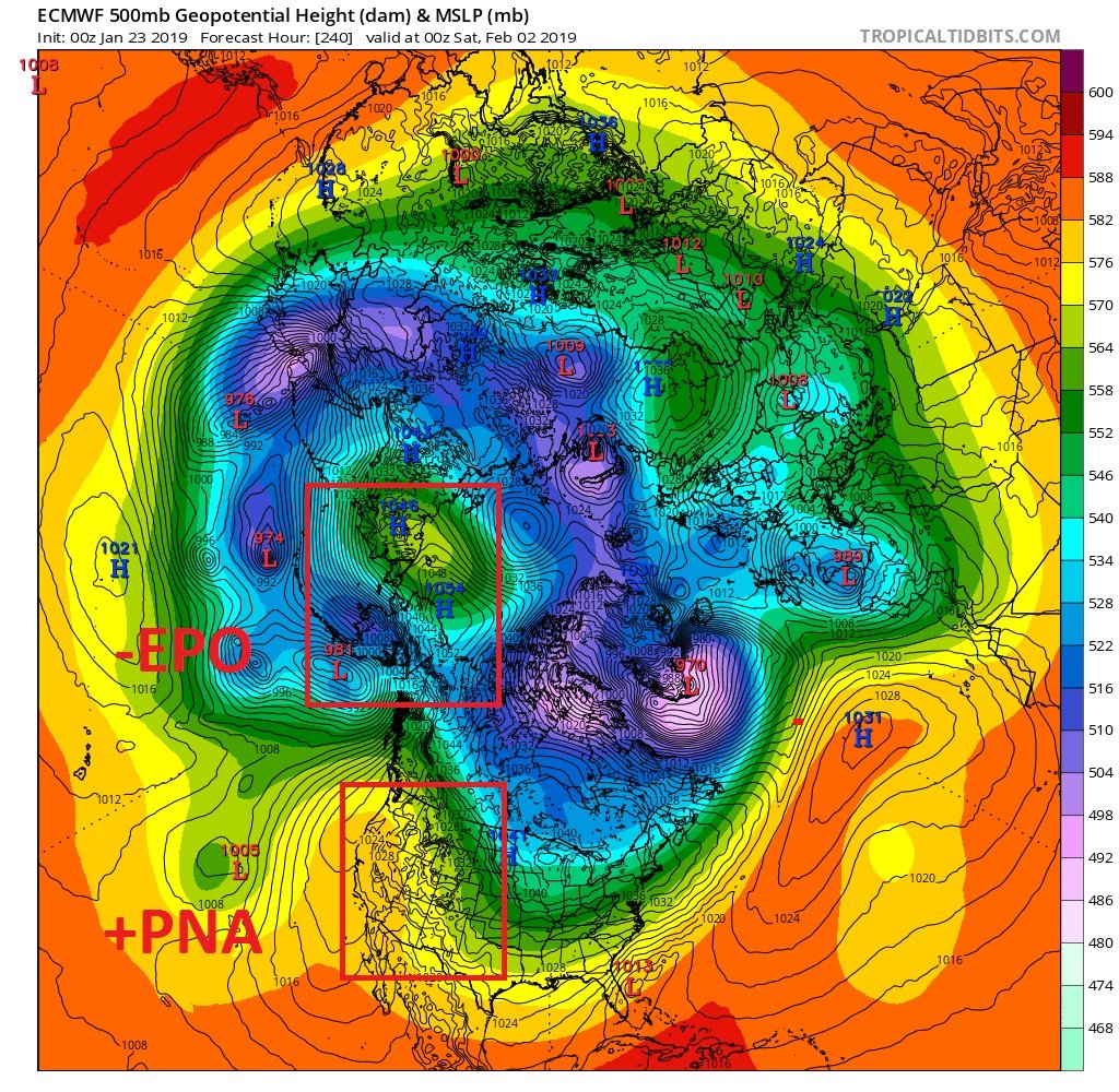
At 240, the block north of AK has strengthened, and it looks to be trying to connect with the ridge that has now gone back up over the western US. This would keep the SE cold and hopefully give more of the area a better shot at winter weather, eventually, particularly if the NAO region would respond a little. If the model went out another couple of days, you'd probably see colder values work SE:

Anyway, it's not an incredibly useful exercise to analyze a 10 day model. But this doesn't look too bad for an MJO in Phase 6 or whatever. Someone with EPS access can confirm whether this solution is supported by the ensembles and what the next several days after might hold. Overall, I'm optimistic on how the rest of winter plays out, pattern-wise. While I don't think we ever come close to getting the holy grail pattern, we should have several more legitimate opportunities to put something together storm-wise. The ingredients should all be available, and we should avoid utter hostility. Whether or not we can put them together remains to be seen.
-
2
-
 1
1
-
-
There's plenty of potential in the pattern over the next 10 days or so. We probably relax for a bit after. I suspect it will be short-lived before turning colder once again with another couple of opportunities.
-
Yeah I think we can safely say that after a week or so of below normal, the pattern is pretty much going back in the crapper. Maybe by late Feb, we’ll have another shot at a cold blast.
-
19 minutes ago, WidreMann said:
The models have vaccilated over that recently. They actually seem to have moved back to keeping the pattern in place. As for the MJO, it's pretty disappointing. The Euro is more aggressive in moving it eastward, so maybe it'll hit 7/8 by February and then we will have a favorable pattern for the month. GFS always sends it into the COD too early.
Yeah pretty much. There’s been quite a bit of run to run flipping. The earlier GFS, for instance had a big time -NAO. This one, not so much. I’m not sure the pattern is going to turn favorable and then break down immediately, especially if we can get the mjo into the better phases.
-
1 minute ago, Queencitywx said:
Coldest I’ve ever seen. It’s not even close.

That would translate to some chilly surface temps. I doubt the magnitude of that kind of cold around here. But still, having an expansive arctic air mass in the vicinity, with a nice snow pack to the north, will definitely widen the window for some wintry weather around these parts.
-
6 minutes ago, mackerel_sky said:
Hope the players on the field, play better than Alabama!? Would hope they don’t pull a fake punt!
Or the QB doesn't get ousted for point shaving.

Things do look to be aligning better now, though. At least cold is showing up frequently in the pattern now. And it would be hard to believe that storm chances dry up, as active as things have been.
-
1 hour ago, FallsLake said:
If I remember some of the discussion on the above indices, a -PNA is not bad if we have the AO, NAO and specifically the EPO on our side (all negative).
Usually when I see a -PNA I think we're done for...
1 hour ago, SnowNiner said:Yeah, I think the PNA goes a bit negative/neutral because essentially there's no ridge on the west coast. I could be wrong through. There's basically a full conus trough as all the ridging is up top. I think in that instance it's a good thing. The vortex is displaced into SE Canada and suppresses the flow so everything's going to come south, with a good feed of cold. All the other indices therefore offset the lack of a west coast ridge. Really like what the ensembles are selling for very end of January to start February. Like Matt said, it looks good. I don't know if it's ever been better? And it could last well into March potentially. Just have to wait another week or so and we should start seeing the models light up in the medium to long range I bet.


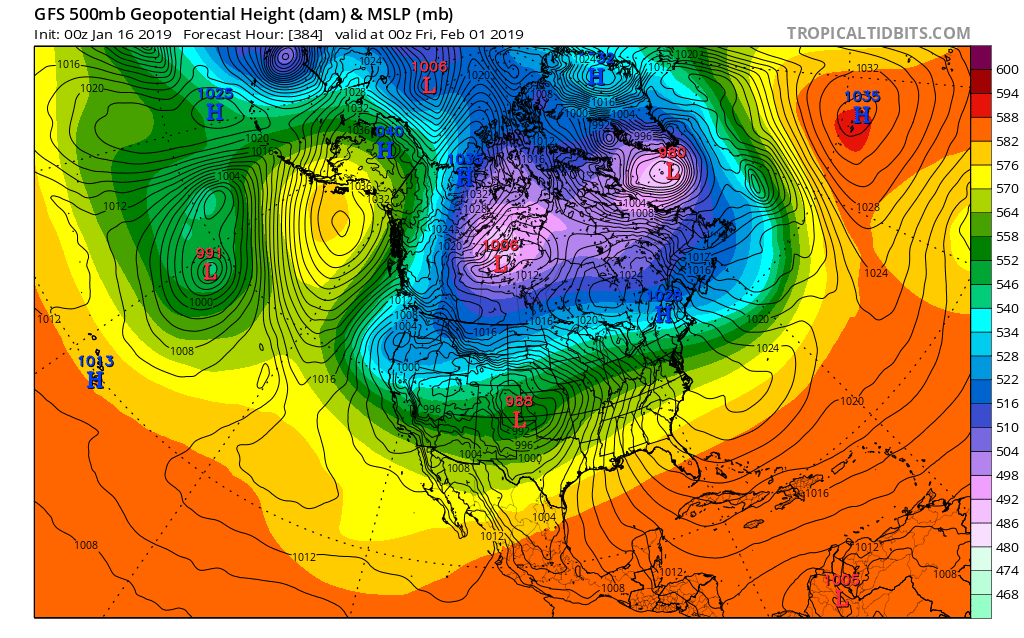
You do NOT want energy to start getting shunted out into the SW and off the west coast, causing a trough out there unless you have a big time west -NAO pressing the vortex south. You don't want it split either, having a piece over western Canada and one over eastern Canada with a weakness in the middle for storms to work into.
This is not a good look at all. Fortunately, it's the 0z 384 Op GFS. So it's unlikely to evolve this way.

The 6z looks like this. Even worse:
.thumb.png.7e130c2ca9d3973dab53c4ca03a6209e.png)
-
2
-
-
13 minutes ago, NCSNOW said:
Where have all the clippers gone to this winter? Be nice to see one when we are at max suppresion. Those are the only ones we can get to halfway work east of the apps. The ones that go down into Albabma, Georgia underneath the NC 6,000 ft peaks, then swing back up off the coast.
Yesterday's 12z FV3 was about as good as it gets from about 270 on, in the way it evolved the pattern. Today's guidance, virtually across the board, is to back the western ridge out west and sneak energy into the SW. If that turns out to be accurate, and I'm not saying that it is, that puts the storm track west of us and puts us back into a holding pattern, waiting yet another few days to get a better trough/ridge alignment and/or blocking. All of that is allegedly coming.
-
1
-
-
6 hours ago, YetAnotherRDUGuy said:
Frank Deal was one of the greats. I loved his enthusiasm for weather, and I felt like he really influenced the other young mets that worked for him in the late 80's/early 90's. One of those was Van Denton, who obviously took over after he retired. The other was a young Eric Chilton, who went on to become the head met at WFMY.
I'm not sure if WGHP was just as good as WFMY was back in those days--despite what the ratings might have been.
Also, RIP Frank Deal.
Frank Deal was the best. His jokes were so corny, but he was such a likable guy and loved winter weather. Couldn’t wait till the weather came on. Randy Jackson wasn’t nearly as enjoyable to watch, IMO, but I’m sure he was pretty good.
-
3
-
-
9 minutes ago, Bob Chill said:
FWIW- 12z EPS has sped up the flip to a -NAO by about a day... It's less than 15 days away. Starts building d10 and goes from there.
Thanks, Bob. That's cool...it usually goes the other way.
-
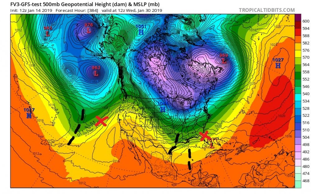
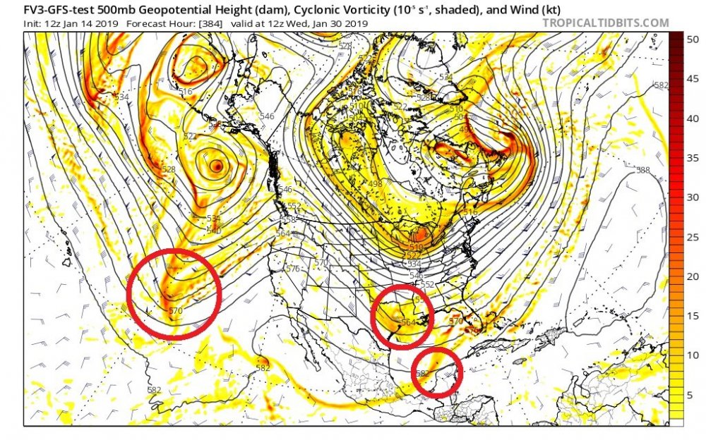
Good question. It's somewhat subjective, but it's pretty close. In the first image, the black lines represent the upper level shortwave energy in the southern jet stream. Usually, a low will form out ahead of that energy, north of the base. In this case, I'd expect surface reflections of various strengths somewhere near the red Xs. Even if no strong surface low forms, the upper level energy depicted here could still provide enough lift for precipitation. The second image shows the shortwave energy more clearly. I've circled it.
It's a long way out, and who knows what the energy will look like in terms of how strong it is or how it will be oriented. But the pattern is a good one, and if it turns out to evolve that way, you can bet that there will be energy flowing through the pattern. Let's get the pattern to move into the short term, and we can start to look more closely at the shape and strength of any shortwaves that are there. Hope this is helpful.
-
2
-
1
-
-
I like this look a lot at the end of the FV3. This is what we want. Usually, these aren't worth looking at. But given where we *should* be headed, we'll probably see more of this type of configuration showing up:

-
3
-


.png.d77c312cb8aca8e28ecdf9c8535da716.png)


Mid to Long Term Discussion 2019
in Southeastern States
Posted
Is this like 4 Ninas in a row then?