

Cold Rain
-
Posts
23,935 -
Joined
-
Last visited
Content Type
Profiles
Blogs
Forums
American Weather
Media Demo
Store
Gallery
Posts posted by Cold Rain
-
-
Just now, wncsnow said:
It is suppressed not even getting much moisture into Southern VA and not near as much as other models into the triangle

Thanks. It'll be interesting to see how far east it gets with the snow line. I expect the precip will be farther north than that. I'm much more concerned about the cold air.
-
Anyone got the UK snow map?
-
I feel like a lot of times, the models underestimate the strength of waves coming ashore from the Pacific, due to the lack of data in the region. The often tend to verify stronger when they move ashore, which may have implications down the road.
-
 4
4
-
-
8 minutes ago, jjwxman said:
12z EPS: You really can't ask for much more than this at this stage in the game. Roll on!

The placement of features is about as good as it gets for the upper SE. Unfortunately, as ILM said, the air mass isn't extremely cold. That's fine, if everything is perfectly timed. Just cold enough is still cold enough for snow, just like extreme cold is cold enough for snow. The issue is, you have less room for error when temps are 1 degree below freezing at key levels. Also, those highs are pretty weak. When you're dealing with marginal cold, you need all the help you can get from a strong high pressure. Hopefully, the timing can work out. Anyway, I like the placement of the key features. And I stick with my motto of getting cold first, then worrying about precip.
-
5
-
-
We want to see strengthening high pressure as we move in. Not the typical weakening.
-
2
-
-
3 minutes ago, eyewall said:
It was 5"/hr and it was insane. I believe we had 9 inches in 2 hours.
That's pretty amazing. I have never seen snow like that in person. Your pic is one of the snowiest pics I've seen. I'll bet that was so fun.
-
5 minutes ago, eyewall said:
If it verifies. It could end up easily putting me in the sanitarium lol. I miss snow already, and in VT they have had an epic November. I am just happy I was there for the Pi Day event in 2017 with my first ever 30 incher:

What would you guess the rate to be in that first pic? Looks like about 3"/hr at least.
-
1 minute ago, AsheCounty48 said:
Do we even use the NAVGEM anymore? Anyways, we are now getting closer to it's use, and at hr 144 it has the low substantially farther west than the GFS and Euro. The Euro is a tad closer.
Sure, if it's showing snow. Otherwise, it's a horrible model, and I would suggest tossing it!
-
5
-
 8
8
-
 1
1
-
-
6 minutes ago, pbrown85 said:
Is this the first big winter threat that the FV3 has done for this area? Or does it have an established track record?
Its snow maps have an established track record of sucking. But it's skill seems better than the regular GFS, overall. Honestly, there are too many factors for any model to have a lot of skill at this lead. Best course at this point is to look at the range of possibilities, compare to analogs, and blend in climo. A good winter storm is possible, but we need to observe trends over the next 3 days or so before we can legitimately hone in on who gets what.
-
2
-
-
I’ll take my few sleet pellets and extensive rain cold and like it!
-
5 minutes ago, FallsLake said:
Day 10 on the Canadian has a good cold setup. Looks like coast to coast cold with a pattern that could produce a SE winter storm. Who knows..
It's a cutter pattern. Trough axis is mainly in the west and tilted back toward the SW. You have a decent look for AOB normal temps in the SE, but if a storm forms, it's a cutter. No confluence in the NE, no blocking, main trough too far west, etc. GFS actually looks a little better at D10. What you would want to see in this pattern is a trailing wave after a rainer which develops on the tail end of the front. Then, we could get a little something.
Regarding the general pattern progression, there really isn't anything that suggests December is going to go warm in the means or feature a complete lack of winter weather chances. Most forecasts that I saw called for the month to be warmer than normal. So this notion that winter forecasts are busting all over the place doesn't really hold water. If there is anyone expecting December to be cold and snowy all through the month, then their expectations are way out of whack. There isn't anything that suggests an overly cold or warm month right now. And I haven't seen any patterns yet show up in the models that are of the torch variety and that can't be pretty easily fixed. Sometimes, every variable is wrong. That takes a long time to work out of. That is certainly not the case at this point. December should be variable, with maybe a slight lean toward cooler than normal. That's my guess.
-
1
-
-
Just now, cbmclean said:
?
People already hanging off the edge of the cliff with one hand on November 26. I could see that maybe, if we're staring down a torch at the end of December after a mild month. But on 11/26????!! That's definitely funny.
-
5
-
1
-
-
Hahahaha
-
2 hours ago, mackerel_sky said:
Euro weeklies really, really suck! They are hardly ever right!
Thursday called and wants it’s breaking news back!
-
15 minutes ago, FallsLake said:
I thought a gulf of Alaska low was good. It helps establish a western ridge.
No sir. GOA low bad. Fast Pac jet slamming right into the NW coast. Floodgates open for mild Pacific air. A better feature is the Aleutian Low.
-
 1
1
-
-
1 hour ago, mackerel_sky said:
Well the 12z GFS, is not worth giving thanks! That was ugly!!
That’s why you should be thankful there is a fake version! It’s better.
-
1
-
-
Happy Thanksgiving, All!
-
2
-
-
55 minutes ago, mackerel_sky said:
It’s the South, we take whatever small chances we can, no matter what time of year! I get as excited about a sleet pellet in November , as a full blown blizzard in February! The chances of either , are 0.00013%!

I hear you. I’m not poo pooing the chances of snow or sleet. I’m just saying what would be an awesome to have later in the winter. Where we might squeak out a little surprise ice pellet now, we would clean up later. That’s all I mean.
-
1
-
-
1 hour ago, mackerel_sky said:
If you say the same thing, one more time!!! We get it! Everything is greater in January and February! You’re starting to look like Brad Fanovich
I thought it was a reasonable point.
-
1
-
-
Bring that same setup slightly farther south, later in December, and we’ll be in business big time.
-
2
-
1
-
-
Clicks man, clicks.
Social media is pretty much a competition for clicks and likes, unfortunately.
-
1 hour ago, DixieBlizzard said:
So, Glenn Burns throws this on Facebook last night. He can't even get his description right (Calls colder temps a "blowtorch") and doesn't give any explanation that this isn't an official forecast. I thought @Lookout would appreciate this.
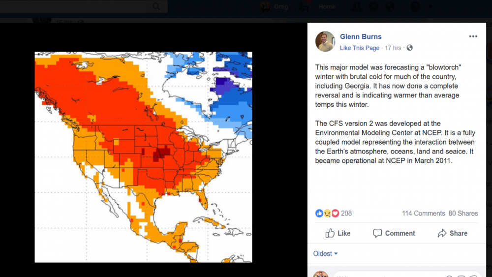
I'm not sure he was completely awake when he wrote that. Something is confused in there somewhere. The model has been forecasting a blowtorch winter all summer and fall. Either it is coming in line with the rest of the seasonals and that's what he's pointing out, or it has been showing a blowtorch and continues to show a blowtorch, in which case it is correct and everything else is sucking. I'm not entirely sure which option he's going with.
-
46 minutes ago, mackerel_sky said:
I’m tired of you being in camp negativity! Lighten up , Fran cis!
Where is packbacker?
-
I'm kind of in the QC camp in that it would be quite unusual to have a big winter storm so early in the season around here. That said, we are seeing some pretty favorable H5 looks being spit out of the models from time to time for late Nov/early Dec. We don't usually see this kind of thing so early in the season, so if we're going to do the unusual, this seems like the year it will happen. Either way, I'm just glad we're not in a warm pattern, seeing nothing but warm patterns, and wondering when it's going to end. Great to finally be able to be interested early in the season like this.
-
3
-


December 8-10, 2018 Winter Storm
in Southeastern States
Posted
Awesome. Thanks! Yep, sucks for us. But pretty typical.