

Cold Rain
-
Posts
23,935 -
Joined
-
Last visited
Content Type
Profiles
Blogs
Forums
American Weather
Media Demo
Store
Gallery
Posts posted by Cold Rain
-
-
6 minutes ago, Brick Tamland said:
I don't think the warming aloft will be as bad as you think. I think we will get a good thump of snow like Allan said, 4 to 6 inches, before getting some ice on top of it.
Ok good deal. Why do you think there won’t be much warming aloft?
-
 1
1
-
 2
2
-
-
I think we can all agree that the extended ranges of the NAM are suspect and that it’s snow map on TT is ridiculous. But there is going to be warming aloft here. And it will be warmer and more extensive than the globals are showing. For many in central NC, assuming we don’t have a convection moisture robbing situation (which is possible), there is going to be a lot of sleet and ZR, even back into the Triad and into parts of VA.
-
 1
1
-
1
-
 1
1
-
-
4 minutes ago, NCSNOW said:
So you think Greensboro only gets 1 to 2 inches. Interesting
They're right on the 2-4" line. I can make that work.
")
-
1
-
-
1 minute ago, Bevo said:
Imma need one of those sweet Cold Rain maps for clarification please...
I threw this down yesterday. Still looks good to me.
-
1
-
1
-
1
-
-
5 minutes ago, FallsLake said:
Hey CR, Look at how the 850 temps are trying to move back SW from Canada.
Click 4x back for "Prev. Run"
A few move movements back and we have a much better cold air feed.
Nice! Hopefully, that can work itself out before I throw in the towel!
-
2 minutes ago, Brick Tamland said:
Euro, UK, and CMC all look good. Not sure why people are saying they are showing less snow. Looks pretty consistent to me. It seems folks just don't want to believe the models because what they are showing is rare here.
What?? It's not rare at all for the models to show 6 inches of snow in Raleigh.
-
2
-
1
-
-
Just now, Cold Rain said:
The Euro did for some areas, but as you can see from the data over the course of the last 12 hours, generally, we're seeing things like weaker highs, slightly north or closer to the coast low pressures, slightly less of a cold air pus, and of course, the snow maps are starting to respond by showing less snow and/or migrating slightly north and west. Not really any better trends today for the south and east edges.
And by the way, this is completely typical for winter weather around here. North and west zones are favored and should do pretty well. I believe we've seen peak snowfall maps for this one. For south and eastern areas, we need to see big time suppression 5 days out. We go through this every winter.
-
7
-
-
1 minute ago, lilj4425 said:
Warmer? I thought the Euro got colder???
The Euro did for some areas, but as you can see from the data over the course of the last 12 hours, generally, we're seeing things like weaker highs, slightly north or closer to the coast low pressures, slightly less of a cold air pus, and of course, the snow maps are starting to respond by showing less snow and/or migrating slightly north and west. Not really any better trends today for the south and east edges.
-
1
-
-
Ha they're going to beef it up after models come in with a warmer solution. Still looks to be impactful west of the Triangle, though.
-
1
-
1
-
-
We can play around with long range NAM soundings, but the trend in this particular model is to delay and lessen the push of cold air and the strength of the high. There's no question aout that, and it's not good. That doesn't mean it's right. And it doesn't matter if it's exactly right. But if other models continue this trend in one way or another, then we have a problem, assuming you like lots of snow and an all frozen event.
-
3
-
-
1 minute ago, Brick Tamland said:
Okay, so where is the info that shows they could be wrong? What is the other info that RAH is basing their forecast on right now?
You will know they are wrong when ice is forming on the trees in your yard.
-
2
-
-
3 minutes ago, Brick Tamland said:
It been is just hard for me to ignore the consistency and agreement with the various models. I know what has happened in the past, but we also don't usually have this much consistency and agreement with the models. They would all have to be wrong or start to do a complete 180 now.
They would have to do a complete 180 for what to happen? All rain? Not sure anyone is calling for that. It’s hard for me to believe that you have been following the weather for as long as you have and have as much faith in 5 day snow maps as you do, regardless of their consistency.
-
3
-
-
Go to West Jefferson. It’s awesome.
-
1
-
-
1 minute ago, downeastnc said:
Colder and snowier much further east.....now if it will just go ENE from there instead of reforming off the NC coast we would be looking at a bigger event for central and eastern NC but that little jump north kills us.....
It might go ENE for one more frame. I guess we'll never know.

-
1
-
-
7 minutes ago, burgertime said:
But it's still a few days away?

I've lived here a long time!
We'll check back in on Tuesday and see how I did.
-
6
-
1
-
-
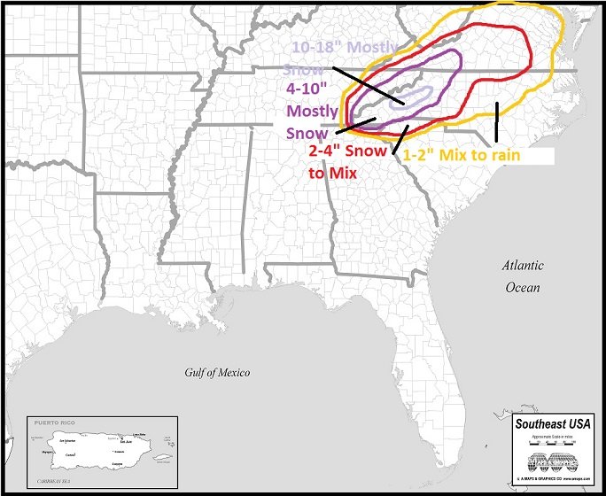
Here's my final call. Ignore areas outside of NC. Just drew a continuous area for symmetry, such that it is.

-
5
-
2
-
2
-
 2
2
-
-
It may prove me wrong this time, but I hate the Canadian model. It has been way north the whole time and is now correcting south. It's just not very good. I'm sure its solution is within the realm of possibility, but I still don't like it.
-
3
-
-
2 minutes ago, Buddy1987 said:
This is gold guys! ORH Wxman is amazing with this stuff when I lived up in the northeast still. Here’s the discussion:
This makes so much sense - see below, I guess all options are open.
Maybe at long leads we expect too much from the models, even in this day and age IMHO.
I brought this over from the New England forum, thanks @ORH_wxman .
<
The primary northern stream shortwave that phases on the euro doesn't come onshore near Juneau AK until 00z Friday.
The kicker behind it doesn't come onshore until 12z Saturday in the PAC NW.
The Arctic shortwave from the PV lobe that contributes to Quebec confluence is still over the central Arctic Ocean. It reaches Hudson Bay on Saturday...prob doesn't get decent sampling until it is near there since northern NW territories and the Canadian archipelago isn't exactly a poster child for a dense obs network...and satellite isn't going to be great there either with the extreme cold.
Bottom line is that we have a lot of northern stream and Arctic jet shortwaves that will matter to this system that are more prone to large changes than usual due to their position. So don't be surprised to see large changes on some model guidance between now and Saturday. It doesn't mean the changes will always be good for us, but obviously we will want to see changes for a hit here.
Thanks for posting this. I'm I wasn't out in left field with thinking that. I still think the Pac wave comes onshore a bit stronger than modeled. We'll see.
-
2
-
-
4 minutes ago, griteater said:
You got it Niner. Trend loop here on the EPS, including the most recent 06z run. So the 3 key players are the SE Canada trough (50/50 low), the southern stream wave, and the new shortwave dropping down from the northern stream (in S Dakota on the last image of the loop). Over time: 1) the 50/50 low has nudged southwest, 2) the model is seeing increased amplitude with the southern wave, and 3) the new northern stream shortwave is now getting more involved, and earlier. Note the trend of the height rises from Georgia up thru Kentucky. Height rises = warmer, and a more north solution (warmer aloft that is, not really at the surface where the damming high will do its dirty work). So, for a more south solution, we'd want to see the SE Canada trough to nudge more to the southwest, the southern stream wave to not be as amped, and to lessen the early involvement of the northern stream shortwave. The SW VA group would want to see it stay the same as it is now

I said this on the other board, but I've seen these waves coming in off the Pacific show up in the mid-range weak, many times, only to end up verifying stronger when they come ashore. I think it has to do with sampling. We'll know pretty soon, but that is going to make a difference, IMO. Also, I'm wondering if the waves dropping in from up north (strengthening the HP and interacting with the southern stream) are not well sampled yet either? All of that should be resolved soon, if they are even issues currently.
-
1
-
-
2 minutes ago, Queencitywx said:
Looking at the 6z NAM, we're clouded over here before Saturday even begins. The more we can limit sunlight that day, the better. With CAD already starting from the high, that could mean temperatures are cooler on Saturday and thus you get a lower wet bulb that evening or night.
Yep, that is definitely going to be key here. Every little bit will help.
-
3
-
-
2 minutes ago, snowinnc said:
I hope that you’re right but the trends are definitely going in the wrong direction for us.
They're not really. We just aren't getting in on the big snow totals. There is still a good shot at a winter storm here. It will likely be mixy, but that's to be expected, honestly. If we have a CAD situation like it looks like now, it will overperform.
-
5
-
-
1 minute ago, CaryWx said:
Well, sounds like Wake county is bowing out of the game.
Nah.
-
1 minute ago, PackGrad05 said:
I read these posts about Wake Co getting 10+ inches and central NC looking good this run... THEN the map is posted.
Do y'all know where Wake is? That EPS Clown map shows most of Wake in the 1-2" category.Euro control run. It basically has 10+ totals over Wake. More west. Regular Euro kills us with WAA.
-
1
-
-
1 minute ago, SnowDawg said:
Although max snow totals went down on GEFS, the snow coverage expanded quite a bit in all directions. A number of GEFS members have nudged south and west with snow totals. At 6z there were only around 6-7 members showing snow of at least an inch getting into most of N GA, and at 12z there are now 11-12. And the mean shows that with mean snowfall going up a bit across all of N GA and deeper into SC and nudging east towards the coast in NC. Yet another sign of models maybe starting to see stronger cold air transport.
Maybe picking up on damming better?
-
2
-
December 8-10, 2018 Winter Storm
in Southeastern States
Posted
I’ll bet he was!
Looks good right there.