
WxWatcher007
-
Posts
33,839 -
Joined
-
Last visited
Content Type
Profiles
Blogs
Forums
American Weather
Media Demo
Store
Gallery
Posts posted by WxWatcher007
-
-
WOW Humberto now forecast to become a cat 5
-
 1
1
-
-
2 minutes ago, LeesburgWx said:
Tucked.
Good to see the Euro AI take up the annual challenge of throwing tropical up the bay
-
5 minutes ago, nycwinter said:
jumping the gun a bit to early..
Yeah we have a long way to go…
-
2
-
-
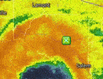
Even with this half scan, Humberto is an absolute beast.


-
26 minutes ago, GaWx said:
18Z Icon remained OTS. If this ends up not hitting the US, keep in mind that both the Icon and UKMET haven’t had even one run so far with anything even that close to a landfall. Those two models were the best with Ian by the way.
It would be an enormous coup, especially considering where the ensembles were.
-
30 minutes ago, ineedsnow said:
I'm surprised you didn't post the skynet version

-
 1
1
-
-
Somebody mentioned Joaquin the other page and man, this might be worse. I don’t think there’s anyone that even has a clue of what this will do.
-
1
-
2
-
-
It would be an all time win for the second tier models.
-
 1
1
-
-
This is truly remarkable uncertainty on the guidance given how close we could be to a landfall. The GFS follows what some ensemble camps have hinted at, but the outcome verbatim is just radically different in impacts and timing compared to recent op runs. This is a very tough system for emergency managers that need to prepare people to take action.
-
With Humberto rapidly intensifying today, another MH is on the board.
Peak Season Forecast (Aug 20-Oct 20)
Named Storms: 10 (3)
Hurricanes: 6 (2)
Major Hurricanes: 3 (2)Fernand, Gabrielle (MH), Humberto (MH)
-
1
-
-
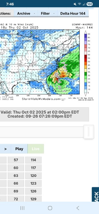
Taking a look at our coming PTC. Thanks to @Nibor for showing me how to post larger gif animations.
You can clearly see both the gradual organization and headwinds for the coming PTC 9. To the north, you can see arc clouds still radiating out of the area, indicating the presence of some dry air. You can also see some of the thunderstorm tops being sheared, although it does look like in recent frames that things may have slackened some.

It's easier to see the larger scale spin, and recon is on the way to examine how well defined a low level center there is. For a relatively short term forecast, there is still a lot to be figured out.
-
3
-
 1
1
-
-
13 minutes ago, olafminesaw said:
Pretty grim for a mean
It looks like the ensemble members on balance don’t have that coastal stall. The slower members stay OTS

-
1
-
-
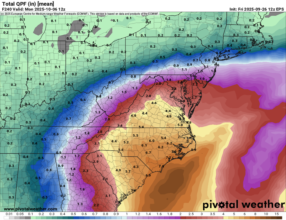
Don’t look at the specifics. I’m just highlighting the threat of widespread high end rainfall. That signal has been there consistently, even though the axis of heaviest rain has bounced around.


-
1
-
-
Note how the ridge above slams the door shut for an escape, even though Humberto is able to initially exert some influence. It leads to a prolific rain event...
-
1
-
 1
1
-
-
2 minutes ago, GaWx said:
Then per other sources it stalls just offshore for 24+ hours
-
1
-
1
-
-
Closer to the coast than 00z, but a departure from the clear landfall at 06z. Humberto is pulling away as the ridge rolls over the top so the escape route probably closes. Still a lot to figure out with not a lot of time.
-
1
-
-
3 minutes ago, dendrite said:
Another year of more spider posts than severe.

Keep this up and it might outdo winter storm posts.

-
1
-
1
-
 1
1
-
-
PTC likely later today
Tropical Weather Outlook
NWS National Hurricane Center Miami FL
200 PM EDT Fri Sep 26 2025

For the North Atlantic...Caribbean Sea and the Gulf of America:

Active Systems:
The National Hurricane Center is issuing advisories on Hurricane
Humberto, located over the subtropical central Atlantic, and has
issued the last advisory on Post-Tropical cyclone Gabrielle over
the northeastern Atlantic.

Southwestern Atlantic (AL94):
Satellite data and surface observations indicate that a low pressure
system appears to be forming near eastern Cuba and the southeastern
Bahamas.  This system is producing a large area of disorganized
showers and thunderstorms, and gusty winds. Gradual development of
this system is expected, and it will likely become a tropical
depression during the next day or so while it moves northwestward or
northward across the central and northwestern Bahamas.

Regardless of development, heavy rains and gusty winds are ongoing
in the Dominican Republic, Haiti, the Turks and Caicos Islands, the
southeastern Bahamas and eastern Cuba, and are likely to spread
across the remainder of the Bahamas over the weekend. Interests in
all of these areas should monitor the progress of the system.
Tropical storm watches or warnings could be required for portions of
the Bahamas and advisories on a potential tropical cyclone could be
issued as early as later today. While there remains considerable
uncertainty in the long-range track and intensity of the system,
there is a significant risk of wind, rainfall, and storm surge
impacts for a portion of the southeast U.S. coast early next week.
Interests in this area should also monitor the progress of the
system.
* Formation chance through 48 hours...high...90 percent.
* Formation chance through 7 days...high...90 percent.

$$
Forecaster Cangialosi/Reinhart/Hagen
-
1 hour ago, Nibor said:

How did you get a larger gif to post?
-
2 minutes ago, stormtracker said:
What are you talking aboot?
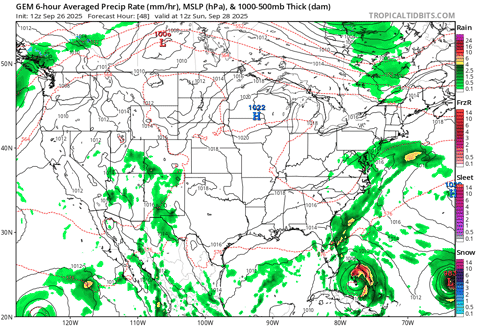
The Canadian keeps future Imelda offshore, but the massive ridge over the top blocks its escape and runs it up the coast.
Funky.
-
1
-
-
The Canadian, as usual, is funky.
-
Just now, NorthHillsWx said:
I’m very worried. This has high end flood potential written all over it even if it stalls just off the coast
Not to mention the onshore flow. A further south track with that flow over Charleston would be very bad. The Low Country is called that for a reason (I used to live in SC).
-
1
-
1
-
-
41 minutes ago, SJonesWX said:
ASATT
All spiders all the time
Exciting times in New England.
-
1
-
1
-
-
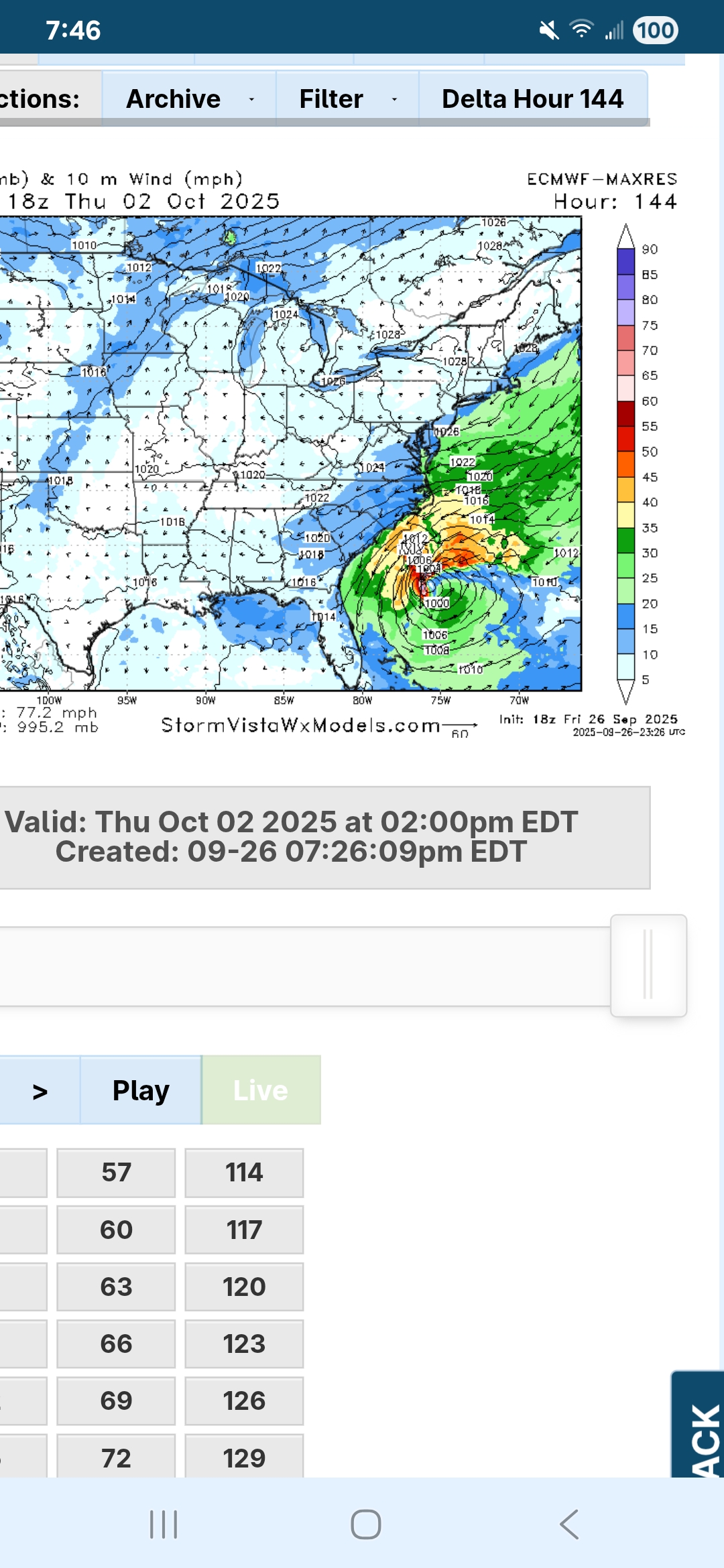
You can see pretty easily why the establishment of an inner core matters here. On the 06z GFS run, the core is weaker and less structurally sound, and as a result it’s easier for dry air to get entrained.

The result is a slowly intensifying storm (take note) on landfall.
12z has a symmetrical core, which not only makes it stronger but closes off the eye from dry air entrainment.

The result is a substantially stronger hurricane that is likely intensifying more robustly on landfall.
I can’t emphasize enough how important it’ll be to get a well defined LLC so that the models can figure this out. I think an east coast strike is highly likely at this point given the GFS/Euro and their ensembles overwhelmingly overlapping in the general upper level steering features.
-
10
-

Category Five Hurricane Humberto
in Tropical Headquarters
Posted