
WxWatcher007
-
Posts
33,839 -
Joined
-
Last visited
Content Type
Profiles
Blogs
Forums
American Weather
Media Demo
Store
Gallery
Posts posted by WxWatcher007
-
-
7 minutes ago, RU848789 said:
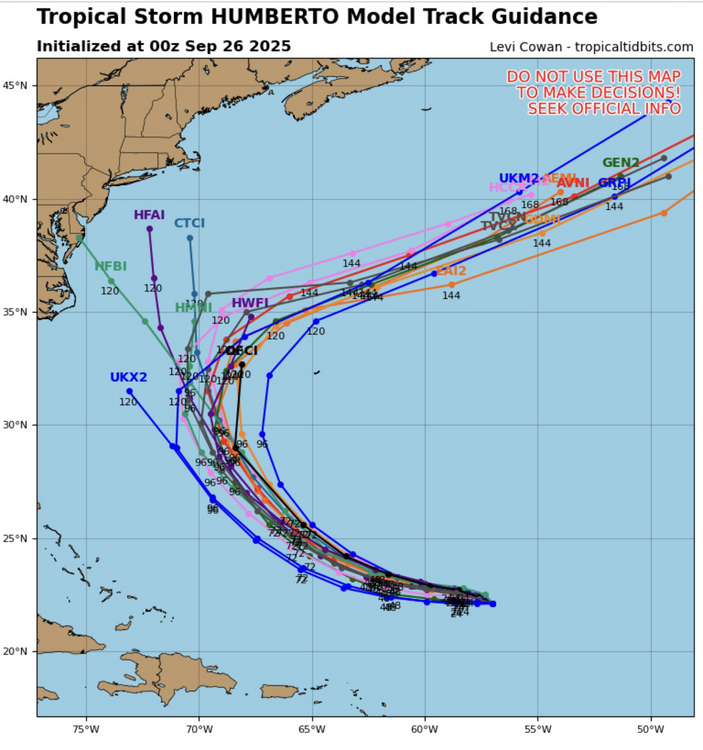
Greg Postell on TWC was just saying he thought there was enough evidence of a low level closed circulation to name this Imelda and isn't sure why it hasn't been named yet. Personally, given the wildly varying model runs to this point, I wonder if the NHC simply wants a bit more time to issue actual track/intensity forecasts. He also mentioned the conflict between anomalously warm waters ahead of Imelda vs. some very dry air aloft forecast to be in its path, making intensity forecasts very difficult - and we already know the impacts of the closed SE low and Humberto with possible Fujiwhara effects are making the track forecast very difficult. The one thing that seems almost a given is that at least parts of SC/NC/VA, especially near the coast, will get a lot of rain - how far inland that very heavy rain gets and whether we're talking 4-8" of rain (which most can handle) or 10-20" of rain (big flooding) is an open question.
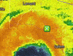
When looking at recon earlier I didn't think that we had anything closed, but perhaps that's a function of the possible LLC being so close to the coast that recon can't get there.

Looking at some of the surface observations, I guess you can close this off. I suppose the northerly wind on the south Cuban coast implies some sort of LLC. I just think it's marginal at best for now.

-
 1
1
-
-
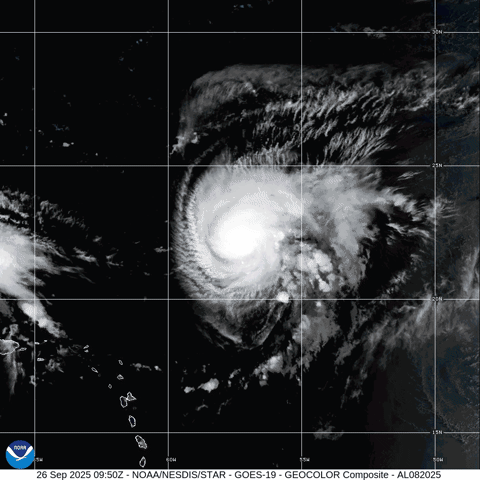
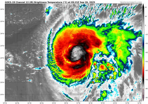
Hurricane Humberto Discussion Number   8
NWS National Hurricane Center Miami FL       AL082025
1100 AM AST Fri Sep 26 2025

Humberto continues to rapidly strengthen this morning. Infrared
satellite images show a ring of deep, cold inner core convection
wrapping around an eye that has recently emerged in conventional
satellite imagery. Objective satellite intensity estimates are
quickly climbing, and the initial intensity is raised to 80 kt for
this advisory, in best agreement with recent UW-CIMSS ADT and AiDT
estimates. A recent ASCAT-B pass over the hurricane was used to
update the 34- and 50-kt wind radii of Humberto.

The rapidly improving satellite structure, along with conducive
environmental and oceanic conditions, suggest that significant to
rapid intensification (RI) is likely to continue in the short term.
In fact, the latest DTOPS guidance shows a greater than 80 percent
chance of Humberto strengthening by 30 kt in the next 24 h. Thus,
rapid intensification is explicitly forecast here, and the NHC
intensity forecast has been raised during the first 48-72 h of the
forecast period. This forecast most closely follows the regional
hurricane models and the HFIP corrected consensus (HCCA), on the
higher end of the guidance envelope. By early next week, there are
indications that deep-layer shear will increase over Humberto, and
some weakening is shown beyond 72 h. Note that as Humberto gains
latitude, the wind field is forecast to expand while the hurricane
curves around Bermuda at days 4-5.

The hurricane is moving slowly northwestward at about 4 kt.
Humberto should move toward the west-northwest and northwest during
the next couple of days along the southern periphery of a
subtropical ridge over the western and central Atlantic. As this
ridge slides eastward, the hurricane is forecast to recurve around
this feature, turning northward and then accelerating northeastward
early next week. The models are in very good agreement on this
sharp recurvature over the western Atlantic, and only minor
adjustments were made to the latest NHC track forecast.


FORECAST POSITIONS AND MAX WINDS

INIT  26/1500Z 22.3N  57.7W   80 KT  90 MPH
 12H  27/0000Z 22.5N  58.3W   95 KT 110 MPH
 24H  27/1200Z 22.9N  59.6W  105 KT 120 MPH
 36H  28/0000Z 23.3N  61.3W  115 KT 130 MPH
 48H  28/1200Z 24.1N  63.3W  125 KT 145 MPH
 60H  29/0000Z 25.3N  65.2W  125 KT 145 MPH
 72H  29/1200Z 26.8N  66.9W  120 KT 140 MPH
 96H  30/1200Z 30.6N  68.8W  105 KT 120 MPH
120H  01/1200Z 34.5N  66.0W   90 KT 105 MPH

$$
Forecaster Reinhart
-
Looks like RI is well underway.
-
-
Just now, NVAwx said:
Can you link to the site of the data as it comes in?
https://www.tropicaltidbits.com/recon/
https://tropicalatlantic.com/recon/recon.cgi
There are other sites out there but I use these when recon is in the air. Expect consistent upper air and low level recon now.
-
2
-
-
Low level recon is in there for the first time this morning. Not seeing anything closed right now.
-
1
-
-
48 minutes ago, olafminesaw said:
Overnight ensembles showed more offshore solutions so it will be interesting if the 6z ensembles follow with the OP in showing mostly landfalls
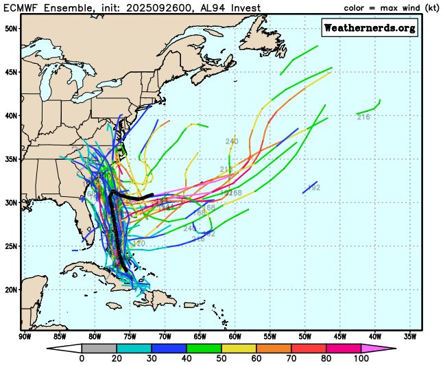
It looks like they follow the op with substantial spread still in landfall point.
-
Still feeling our way around solutions. The 06z Euro brings future Imelda onshore with a similar progression to its other prior runs—much faster than what the 00z had.

-
1 minute ago, GaWx said:
0Z GEFS: 14 of 30 members with SE US landfall with one of those 14 a hurricane
Very interesting stuff. Long way to go…
-
1
-
-
Yikes. That’s a bit of a change. Let’s see what the ensembles say.
-
20 minutes ago, Coach McGuirk said:
We have seen tropical storms go from nothing to a cat 4 in a day lately under the right conditions. I would not be surprised.
To overperform it has to have an inner core built pretty quickly this weekend. That’s worth watching for sure.
The intensification as it’s landfalling is an interesting signal since the environment is not ideal by then.
-
6 minutes ago, Weather Will said:
I updated the map. There are more members with heavier rain!
It’s a very interesting setup. Still very unclear what’ll happen.
-
 1
1
-
-
6 minutes ago, Weather Will said:
WB 0Z GEFS still lot of uncertainty on Imelda to be location and intensity. Very few members bring heavy rain to DMV.(Low to the east is Humberto.)

Watch the long range though. Remnants get picked up by a trough eventually.
-
 1
1
-
-
11 hours ago, WxWatcher007 said:
This is more long range speculation, but I do wonder if there’s a chance of remnants or something if the vorticity gets pushed back OTS after the original landfall. 00z euro and 12z gfs hint at it, but obviously that’s weenie range.
Showed up again at 18z and especially at 00z. Again, fantasy range and speculative but maybe worth watching as the ridge breaks down and a trough scoops up whatever remnants there are. Humberto is and was always gone.
-
1
-
-
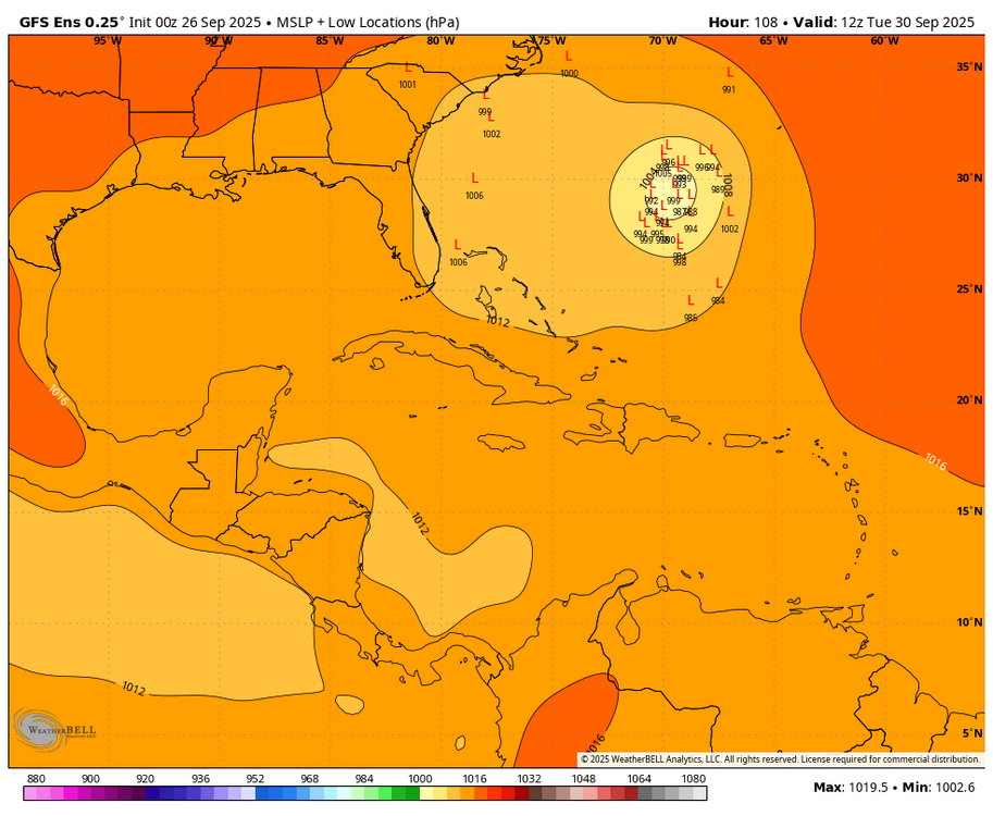
What a ridge on the GFS

-
25 minutes ago, Boston Bulldog said:
Shrimp mode on satellite, we likely have a hurricane soon
Looks like a nascent eye was trying to develop as of a few hours ago.

-
35 minutes ago, GaWx said:
The chances of this being a cat 4 H are very low as of now even with favorable MJO phase 2 being forecasted. The bigger risk as it appears now is the catastrophic flooding risk from a very slow moving storm, even if it were to landfall as just a TS. TS Chantal caused major flooding from record 24 hour rainfall in parts of NC.
Speculative at this point but I think anything from a TS to C3 are possible. I agree with the odds of a 4 being very low. I've said this elsewhere but we have to remember that major hurricane strikes along the east coast are actually pretty rare. Since 1990 there have only been three. Andrew '92, Fran '96, and Jeanne '04. Here, there's a window where this will likely intensify, but near the coast future Imelda may have to deal with the effects of southerly shear and dry air being imparted into the circulation. Along with cooler temperatures near the coast.


That said, the Euro has intensification near landfall, probably because there should be a strong outflow channel to the north.
Right now there is a robust mid-level circulation apparent on satellite. We really need to see how that translates as it reaches the high SST/OHC environment near the Bahamas tomorrow.
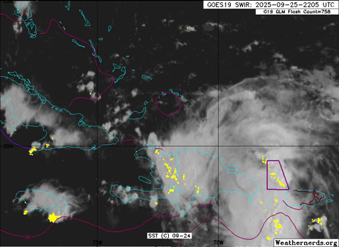
Given its current appearance and how Humberto was able to more quickly develop and intensify in its environment, I do think it's on the board that this has an impressive appearance tomorrow if shear relents some.


-
2
-
1
-
-
Tropical Storm Humberto Discussion Number   6
NWS National Hurricane Center Miami FL       AL082025
1100 PM AST Thu Sep 25 2025

Humberto continues to gain strength while moving slowly over the
central Atlantic.  The system is exhibiting a growing CDO feature
with cloud tops to near -70 deg C, along with some convective bands
over the eastern portion of the circulation, where most of the
lightning flashes are currently occurring.  The advisory intensity
is increased to 55 kt, in agreement with subjective Dvorak
classifications from both TAFB and SAB and a blend of objective
satellite estimates from UW-CIMSS.

The storm's forward speed is quite slow with a motion estimate of
only 320/3 kt.  Steering currents are not strong at this time since
the subtropical ridge to the north of Humberto is quite weak.
Global model forecasts show the ridge strengthening with time and in
a few days the cyclone should move somewhat faster toward the
northwest and turn northward in the vicinity of 70 W longitude. By
the end of the forecast period, after Humberto passes north of the
ridge, the system should begin accelerating northeastward.

Cirrus motions indicate that the vertical wind shear over Humberto
has lessened, and the SHIPS model output does not show the shear
increasing much through 72 hours.  Sea surface temperatures are
expected to be very warm along the projected path of the cyclone,
and the system should remain embedded in a moist air mass.  The
official forecast continues to call for significant strengthening
during the next few days.  This is consistent with the latest
corrected consensus, HCCA, forecast which also shows Humberto
intensifying into a major hurricane this weekend.


FORECAST POSITIONS AND MAX WINDS

INIT  26/0300Z 22.2N  57.1W   55 KT  65 MPH
 12H  26/1200Z 22.4N  57.6W   65 KT  75 MPH
 24H  27/0000Z 22.7N  58.5W   75 KT  85 MPH
 36H  27/1200Z 22.9N  59.9W   90 KT 105 MPH
 48H  28/0000Z 23.4N  61.8W  105 KT 120 MPH
 60H  28/1200Z 24.3N  63.8W  110 KT 125 MPH
 72H  29/0000Z 25.4N  65.7W  110 KT 125 MPH
 96H  30/0000Z 29.0N  69.0W  100 KT 115 MPH
120H  01/0000Z 32.6N  69.7W   90 KT 105 MPH

$$
Forecaster Pasch
-
1
-
-
Gale-force winds extend outward up to 160 miles (260 km) from the
center.  A sustained wind of 71 mph (114 km/h) with a gust to 86
mph (138 km/h) was recently reported by a station on Terceira Island
in the central Azores at an elevation of 884 feet (269 m).  Closer
to sea level, a wind gust to 58 mph (93 km/h) was measured at Ponta
Furada on Faial Islan
-
1
-
1
-
-
7 minutes ago, bncho said:
february 19-20 debacle lol
That was all time horrific. Makes me sick even thinking about it.
-
37 minutes ago, MJO812 said:
Pig ridge stretching from International Falls to Iceland?
-
1
-
-
I think it’s still worth plenty of caution to look too much into intensity guidance given the lack of a center. We do know there will be a favorable environment window early, followed by likely hostile conditions. But how much that impacts Imelda will depend on how structurally sound any inner core is.
-
Just now, JenkinsJinkies said:
I’ve seen this song and dance before. Once a ridge shows up to spoil our precip it’s here to stay. It goes hand in hand with walkbacks begetting further walkbacks.
Maybe. This is a pretty anomalous ridge for this time of year I think.
-
I'm still a bit skeptical of such a strong ridge, but if that is the case we will need to watch if future Imelda is able to get back offshore. If so, the guidance seems to believe some sort of regeneration is possible, and with that ridge rolling east that would probably lead to something running up the coast either inland or just offshore. Fantasy range but something to monitor.
-
1
-


2025 Tropical Tracking Thread
in Mid Atlantic
Posted
Meanwhile, Humberto is likely a major already. It just exploded in intensity.