
WxWatcher007
-
Posts
33,839 -
Joined
-
Last visited
Content Type
Profiles
Blogs
Forums
American Weather
Media Demo
Store
Gallery
Posts posted by WxWatcher007
-
-
13 minutes ago, Great Snow 1717 said:
There are some good values on condos available in Florida..
Why move to Florida when we can do sunny, dry, and AN without the humidity DJF?
-
 1
1
-
-
11 minutes ago, GaWx said:
The Gulf looks somewhat active (more active than most of the season so far) overall on the 12Z models so far. However, the UKMET, which goes out only 168, did drop the Gulf TC per its textual output that it had on its prior 2 runs.
Looking at the recent guidance, if I were going to highlight some areas of interest it would be the Gulf/SE Coast in the next week, the western Caribbean with a weak CAG signal in the 7-10 day period, and a tropical wave in the MDR in that same period. It looks pretty active--or at least there will be chances for TC genesis. Might do a post later about it.
I track my peak season forecast numbers in the legacy Mid-Atlantic thread, but I'll post here too. Imelda likely gets me to 3 H or 50% of my forecast with three full weeks left (including today). It has an outside shot at MH, which may all but guarantee that I am too low on MH as I expect at least high end activity in October.
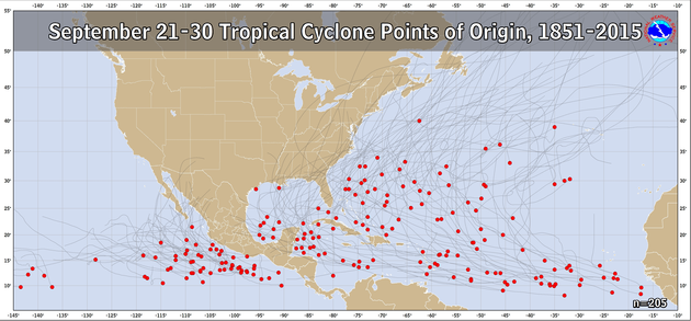
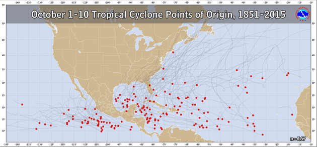
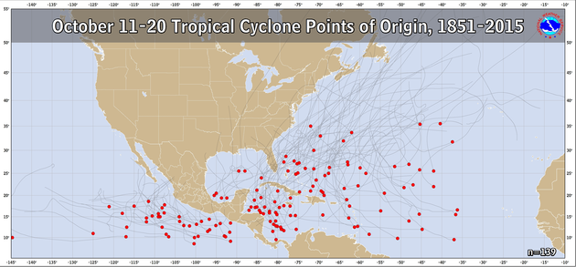
Unfortunately for coastal residents, I still think a MH strike is likely, and that the east coast isn't out of the woods on threats. I'm not sure what to think about Imelda's threat to the coast--if not for Humberto going nuclear, I think this would've been the EC hurricane strike I predicted. For the east coast that definitely gets less likely in October though as the images I posted above show, that's really after the 10th.
Peak Season Forecast (Aug 20-Oct 20)
Named Storms: 10 (4)
Hurricanes: 6 (2)
Major Hurricanes: 3 (2)Fernand, Gabrielle (MH), Humberto (MH), Imelda
-
 3
3
-
 1
1
-
-
Should've posted this yesterday but it actually makes more sense today as Imelda is on an intensification trend. Imelda adds to the list and should become a hurricane. Outside shot at a major. The peak season forecast is still up in the air, but with activity still expected on the models and in the areas I highlighted, I like where I sit.
Peak Season Forecast (Aug 20-Oct 20)
Named Storms: 10 (4)
Hurricanes: 6 (2)
Major Hurricanes: 3 (2)Fernand, Gabrielle (MH), Humberto (MH), Imelda
-
18 minutes ago, NorthHillsWx said:
Honestly this storm had organized at a quick pace overnight with pressure falls and a the center under the CDO. Think pace of intensification quickens through the day
The ragged eyewall does look like it collapsed per recon, but that's not really a surprise given IR last night. I do agree that the presentation has really improved and the pressure falls have been impressive.
-
We uninstalled weeks ago and haven't looked back.
-
1
-
-
Just now, MegaMike said:
Absolutely not. Maybe it performed well for this one event, but that doesn't mean it's better than traditional NWP. You really need to conduct a thorough evaluation at the surface and aloft (for forcing variables) to make such conclusions.
As an example, it's possible something can be right for the wrong reason. You wouldn't know unless you evaluated it... So, if AI did well with forcing, wrt NWP, over a duration of 1 year, then you can entertain the idea. This is just imo, but we're years, if not decades, away from this. We likely need to significantly improve data assimilation for this to occur.
Agree with this. I will say that some of the AI models earned a little more respect with me this season, but to your point--it's going to take time to truly get a sense of how well it analyzes critical forecasting factors over the long term. Every forecast is different and every TC is a distinct entity.
And at any rate...models are merely tools. So us laypeople should beware relying on any one as gospel in any situation. (not saying that anyone here is necessarily doing that)
-
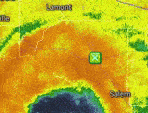
Also, this is an extraordinary satellite image. About as close as you can get. Both in coastal impacts and two TCs interacting with one another.

-
2
-
2
-
-
The wind field is still not particularly organized or strong, but the winds are gradually coming up as the satellite presentation continues to improve.

The center is now under a developing CDO, with persistent deep convection we should see the pace of organization pick up over the course of the day. The pressure has continued to fall, with the latest center dropsonde showing a possible pressure below 990mb now.

Product: Air Force Temp Drop (Dropsonde) Message (UZNT13 KNHC)
Transmitted: 29th day of the month at 13:23Z
Agency: United States Air Force
Aircraft: Lockheed WC-130J Hercules with reg. number AF97-5304
Storm Name: Imelda
Storm Number: 09 (flight in the North Atlantic basin)
Mission Number: 22
Observation Number: 10
Part A...
Date: Near the closest hour of 13Z on the 29th day of the month
Highest Mandatory Level For Which Wind Was Reported: 925mb
Coordinates: 26.6N 77.2W
Location: 108 statute miles (173 km) to the N (5°) from Nassau, Bahamas.
Marsden Square: 080 ( About )
Surface and Standard Isobaric Surfaces Level Geo. Height Air Temp. Dew Point Wind Direction Wind Speed 1000mb -93m (-305 ft) This level does not exist in this area of the storm above the surface level. 990mb (29.24 inHg) Surface (Sea Level) 26.0°C (78.8°F) 25.5°C (78°F) 135° (from the SE) 20 knots (23 mph) 925mb 596m (1,955 ft) 23.8°C (74.8°F) 23.2°C (74°F) 145° (from the SE) 15 knots (17 mph) 850mb 1,337m (4,386 ft) 21.6°C (70.9°F) 20.3°C (69°F) No Wind Report Available For This Level
Information About Radiosonde:
- Launch Time: 13:13Z
- About Sonde: A descending radiosonde tracked automatically by satellite navigation with no solar or infrared correction.
Remarks Section...
Dropsonde Location: Dropped in center.-
4
-
1
-
-
I think the risk is still there, especially as climo shifts to the Gulf/Western Caribbean.
-
3
-
-
1 hour ago, 40/70 Benchmark said:
Yea, obviously the point isn't to expect a record winter, but rather we shouldn't be resigned to another dud because the year has been dry thus far.
I hope so. I haven’t done too much thinking about winter yet but it’s less that it’s been dry thus far in my mind and more the background state of warm seasons and worse, that it seems our results are untethered from patterns that normally would be good to great for us. That concerns me. Like @CoastalWx, I’ve totally lost faith after the last decade.
-
1
-
-
6 hours ago, Snowedin said:
That Christmas was something else. I remember looking for the switch for the a/c that morning and then realizing we’d turned it off nearly 2 months prior! That day was the definition of torch.
Truly horrific.
-
1
-
-
5 minutes ago, GaWx said:
The 0Z UKMET (a model that tends to be a bit more stingy with TCG than the GFS) is the 2nd run in a row that develops a TC from the current C Gulf weak surface low after it moves S into the Bay of Campeche. This run actually has minimal TS winds early on. Whereas the prior run then moved it into a threatening position in the W-C Gulf, this run only moves it slowly back N to the end of the run:
NEW TROPICAL CYCLONE FORECAST TO DEVELOP AFTER 108 HOURS
FORECAST POSITION AT T+108 : 19.9N 94.7W
LEAD CENTRAL MAXIMUM WIND
VERIFYING TIME TIME POSITION PRESSURE (MB) SPEED (KNOTS)
-------------- ---- -------- ------------- -------------
1200UTC 03.10.2025 108 19.9N 94.7W 1009 36
0000UTC 04.10.2025 120 19.7N 93.9W 1008 31
1200UTC 04.10.2025 132 19.5N 93.9W 1006 31
0000UTC 05.10.2025 144 20.1N 94.2W 1005 29
1200UTC 05.10.2025 156 20.2N 94.0W 1005 26
0000UTC 06.10.2025 168 20.7N 94.5W 1004 27The GFS and Euro look like they’ve been trying to catch up with showing more vorticity and maybe a weak low developing, but time and shear may be inhibitors. There’s very clearly spin, but no convection whatsoever. It’s at least lemon worthy imo.
-
1
-
-
Recon has been in Imelda and although it has not intensified much (there are stronger FL winds showing up now), it is confirming that the satellite appearance of more organization near the center is legit.

Note that curved band of deep convection near the center, and how it is trying to wrap upshear. We'll see if the shear currently present keeps this organizational trend in check.
Product: Air Force Vortex Message (URNT12 KNHC)
Transmitted: 29th day of the month at 2:20Z
Agency: United States Air Force
Aircraft: Lockheed WC-130J Hercules with reg. number AF98-5307
Storm Name: Imelda
Storm Number & Year: 09 in 2025 (flight in the North Atlantic basin)
Mission Number: 20
Observation Number: 09 ( See all messages of this type for this mission. )
A. Time of Center Fix: 29th day of the month at 1:53:20Z
B. Center Fix Coordinates: 24.74N 77.09W
B. Center Fix Location: 27 statute miles (44 km) to the SE (142°) from Nassau, Bahamas.
C. Minimum Height at Standard Level: 1,420m (4,659ft) at 850mb
D. Minimum Sea Level Pressure: 998mb (29.47 inHg)
E. Dropsonde Surface Wind at Center: From 160° at 3kts (From the SSE at 3mph)
F. Eye Character: Open in the southeast
G. Eye Shape & Diameter: Circular with a diameter of 25 nautical miles (29 statute miles)
H. Estimated (by SFMR or visually) Maximum Surface Wind Inbound: 31kts (35.7mph)
I. Location & Time of the Estimated Maximum Surface Wind Inbound: 80 nautical miles (92 statute miles) to the NE (46°) of center fix at 1:28:30Z
J. Maximum Flight Level Wind Inbound: From 104° at 46kts (From the ESE at 52.9mph)
K. Location & Time of the Maximum Flight Level Wind Inbound: 75 nautical miles (86 statute miles) to the NE (45°) of center fix at 1:30:00Z
L. Estimated (by SFMR or visually) Maximum Surface Wind Outbound: 28kts (32.2mph)
M. Location & Time of the Estimated Maximum Surface Wind Outbound: 16 nautical miles (18 statute miles) to the SW (228°) of center fix at 1:58:30Z
N. Maximum Flight Level Wind Outbound: From 344° at 38kts (From the NNW at 43.7mph)
O. Location & Time of the Maximum Flight Level Wind Outbound: 35 nautical miles (40 statute miles) to the SW (228°) of center fix at 2:04:00Z
P. Maximum Flight Level Temp & Pressure Altitude Outside Eye: 16°C (61°F) at a pressure alt. of 1,526m (5,007ft)
Q. Maximum Flight Level Temp & Pressure Altitude Inside Eye: 20°C (68°F) at a pressure alt. of 1,525m (5,003ft)
R. Dewpoint Temp (collected at same location as temp inside eye): 19°C (66°F)
R. Sea Surface Temp (collected at same location as temp inside eye): Not Available
S. Fix Determined By: Penetration, Radar, Wind, Pressure and Temperature
S. Fix Levels (surface & flight level centers within 5nm of each other): Surface and 850mb
T. Navigational Fix Accuracy: 0.02 nautical miles
T. Meteorological Accuracy: 4 nautical miles
Remarks Section - Remarks That Were Decoded...
Maximum Flight Level Wind: 46kts (~ 52.9mph) which was observed 75 nautical miles (86 statute miles) to the NE (45°) from the flight level center at 1:30:00Z
Remarks Section - Additional Remarks...
RAGGED EYEWALL 50% COVERAGE-
1
-
-
7 minutes ago, powderfreak said:
My feeling is that it isn't going to snow anyway, and it's getting darker earlier, so I enjoy the nice weather being outside as much as possible.
My energy bill appreciates it with no AC or Heat.
By early to mid November, I'm game for sustained normal to below weather for snowmaking. Have a full month+ though before it starts to matter. 48F and rain doesn't do much for me.
I love fall and being in the Goldilocks zone for wx this time of year, so I’m with you on decent warmth—I just don’t like the upper level look. I want to see step downs. We keep saying these warm falls are fine and then I’m looking at +2 DJF and 30% of snow climo on March 15.
I guess you could say I’m spooked

-
2 minutes ago, powderfreak said:
That sounds about right as we head into the lower sun angle time of year.
Mother Nature loves prolonging the sweet spot of temperatures in the 60-80F range as long as possible.
I really don’t like this but if there’s a saving grace hopefully we snap back to troughing as we get closer to November.
-
1
-
-
18 minutes ago, hawkeye_wx said:
Recon is finally into Humberto. The pressure is 929 mb. There are a couple wind maxima and the max wind on the first pass was only 120 kts flight level.
Shame they couldn't be there during the peak, but it's good to have data.
-
11 minutes ago, NorthHillsWx said:
Put up or shut up time for the gulf
Yeah Oct 7-20 is critical to my peak season forecast. I'm still thinking things heat up in the western Caribbean and Gulf during that period, and then we are winding down the season by the end of October.
-
A truly terrible game.
-
High here of 85.4
-
1
-
-
26 minutes ago, Weather Will said:
Didn't the EURO AI have several runs run up the coast before caving to the ICON/Canadian?
Yes
-
1
-
-
Not much to say right now as Imelda continues to gradually (and slowly) organize.

As the NHC notes, with the change in track forecast and further south position, this may end up in a more favorable position relative to the trough and SST/OHC, which could open the door for more intensification once this develops an inner core and pulls away from the coast. I think Imelda has an outside chance at becoming a major in the coming days.
SHIPS continues to show meaningful probabilities for RI.

-
1
-
-
23 minutes ago, Terpeast said:
The AI models still have a long way to go, but they have been particularly good at predicting tropical cyclone tracks.
They have certainly earned my respect this season.
-
High of 85.1 here at WXW1. Average high is 71 lol. This is legitimate summer like wx.
-
1
-
-
15 minutes ago, kdxken said:
Nicest August ever, September ever, let's make it a three-peat for October.
11 minutes ago, SnoSki14 said:Probably lock that in all winter too.
-
1
-
 2
2
-
Spooky Season (October Disco Thread)
in New England
Posted
Of course not lol