
WxWatcher007
-
Posts
33,839 -
Joined
-
Last visited
Content Type
Profiles
Blogs
Forums
American Weather
Media Demo
Store
Gallery
Posts posted by WxWatcher007
-
-
6 minutes ago, GaWx said:
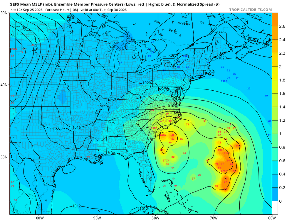
The 12Z EPS, while still scary for the SE US with ~60% hitting and ~50%+ of those hitting being strong TS+, isn’t quite as ominous as the 0Z, which had ~75% hitting the SE. About 40% of members are strongly affected by Fujiwhara with Humberto.
Hammering home the point that—for anyone lurking—even with the trend from the Euro and GFS, there is still a **high** amount of uncertainty on eventual track and intensity. Nothing is locked in yet.
-
 6
6
-
-
First time all season this thread has been hot lol
-
2
-
 4
4
-
 1
1
-
 1
1
-
-
4 minutes ago, olafminesaw said:
I'd say this is going to get the potential tropical cyclone designation/forecast cone this evening, but I wouldn't blame the NHC if the held off as long as possible until they can get some better data
Not sure if it’d happen today as the 2pm TWO didn’t mention it, but maybe at 11pm and almost certainly tomorrow given it’s proximity to the islands.
-
This could really be a prolific rainmaker if it gets trapped under the ridge.
-
2
-
 1
1
-
-
5 hours ago, CoastalWx said:
Effing gyre ftl.
Only in New England.
-
4 minutes ago, wncsnow said:
Euro shows serious flooding in NC and possibly VA/SC as the confluence in the NE stalls the storm out and helps draw moisture from Humberto.
.thumb.png.af8d5a8ef7967ae0a4aa1828fae8f168.png)
I think regardless of track there’s going to be a flood risk maybe up to the Mid-Atlantic given the upper level setup. Hopefully not to this extent though.
-
4 minutes ago, Nova737 said:
I know I should be thankful that there is no longer a direct threat to us from whatever 94L becomes, but boy was I hoping for it. :/
This is more long range speculation, but I do wonder if there’s a chance of remnants or something if the vorticity gets pushed back OTS after the original landfall. 00z euro and 12z gfs hint at it, but obviously that’s weenie range.
-
1 minute ago, olafminesaw said:
I was just going to post—no surprise being just over 100 hours out but the GEFS essentially follow the op but with more of a NC threat. Everything is still on the table but I’m not convinced this hooks well into SC. I think that’s an unusual track climatologically speaking.
-
3
-
-
Some of the second tier models still have a binary interaction that pulls future Imelda away, but with the Euro/GFS/AI models aligning at least right now that increases the risk to the coast substantially imo. Still, any one solution is far from guaranteed.
-
1
-
-
Yup building ridge to the north just traps it. Of course, that’s the furthest out and least confident part of the forecast.
-
1
-
-
46 minutes ago, weatherwiz said:
Once we start to get something a bit more organized we should get a better idea. The "center" has been jumping like crazy over the last day, particularly since last evening. Once concern I have though is potential for RI if this
1) gets its act together quickly
and
2) If it tracks within the zone of higher OHC
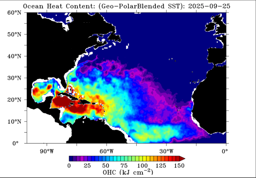
Doesn't mean anything for us but I would be watching extremely closely anywhere from the northeast Florida coast up to coastal NC.
There will be a window for significant intensification but idk how long it’ll be open for. You have near record warmth near the Bahamas and critically this should establish a nice outflow channel with a ULAC over the region and cutoff to the west. It’ll be in near ideal conditions.
However, nearing the coast southerly shear could impart dry air and the immediate coastline has cooler SSTs.
Folks should remember that major EC strikes are rare. Since 1990 it’s only been Andrew ‘92, Fran ‘96, and Jeanne ‘04.
-
1
-
 1
1
-
-
-
30 minutes ago, MJO812 said:
.thumb.png.1036e919bef6f8aa1641b2a49409bd8e.png)
Not surprising but quite a shift.
-
Just now, WxWatcher007 said:
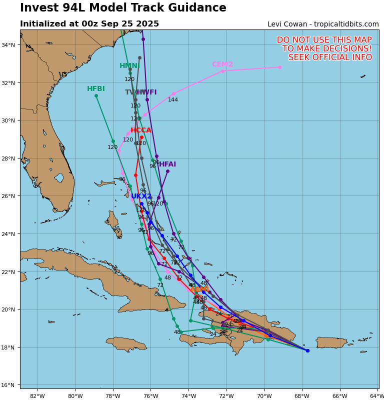
I now believe that Invest 94L is a bona fide threat to the U.S. East Coast.
Still, there is enormous uncertainty regarding the intensity and track of what is likely to become Imelda in the coming days.
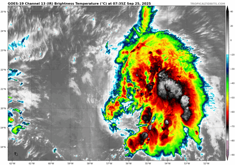
First, let's take a look at Humberto, which will play a critical role in the track of 94L. Although still sheared with the center likely west of the deeper convection, this tropical storm is on a clear organizing trend.

The spacing between Humberto and 94L has been a point of discussion for days now. How close these two get will determine whether there will be a binary interaction.
The GFS, which after sniffing out the potential for TC development in the SW Atlantic then kind of got lost in trying to consolidate the two waves, has clearly trended toward the Euro--to the extent you can with this much uncertainty in the setup. These are the last 5 GFS runs.
Note how the trend has been two-fold. First, there is the obvious change that makes 94L stronger. That decreases the likelihood that it is absorbed by Humberto and given an escape route OTS. The second change is the spacing. It's subtle, but can be seen easily. A stronger and more organized 94L would likely have the outflow necessary to keep Humberto at bay.
On the Euro, you see a similar trend with regard to spacing. Note how the escape routes of 1) Humberto and 2) NW flow in New England and SE Canada are blocked. These are the last 3 runs--not including this morning's 06z op run which continues the trend.
The spacing difference is more than enough here to limit the impact of Humberto.
Are we guaranteed a SE coast hit? Not at all. There are a lot of nuances remaining, including how quickly Humberto intensifies and its forward speed, the amplitude of the ridge and how it develops, and the amplitude of the cutoff over the CONUS.
It is very clear, however, that 94L is poised to develop, and it poses a risk to at least the SE coast with regard to a direct hit, with possible impacts further north depending on track.
Reposting here.
-
3
-
-
I now believe that Invest 94L is a bona fide threat to the U.S. East Coast.
Still, there is enormous uncertainty regarding the intensity and track of what is likely to become Imelda in the coming days.
First, let's take a look at Humberto, which will play a critical role in the track of 94L. Although still sheared with the center likely west of the deeper convection, this tropical storm is on a clear organizing trend.
The spacing between Humberto and 94L has been a point of discussion for days now. How close these two get will determine whether there will be a binary interaction.
The GFS, which after sniffing out the potential for TC development in the SW Atlantic then kind of got lost in trying to consolidate the two waves, has clearly trended toward the Euro--to the extent you can with this much uncertainty in the setup. These are the last 5 GFS runs.
Note how the trend has been two-fold. First, there is the obvious change that makes 94L stronger. That decreases the likelihood that it is absorbed by Humberto and given an escape route OTS. The second change is the spacing. It's subtle, but can be seen easily. A stronger and more organized 94L would likely have the outflow necessary to keep Humberto at bay.
On the Euro, you see a similar trend with regard to spacing. Note how the escape routes of 1) Humberto and 2) NW flow in New England and SE Canada are blocked. These are the last 3 runs--not including this morning's 06z op run which continues the trend.
The spacing difference is more than enough here to limit the impact of Humberto.
Are we guaranteed a SE coast hit? Not at all. There are a lot of nuances remaining, including how quickly Humberto intensifies and its forward speed, the amplitude of the ridge and how it develops, and the amplitude of the cutoff over the CONUS.
It is very clear, however, that 94L is poised to develop, and it poses a risk to at least the SE coast with regard to a direct hit, with possible impacts further north depending on track.
-
10
-
3
-
 1
1
-
-
I wouldn't look at the verbatim output seriously yet. Look at the upper level pattern.

-
1
-
1
-
-
For New England, this one looks gone for now for a direct strike. The only "hope" would be what the 00z Euro showed and some sort of regeneration in the long range as the ridge rolls east. Or something like the EPS this hits the Carolina coast first but continues to be dragged northward with a more robust ECONUS cutoff. Even under that scenario, idk if we see a real EC runner and obviously the further inland the weaker it becomes. Though that would probably create a big rain setup.

This is absolutely a legit threat for the southeast though. Fujiwhara is rare in the Atlantic for a reason, and even though Humberto is likely to become a major you look at 94L this morning and that's not a system that's just going to get absorbed. It may very well get going quickly once it can develop a LLC on the other side of Hispaniola.
-
No surprise but officially expected to become our next major now.
Tropical Storm Humberto Discussion Number   2
NWS National Hurricane Center Miami FL       AL082025
1100 PM AST Wed Sep 24 2025

The cloud pattern of Humberto has changed little in organization
over the past several hours.  Some rudimentary convective banding
features are evident but the cold cloud tops are rather fragmented
at this time.  Upper-level outflow is  being restricted over the
western portion of the circulation, at least partially due to the
outflow from disturbance 94L located near Puerto Rico.  The current
intensity estimate is set at 40 kt in agreement with a recently
received scatterometer pass.

The storm center is not yet very well-defined so the initial motion
is a rather uncertain 300/10 kt.  Over the next few days, Humberto
should be steered generally west-northwestward to northwestward on
the southwestern side of a subtropical mid-level high pressure area.
The steering scenario for the tropical cyclone will likely become
more complicated in 2-3 days due to the interaction with the
developing system 94L to the west.  The official forecast track is
quite similar to the previous one, and roughly in the middle of the
guidance.  However, due to the likely complications in the evolution
of the steering flow, there is lower than normal confidence in this
track forecast.

Global models suggest that there will be some relaxation in westerly
vertical wind shear over Humberto in the coming days. This, along
with very warm ocean waters and a moist mid-level air mass, should
lead to strengthening.  The system will probably become a hurricane
in a couple of days, and then strengthen into a major hurricane.
The official intensity forecast is in reasonable agreement with the
simple and corrected model consensus, including the latest FSU
Superensemble forecast.


FORECAST POSITIONS AND MAX WINDS

INIT  25/0300Z 20.7N  55.8W   40 KT  45 MPH
 12H  25/1200Z 21.4N  56.7W   45 KT  50 MPH
 24H  26/0000Z 21.9N  57.3W   50 KT  60 MPH
 36H  26/1200Z 22.4N  57.9W   55 KT  65 MPH
 48H  27/0000Z 22.9N  58.8W   60 KT  70 MPH
 60H  27/1200Z 23.4N  60.1W   70 KT  80 MPH
 72H  28/0000Z 24.0N  62.0W   85 KT 100 MPH
 96H  29/0000Z 26.3N  66.0W  100 KT 115 MPH
120H  30/0000Z 30.1N  68.9W  100 KT 115 MPH

$$
Forecaster Pasch/Blake
-
1
-
-
1 minute ago, MJO812 said:

What was 12z and 18z?
-
14 minutes ago, MJO812 said:
Track it with us

-
1
-
9
-
 1
1
-
-
7 minutes ago, ineedsnow said:
snow season will be here soon enough.. the weather has been so boring so I'm trying to find anything remotely exciting..
More of the same in the 2020s? No thank you.

-
1
-
-
41 minutes ago, ineedsnow said:
18z GFS figured out there will be two storms
38 minutes ago, ineedsnow said:GEFS also more robust with two storms
Still an OTS look verbatim.
-
1
-
-
5 hours ago, WxUSAF said:
Sorta similar setup too with the coastal. Op Euro goes nuts with it. 2” swath through metro corridor. Would be nice after this storm is a semi-bust.
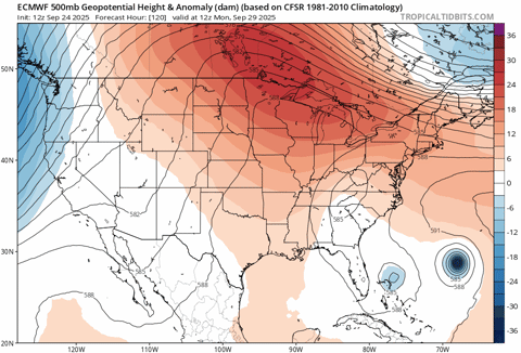
Euro is showing a deep tropical feed through the region with the cutoff trough in the southeast and future Imelda moving north out of the Bahamas.
-
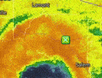
Not surprising that models are flip flopping all over the place. GFS after losing 94L for a while now develops it in the 18z run. Given how robust 94L has looked, I've always sold the idea that it wouldn't develop, but let's see how it handles interacting with the mountains of Hispaniola.
Peak Season Forecast (Aug 20-Oct 20)
Named Storms: 10 (3)
Hurricanes: 6 (1)
Major Hurricanes: 3 (1)Fernand, Gabrielle (MH), Humberto
.png.f02472c00f83f90eea2ea77fd242d59c.png)

.png.8bf6558bc5eafa695a443fdbdb2e41d0.png)
2025 Tropical Tracking Thread
in Mid Atlantic
Posted
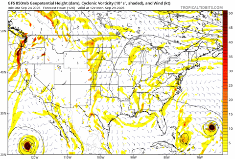
That is an impressive ridge on the GFS that stops future Imelda’s northward progress right in its tracks.