7:10 BOX DISCUSSION:
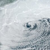
Details... Friday night through Saturday night... ***A Strong Winter Storm will impact southern New England Saturday*** After a jog east with the 12Z/18Z guidance yesterday, this evening`s 00Z models have ticked back west; a windshield wiper effect we often see in computer models leading up to these events and why you don`t want to hang your hat on one deterministic model run. This remains a decidedly chaotic forecast with decent run-to-run consistency in some models/ensembles, but large model-to-model discrepancies. One of the biggest struggles is how to resolve the upper air pattern with northern and southern stream energy that may phase leading to a more volatile system. The biggest outlier is the GFS which continues to depict a track well southeast of the 40/70 benchmark, while the NAM/Canadian/ECMWF are further northwest (if much slower, in the NAM`s case). For now the forecast continues to go with a blend of guidance, more or less in line with the ECMWF run which is a compromise between the GFS east and UKMET west. Ultimately the evolution of the parent 500 mb trough that digs into the Ohio and Tennessee valleys Friday night and Saturday will help to determine the track of the surface low. Confidence is high that this low will strengthen rapidly as it moves up the east coast, likely undergoing bombogenesis, meaning its central pressure drops at least 24 mb in 24 hours. This will bring the threat for significant snow, potentially damaging winds, and coastal flooding. Thinking this morning is that the significant snowfall threat will be centered over southeast Massachusetts, diminishing to the northwest. Given QPF of nearly 1.5 inches toward eastern MA and a cold column leading to snow-to-liquid ratios greater than 10:1, snowfall totals of 12 to 18 inches are possible; greater beneath any deformation band that sets up somewhere northwest of the low. A Winter Storm Watch has been issued for eastern and central MA as well as eastern CT; this is where we have the highest confidence of significant snowfall. Strong, potentially damaging winds are also a significant hazard with this system given a 60 to 70 kt low level jet overhead thanks to the explosive deepening of the low. Bufkit soundings indicate a well mixed boundary layer, up to 850 mb on the southeast coast Saturday and Saturday night. The strongest winds will be over Cape Cod and the islands. Coastal flooding is the final threat we`re concerned about. This would be during both high tide cycles on Saturday, but moreso in the evening. Though the astronomical tide is higher in the morning, winds and seas won`t fully ramp up until later. Thus, we continue to expect a 1-2 ft surge leading to minor coastal flooding on the east coast Saturday morning. For the evening high tide that surge will be more like 3+ ft. Factoring in the 20-25 ft seas just offshore, widespread minor coastal flooding is likely with pockets of moderate. Again, timing will be crucial for us to realize this upper end of flooding potential, if the max surge can coincide with the high tide.


