

bristolri_wx
-
Posts
1,477 -
Joined
-
Last visited
Content Type
Profiles
Blogs
Forums
American Weather
Media Demo
Store
Gallery
Posts posted by bristolri_wx
-
-
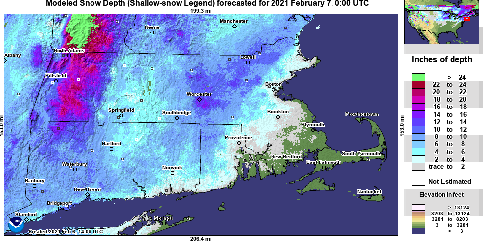
5 minutes ago, Ginx snewx said:
Lol thats current actual depth
Ugh - yup my bad! I looked at 2/7 date but didn't look at the time. (00:00 UTC is right now lol). Grrr... but my comment still applies to the "snow depth" model maps overall. I've never found them to be as accurate as the forecasted snowfall maps when you compare them side by side. I know the depth models try to compensate for compression and melting if applicable...
-
10 minutes ago, ma blizzard said:
These modeled depth maps don't seem to reflect the weather... weather.us has them for a number of models as well and they don't often correlate with the actual snowfall conditions. Then they 'update' themselves after a storm and they make more sense.
-
This has been 14 pages of pure entertainment for a storm that may not materialize.
-
Looks like the dry slot is moving into RI and SE MA, but it may not last long, looks like one more band trying to regenerate and arc towards the NW...
-
-
Still snowing here. Solid 4" of mashed potatoes here in Bristol. Came down pretty good for a couple of hours after a brief mix with rain. Quite surprised I'm still seeing flakes. Winds are picking up again too...
-
 1
1
-
-
7 minutes ago, ScottieBird said:
I got my balls busted on this forum this AM for giving you Eastern folk a preview of coming attractions. Begrudgingly we gotta give the folks at the weather Channel some props for getting a better handle on this forecast than BOX or most broadcast outlets. That being said a thrilling storm. I'm sitting in a parking lot in north Kingstown, RI a few miles west of the Bay watching the snow pile up loving every minute of it.
I don't think it was ball busting as much as you throwing in the towel pretty early on. Yes, the outcome eventually was a bust. But you admit yourself that three miles west of you the forecast is much closer to what was expected. Conditions could have easily changed where the snow piled up a little more east of the bay. It's not like North Kingstown is a bastion of high snowfall totals in the winter time like NW RI.
The Weather Channel and Ch. 10 did end up with a better forecast for eastern parts of RI...-
1
-
-
1 minute ago, TheSnowman said:
THIS IS THE WORST STORM OF ALL-TIME!!!!
I am NEVER Starting an Obs Tread Again!!
7 Hours of Heavy Snow - 2.25"!!!! And SOUTHERN Rhode Island, which gets Crap, has 7.5"!!!!
Don't feel bad, only about an inch here! You doubled up from my house. Looks like it's more of an east/west thing this time around than a north/south.
-
1
-
-
It's been a while since I've seen the radar look so good and the result be so terrible lol... not a 'melt' just an observation. Par for the course down here near the bay.
-
Mixing with rain in Warwick and here in Bristol now.
 Oh well... less to shovel...
-
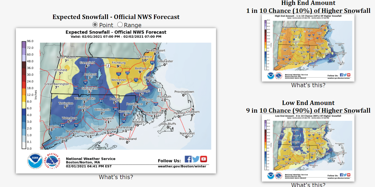
1 minute ago, wxsniss said:
To state the obvious, important to note... that's additional accumulation beginning after 7pm
Many areas of CT already exceeded that map
True - yet the expectation was the worst of this storm would be through 10PM for areas in the coastal plain. That's definitely not gonna happen at this point with this map issued at 5PM. Even my conservative 4-8" is gonna bust here...
-
Just now, Bobbydoppler said:
Looks like BOX is struggling with this a bit...is this a mistake?

There's a point where they stop updating the high end and low end maps, but still keeps updating the official expected map.
-
Updated map from BOX. Also, their 4:45 PM AFD didn't issue an updated short term forecast...

-
1
-
-
3 minutes ago, NeonPeon said:
It's still snowing moderately hard between bands, but it sounds like its raining outside, for how much the pine tree is dripping.
I think the storm was modeled pretty well here, if you ignored the clown maps for actual output. Super low ratio and high melt.
Since its going to rain at the end anyway here though, who cares? It's putting on a bit of a show at least.
Yup, not much better in Bristol. Considering the radar not much to show for it at all. No mixing but whatever is going on with the radar echoes isn't mixing down to reality at the surface. As others have commented, seems more like a March storm than the 1st day of February here. I was expecting 4-8", would surprised if I get that now - still a long way to go though.
-
46 minutes ago, ScottieBird said:
2 miles farther north makes a difference from south facing areas.
Patience...
-
5 minutes ago, ScottieBird said:
Here in Newport the snow is struggling mightily to accumulate. The viz is 1 mile and the ceiling is not all that low. I suspect it'll be raining by 1. The NWS will bust badly here and the PVD cbs affiliate that copied and pasted their forecast will bust also. I should go to Cory's Pesaturo's house 40 miles up the road.
Newport is forecasted at 6-8". I think 4-7" is more realistic. It will stick as rates increase... give it time... but no one predicted 8-12" that close to the coast...
-
You know the GFS is on drugs when I'm in a jackpot zone...
-
1
-
-
5 minutes ago, Fozz said:
RGEM is much improved around here compared to earlier runs.
You're in a great spot in RI for snow in general. I have friends in Cumberland and they always get more than me in almost any type of event.
-
1
-
-
3 minutes ago, geo1 said:
Not a free site though.
-
 1
1
-
-
BOX discussion is very bullish on the front end thump - hence the increase in the maps despite some mixing being forecast.
-
1
-
-
Way up compared to this morning.


-
3
-
-
4 minutes ago, TauntonBlizzard2013 said:
Such a tough forecast down here.... wouldn’t be surprised with 3” or 12”
I think 4-8” is a good call for most in the coastal plain except for right at the coast/cape, etc. Considering the preceding air mass it’s going to be unlikely that mix line gets as far NW as modeled before the precip lets up. As usual with 90% of storms we thread the needle...
-
Took the dog for a walk, about 2-3” on the ground. Light snow but occasionally moderate. Probably could have been a little more but we had mixed with sleet and graupel at times a little earlier this evening...
-
Sleeting in Portsmouth/Middletown/Newport


Quick Hitter Coastal Threat, Feb 7-8th
in New England
Posted
I would still trust the 3K Nam more than the extended range HRRR, though it's getting better.