

bristolri_wx
-
Posts
1,477 -
Joined
-
Last visited
Content Type
Profiles
Blogs
Forums
American Weather
Media Demo
Store
Gallery
Posts posted by bristolri_wx
-
-
-
4 minutes ago, Fozz said:
I'm looking for reasons why this might fail IMBY but can't seem to find any. Perhaps a dry slot or coastal front from hell would screw things up, but I don't see that reducing my total to less than maybe 8".
In Cumberland? You're golden there. That is usually jackpot #2 in RI. I'm in the more worrisome area as usual - the bay is never my friend in snow events.
-
 1
1
-
-
2 minutes ago, Damage In Tolland said:
Here’s exactly what he did
If only he read this forum and knew about the SW trend. His Twitter forecast is 50 pages behind this thread. LOL
-
53 minutes ago, weathafella said:
No one is seriously considering it seriously
The 48HR HRRR is just another map to look at - one thing to consider is that I believe at some point, that the HRRR will be updated and eventually replace the NAM in the future - though I may not be remembering that correctly. So the 48 HR HRRR is kind of the "New HiRes NAM" in testing mode...
-
18Z HRRR for those interested. It runs out 48 hours every 6.

-
2
-
-
12Z GFS incoming... I predict cutter up the CT river... bullseye of 36" of snow in Waterbury...
-
 2
2
-
-
9 minutes ago, wxeyeNH said:
My nephew in Bristol RI has been so excited. Keeps emailing me absurd snowfall forecasts. Now as PF comes in, he starts to come out.
He's probably excited because we haven't had a real snow storm or snow pack down here in over a year and a half...
-
11 minutes ago, RUNNAWAYICEBERG said:
You’d think just one other model would be in it’s camp...just one. But nope.
The DGEX and NGM running on the Commodore 64 in JoeSnowBOS's basement is in agreement. But otherwise, not one other model looks like its in the GFS ballpark at the moment...
-
4
-
-
GEM looks good.

-
5 minutes ago, JoeSnowBOS said:
Lol - GFS most consistent model...tough to go against consistent...EURO may do full cave tonight with sampling better ...GFS will be crowned new king or if wrong EURO says get out of my house...battle Royale here!
GFS most consistent? Not really...
Also, I believe (but not 100% sure) that the NAM had same full sampling as GFS at this point, so if sampling was a variable there should have been a similar outcome, but they are rather different at this point.
-
Just now, DotRat_Wx said:
Oh, no.. Did they put this on air? Yikes
I don't know if that was on air, but it was definitely on their web site, and maybe their Facebook page. I saw a handful of people re-post it last night and this morning on my Facebook feed, and got a few questions about it. Clearly some people thought that was the forecast.
-
From my eyes, GFS looks even more SE at hour 78/84.
-
3 minutes ago, DotRat_Wx said:
Disappointed in you
Technology isn't black and white. Typing this on a new Apple MacBook Air which is incredible. I have Windows and Linux laptops within arms length. People like what they like.
-
8 minutes ago, 78Blizzard said:
We were trashing it a couple of days ago, lol.
The CMC global is as terrible as the GFS at times. But the RGEM and the RDPS are much better, especially on winter stuff here.
-
4 minutes ago, Typhoon Tip said:
RJ Heim was silly for posting that graphic on the web site. It was all over Facebook last night and this morning.
-
1 hour ago, Fozz said:
Last winter was my first in RI, and it was a big disappointment. We had one decent storm in early December (10"), but the rest of the season was completely forgettable, and afterwards the only thing I really enjoyed was my ski trips to NNE, which did get some good storms.
I'm much more hopeful for this winter.
Nice to see more Rhode Islander’s on the forum. We can all ensure the pain of the snow hole together. LOL...
-
 1
1
-
-
1 minute ago, weathafella said:
We’re dissecting the fukking ICON. Get ahold of yourselves!
This is what last winter and the pandemic has done to us!
-
1
-
-
Just now, jbenedet said:
It doesn’t. Was talking about ICON.
I don’t think anyone is “wishcasting” here at moment:
https://weather.us/model-charts/gbr/massachusetts/snow-depth-in/20201217-1800z.html
Switch between the models available and tell us which one sticks out like a sore thumb?
The evidence points right now that the GFS isn’t seeing something the other globals are, including the ICON.
-
Just now, JC-CT said:
Merry Christmas
Hey that’s improvement! It was cutting over Michigan a few runs ago. A few more days it will be off the North Carolina coast before it slings back to Minnesota.
-
2 minutes ago, Fozz said:
You sure it won't be the other way around?
This is the third run in the row that the GFS has done this.
We have had snow storms where the GFS does this 8 runs in a row, and hasn’t come around until it’s already snowing LOL.
Of course this could be the solution but it’s in the minority of guidance at the moment.
-
Does anyone ever look at the 768 HR CFS on Pivotal Weather? Just curious if it's useful for anything. I know the surface/qpf stuff would be useless, but wondering if upper air, 850 temps, is even in the ballpark on the long range....
-
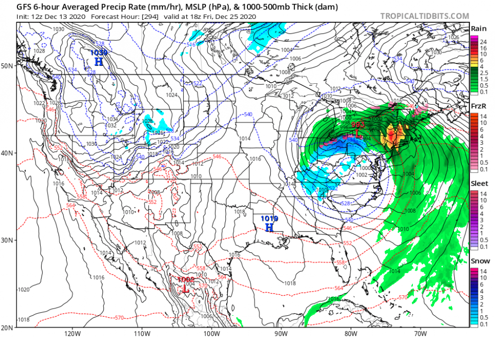
This thing is moving fast. I think 12" south of the pike until you get really close to the south coast of MA and RI seems more reasonable regardless of snowfall map output. To get more you're gonna need really high ratios. Maybe that happens, but I wouldn't expect to see accurate modeling of those kinds of ratios this far out.
-
Just flipped to large wet flakes (where I am) at Rhode Island College in Providence, which is on the NW side of the city..
-
13 minutes ago, HoarfrostHubb said:
3-4” in Jefferson NH. Santa’s Village has a delayed opening
Delayed opening because of snow at Santa’s Village??? Is Rudolph out of town???

-
1
-


Active mid December with multiple event potential
in New England
Posted
I feel like the NAM has a tendency to bring that coastal front at the surface in a little farther than reality in these types of setups. Move that line about 35 miles SE...