

hudsonvalley21
-
Posts
3,893 -
Joined
-
Last visited
Content Type
Profiles
Blogs
Forums
American Weather
Media Demo
Store
Gallery
Posts posted by hudsonvalley21
-
-
1 hour ago, Tpalm5 said:
Good to meet you Rob! It was one hell of a storm. My area in Beaver Dam Lake was mostly unscathed. A few trees down here and there but Fishkill area and Balmville/Town of Newburgh was another story. I was told the picture below was taken in Maybrook. Glad you were ok with the tree that fell in your yard.
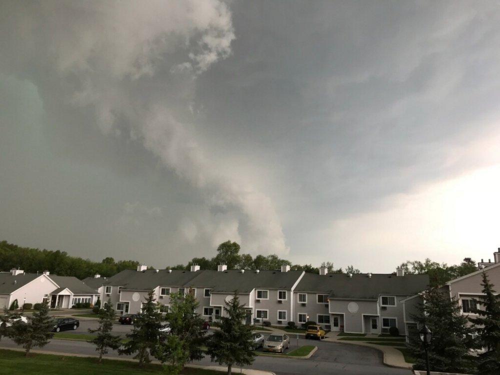
What was amazing in the photo is the green clouds indicating the cloud heights in the cell. My wife was on fostertown road in The town of Newburgh and I was in the southern section of New Windsor, she called me saying it was going Green there at the same time it was green at my location and just to the south of me. That's a wide cell. On the radar screen shot that Rob posted, showed a descrete cell that hit me in new Windsor first that had a strong southerly surface wind then the stronger cell hit with a westerly microburst type wind. In the descrete cell I was able to see some rotation before the rain blocked the view.
-
On May 18, 2018 at 12:00 PM, IrishRob17 said:
Back since about 5:30pm yesterday for me, only out approx 49 hours this go around. I'm feeling very fortunate this morning. One of the linemen working on my house yesterday showed me photos of a house in Sullivan that was in the hail storm...all of the vinyl siding was destroyed and most of the windows in the house were smashed, cars all dented with smashed windows. Just incredible for the northeast.
Glad to hear that you're back up and running. Again as others have offered, if you need anything, we're here. It was a rareatiy where all the indicators were showing an active day was on tap and it came to a destructive reality. With some events, you could never be fully prepared. There are a bunch of people that are feeling very fortunate along with you.
-
 1
1
-
-
Newburgh schools closed again tomorrow. Still 93% of the city has no power. Emergency declaration still in effect. www.recordonline.com
-
Newburgh schools closed for tomorrow. All streets in the city of Newburgh are currently closed under an emergency declaration.
-
Heard a report of an 11 year old girl killed by a fallen tree in the city of Newburgh. Not confirmed tho.
-
Wife is trying to get home and going through Newburgh by the mount. She says it seems like half of the roads are closed and looks like a war zone.
-
5 minutes ago, IrishRob17 said:
I have damage to my house, th top of a tree blew off
That sucks. Hope the damage isn't too bad. Hope everyone is ok.
-
A lot of trees down, roads closed, and scattered power outages in New Windsor, town and city of Newburgh.
-
It defiantly looks like game on. It's also pretty much clear out to our west as per cloud debris. So things will get cooking.
-
1 minute ago, IrishRob17 said:
We've seen setups like this before, where folks keep focusing on the main line of storms not realizing its the discrete cells where the most action is.
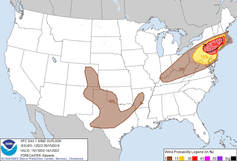
Yup that's where the meat and potatoes are. SPC expanded the enhanced risk. They also mention a possibility of a few winds around hurricane force.
Northeast...
   Thunderstorms are expected to develop and grow upscale from midday
   through afternoon, sweeping eastward across the region with the main
   risk being severe wind.  The potential for a well-organized swath of
   damaging wind -- including a few gusts around hurricane force --
   appears greatest over the enhanced-risk area.  Large hail also is
   possible, especially in the first few hours of the convective cycle
   when storm modes can be more favorably discrete or semi-discrete.  A
   few tornadoes also may occur, whether from supercells or
   QLCS-embedded vortices.
-
1 hour ago, HailMan06 said:
For the first time in awhile we're in the epicenter of a significant severe weather threat. Let's do this!
A section of Upton's AFD, Keep an eye out for descrete cells in front of the advancing lines.
Over northern portions of NE NJ, most of the Lower Hudson
Valley, interior portions of SW CT and NW Middlesex County -
this area should see the highest CAPE (1500-2500 J/kg) and is
under the core of the low level theta-e ridge axis and the EML
(700-500 hPa lapse rates around 8C), so has been placed under an
Elevated Risk for Severe Thunderstorms by the Storm Prediction
Center (SPC). With slightly lower CAPE, and some marine
influence,NYC, the remainder of the Lower Hudson Valley and NE
NJ, coastal SW CT, most of interior SE CT and Nassau County and
portions of NW Suffolk County are under a Slight Risk of Severe
Thunderstorms. The remainder of the area, with the potential for
severe storms to sustain themselves into the area (except for
the S fork of Long Island) is under a Marginal Risk for Severe
Thunderstorms.

Across the Enhanced Risk area, Bulk Richardson numbers are 15 to
25 indicating the potential for isolated supercells ahead of the
main line of storms. Given high Energy Helicity Indices and
Significant Tornado Parameter (both greater than 1) there is
the potential for isolated tornadoes, especially in any isolated
supercells that form ahead of the main squall line.
-
1
-
-
40 minutes ago, IrishRob17 said:
4/30 now goes into my records as the latest date for snowflakes flying through the air.
No flakes here, just a nasty day, 41 deg with showers at noon. It's forecasted to be about 40 deg. warmer wednesday.

-
2
-
-
Snowing heavy now. Dew point jumped from 18 to 28 in one hour.
-
Moderate snow here now with a dusting down. Dew point on the Davis up to 25
-
26 minutes ago, White Gorilla said:
It has been a solid snow season here and I really can't complain overall, but I hate missing out on the fun. Not a flake so far and despite the NWS forecast of 3-5 here, I am not expecting much at all. Dry air, virga, sucks. Reminds me of January 2016.
NWS took down the Winter Storm Warnings for Orange County and put up a Winter weather advisory for 3-5" for tonight. Dew points never got over 18 at KSWF, while HHPN's dew point hit 29. Dry air won this time up here. We'll see if we get the 3-5. Snowhole city so far.
-
32 minutes ago, gravitylover said:
Still nothing other than a random flake here and there, not even enough to call it flurries. It looks like a little batch may make its way in here in a little while though but it doesn't look to be big enough to do more than coat the grass.
I've had about 6 rouge flakes so far today here. I think they were from the snowguns by irishrob17.

Dewpoint holding at 18 all day.
-
1
-
-
12 minutes ago, IrishRob17 said:
The difference between the 0z and the 6z NAM are simply stunning, especially up here. This is why I no longer write forecasts LOL
Current dew pt. is 10 we will have to overcome this dry air up this way. This event is a coin toss as to what we get. Will come down to nowcasting IMO.
-
5 minutes ago, IrishRob17 said:
Puking snow as some would say, I’m going to measure every 5 minutes, this is going to be impressive!
Had some on and off heavy snow showers here. Ground is wet, no accumulation.
-
1
-
-
3 hours ago, Juliancolton said:
Lol

I'll match you.

-
2 hours ago, BxEngine said:
Cant believe i waste these gems on you backwoods rural bumpkins.
")
We ain't all backwoods
")

-
 3
3
-
-
1 minute ago, IrishRob17 said:
My core sample from this event melted down to 1.39”
Just off of the top of my head, I believe that comes to be around 10:1 ratios.
-
1
-
-
13.4 for the final here.
-
7 minutes ago, Pitmaster15 said:
I may have jackpotted here in Sloatsburg
Haven’t gone out to measure yet but I’m pretty sure close to 2 feet. Last few hours were insane. Light snow now
NWS snow reports from Uptonsaid 23.0 from a trained spotter in sloasburg
-
4 minutes ago, nycemt123 said:
Which town are you located in? I've been having flickers for at least the past hour. I'm around Ramapo/Monsey/etc
Sent from my SM-G930V using Tapatalk
New Windsor


Interior NW Burbs & Hudson Valley Second Half 2018
in New York City Metro
Posted
In the town of Newburgh, they re-opened Albany Post Road today. All it can say is WOW to the tree damage in that area. I won't post pictures due to respect of the loss of life on the Monunts Desmond campus and the people that live there.