

hudsonvalley21
-
Posts
3,893 -
Joined
-
Last visited
Content Type
Profiles
Blogs
Forums
American Weather
Media Demo
Store
Gallery
Posts posted by hudsonvalley21
-
-
1.73 in the Davis today.
-
2.17 so far for the month of August in the bucket here.
-
0.77 in the bucket for yesterday. 0.43 so far today, another thunderstorm Just about on the doorstep.
-
27 minutes ago, IrishRob17 said:
Oh, look, its pouring again...
Just got out of the Goshen farmers market in time. They were breaking things down in a hurry. Decent thunderstorm here in Goshen, nothing severe.
-
12 hours ago, West MT. NY said:
I will no longer be a perennial Orange County snowfall jackpot. Wife wanted out of Monroe once youngest graduated HS for reasons I wont discuss but locals understand. My new house will be at the base of Storm King Mtn in Cornwall on Hudson walking distance to the river by the marina at a paltry elevation of 261 ft. It may be for the best as the 48" in 11 days I dealt with last winter screwed up my biceps so much that they are still stiff today and make me less flexible than I used to be when reaching behind my back.
Welcome to the snowhole. In the winter months, you get a great up close look of the river ice at the Cornwall marina.
-
1 hour ago, IrishRob17 said:
Hey guys, please hoist whatever you’re drinking tonight, I lost my old man this morning, fought cancer for close to a year. Slainte.
My thoughts and prayers are with you and your family. Hang in there buddy. If you need something, let me know. God Bless.

-
 1
1
-
-
3 hours ago, snywx said:
0.68" here
Looks like you jackpot. 0.38 here

-
1
-
-
A section of Uptons AFD
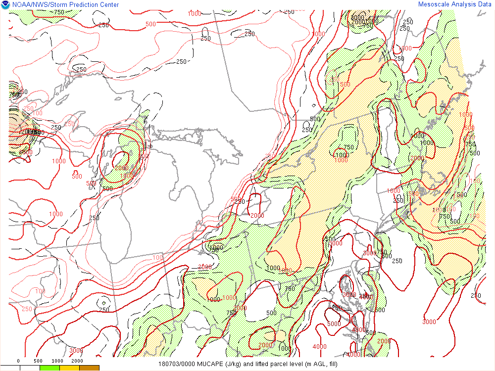
Next concern is rainfall. Operational ECMWF/HRRR have been
forecasting heavy rain bands capable of producing a quick 2-3
inches of rain either just west of or straddling our NE NJ
counties, also additional similar rain bands running through
parts of western Long Island, the lower Hudson Valley, and SW
CT. Have higher confidence in the location of the westernmost
band but not those farther east, and since their coverage is not
widespread and HREF probabilities of 2+ inches of rain was
greatest just west of our area, opted against issuing a flash
flood watch. Depending on where these bands set up, will most
likely have to issue minor flood advisories, but will still
have to watch NYC closely for greater impacts to urban
infrastructure and possible flash flood warnings to address any
direct impact of that magnitude.
-
24 minutes ago, snywx said:
Upton..

Pretty juicy, basically 3-4" for Orange County.
-
10 hours ago, IrishRob17 said:
Middletown, near Tower Dr

Seen the same while I was driving on 17 in goshen to Middletown. I thought I briefly seen a scud cloud, couldn't see much while driving. At home in New Windsor, 0.16 in the bucket not much in this area vs Middletown for precip.
Edit, with frontal passage, 2nd thundershower came thru, total in the bucket for today 0.48
-
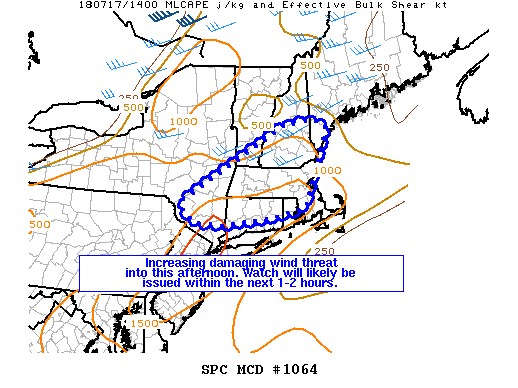
Mesoscale Discussion 1064
   NWS Storm Prediction Center Norman OK
   0935 AM CDT Tue Jul 17 2018

   Areas affected...Portions of New England and southeast New York

   Concerning...Severe potential...Watch likely

   Valid 171435Z - 171630Z

   Probability of Watch Issuance...80 percent

   SUMMARY...Bands of thunderstorms are expected to intensify through
   this afternoon, resulting in an increasing threat for damaging wind
   gusts. A watch will likely be issued within the next 1-2 hours.

   DISCUSSION...Regional radar data illustrate a broken band of
   thunderstorms extending from southern New Hampshire southwest
   towards the Hudson Valley late this morning. This cluster has
   persisted along the southeastern fringe of a subtle shortwave
   impulse (embedded within larger-scale cyclonic flow) over New
   England. Ahead of these storms, visible satellite suggests gradual
   low-level destabilization, evidenced by a slow decrease in wave
   clouds and an increase in boundary-layer cumulus. Amidst a very
   moist air mass (e.g., regional 12Z soundings sampled PWs around
   1.6-1.9"), further surface heating should promote MLCAPE values
   around 1000-2000 J/kg through this afternoon. In turn, thunderstorms
   are expected to further intensify over the next several hours.

   Relatively uni-directional deep-layer wind profiles, combined with
   30-40 kt of mid-level flow, will encourage lines of storms capable
   of damaging winds, especially this afternoon. Considering this
   growing severe potential, watch issuance will likely be needed.

   ..Picca/Guyer.. 07/17/2018
-
.77 in the bucket from the first round, well needed.
-
12 minutes ago, gravitylover said:
And... there it is. Lightning, thunder and heavy rain. Woot woot, dusty hardpan trails ought to be gone for at least a few days
") and the freshly cut lawn won't brown out.
and the freshly cut lawn won't brown out.
Ground is so hard and bone dry. Hope some of this soaks in. There's another cluster out to the west, we might get into some of that too.
-
2 hours ago, snywx said:
Once the storm passed I went out to inspect. Turns out the tree closest to the pool was struck. It created a nice crater in the mulch as well as some fresh cut wood.
Some tree damage, 2 dead squirrels lol..
All is well bro thank you for the concern tho. The only legit casualty was all the cable lines coming into my house were fried. Spectrum came out, replaced the cables now all is well.
Great to hear everything and everyone is ok

-
3 hours ago, IrishRob17 said:
My son was home yesterday afternoon when the thunderstorm worked through and texted me about a very loud clap of thunder that woke him up. He found what was struck close to the house here in the park

WOW thank god there was nobody around there and all is good at home.
Hope snywx is ok , still nothing from him.
-
Severe Thunderstorm Warning NYC071-079-042000- /O.NEW.KOKX.SV.W.0017.180704T1936Z-180704T2000Z/ BULLETIN - IMMEDIATE BROADCAST REQUESTED Severe Thunderstorm Warning National Weather Service New York NY 336 PM EDT WED JUL 4 2018 The National Weather Service in Upton NY has issued a * Severe Thunderstorm Warning for... Northeastern Orange County in southeastern New York... Western Putnam County in southeastern New York... * Until 400 PM EDT. * At 336 PM EDT, a severe thunderstorm was located over Cold Spring, and is nearly stationary. HAZARD...60 mph wind gusts. SOURCE...Radar indicated. IMPACT...Expect damage to trees and power lines. * This severe thunderstorm will be near... Newburgh and New Windsor around 400 PM EDT. PRECAUTIONARY/PREPAREDNESS ACTIONS... For your protection move to an interior room on the lowest floor of a building. Torrential rainfall is occurring with this storm, and may lead to flash flooding. Do not drive your vehicle through flooded roadways. && LAT...LON 4151 7400 4150 7400 4150 7399 4146 7400 4144 7398 4148 7394 4145 7389 4133 7394 4132 7396 4136 7423 4156 7409 TIME...MOT...LOC 1936Z 111DEG 4KT 4142 7400 HAIL...<.75IN WIND...60MPH $$ MD -
A few CTG strikes here from the cell over Cold Spring. No rain yet but can feel the cool outflow from the easterly gusts.
-
1 hour ago, snywx said:
Lightning just struck my pool. Took out my cable. I literally fell out my seat
Thank god nobody was in there. Hope you have a fresh pair of underware to change into. Hope everyone is ok.
-
54 minutes ago, BxEngine said:
Opening my stuff now, since it seems storms are gonna ruin at least part of the day. Might as well drink. Lol
I second that. Going to pop one open and grab the pool float, rain is off to the west from me so far.
-
1
-
-
2 hours ago, IrishRob17 said:
That storm collapsed like frozen broccoli in boiling water.
Didn’t get a drop of rain here. What a pulser that cell was
-
17 minutes ago, IrishRob17 said:
Continuous thunder here from that cell sliding last just to my north.
Wall cloud came thru here a few minn ago. no rain or wind. Alot of rumbling to my north and west. Daughter said there's heavy rain in Goshen now.
Flood Advisory
National Weather Service New York NY
527 PM EDT TUE JUL 3 2018

NYC071-079-119-040030-
/O.NEW.KOKX.FA.Y.0040.180703T2127Z-180704T0030Z/
/00000.N.ER.000000T0000Z.000000T0000Z.000000T0000Z.OO/
Westchester NY-Orange NY-Putnam NY-
527 PM EDT TUE JUL 3 2018

The National Weather Service in Upton NY has issued a

* Flood Advisory for...
  Northern Westchester County in southeastern New York...
  Northeastern Orange County in southeastern New York...
  Western Putnam County in southeastern New York...

* Until 830 PM EDT.

* At 527 PM EDT, Doppler radar indicated heavy rain due to
  thunderstorms. This will cause minor flooding in the advisory area.

* Some locations that will experience flooding include...
  Newburgh, Peekskill, Walden, West Point, Cold Spring, New Windsor,
  Gardnertown, Montgomery, Fahnestock State Park, Putnam Valley,
  Woodbury, Orange Lake, Washingtonville, Firthcliffe and Highland
  Falls.
-
1 hour ago, IrishRob17 said:
Odds are rather slim tonight
Yup, it looks like we're capped.
-
1
-
-
7 hours ago, IrishRob17 said:
I'm braced. How high with the heat index go will be the game now.
Can you convert your snow measuring table to a heat index table.
 For today only picked up 0.62 in the bucket since midnight. Just missed out on the heavier downpours.
-
1 hour ago, Juliancolton said:
The HRRR goes gangbusters with downpours later tonight between about 2 and 7 am, lollis to 2". I have about .4" in the gauge so far. The more the merrier if we must go into Death Valley mode for a week+.
Looks like that might verify. There’s some training areas of thunderstorms out in Pa. heading in our direction that will be here in a few hours.


Interior NW Burbs & Hudson Valley Second Half 2018
in New York City Metro
Posted
0.33 in today's bucket.