NTXYankee
Members-
Posts
390 -
Joined
Content Type
Profiles
Blogs
Forums
American Weather
Media Demo
Store
Gallery
Everything posted by NTXYankee
-
Well I can get why Ohio people have their own discussion, the main thread for this storm is Chicago, Chicago, Chicago and all points around. Typical of any other event in the Ohio Valley if it doesn’t impact Chicago it’s not worth discussing. I seriously hope this storm isn’t a massive ice producer here, would be devastating but not as confident we avoid that along 71 as I was earlier.
-
Hoping for above normal temperatures and well below normal snowfall but, I live in Ohio so I’ll just prepare for another winter that goes from November to May.
-
Yeah no thanks, I’d rather have a weekly tornado outbreak over more snow, we get enough of that already that won’t leave until almost May.
-
Send Mother Nature a text, she apparently lost her calendar
-
Having moved to Ohio from Texas I can say for certain that if either of those two places were included in a transfer I would have learned to deal with it and moved there just for the weather. However, I was speaking of the sunbelt in general. I can’t tolerate 6-8 months of cold and snow then a crap shoot for the other 4-6. My ideal area would be NC or Texas again. I literally had everyone in Texas that I worked with ask why Ohio, now I know why, people don’t move this far north unless they have to.
-
Just like people the storms moved to the more desirable part of the country.
-
It didn’t but your fantasy weather model or whatever you’re using doesn’t know. Last I checked going from one cutoff low to another isn’t a change in pattern.
-
It’s all a mirage.
-
So when is the next cutoff low set to sit and spin for days after this one? Probably a good thing that models show no 70’s or 80’s through at least the 20th and CPC says below normal. Would hate people to have the impression the pattern changed.
-
Are you surprised? There is no end in sight to the pattern we’ve been in since April.
-
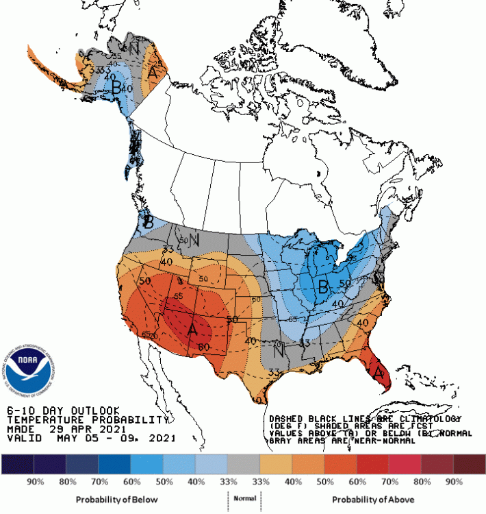
Look on the bright side, they added another layer of blue to the map through the 9th and added more blue area through the 14th. It’s not the darker shades yet but give it time.
-
Colder and coats on Memorial Day, why stray far from what appears to be the norm this year.
-
-
The pattern changed, you must be looking at an early April map.
-
LOL. I guess if you blinked you missed it. 50’s is far from a normal high in May for this area which is what shows up after Wednesday and the same pattern we can’t get out of. I heard 3 rumbles of thunder yesterday so going by 2021 standards I’m above average for the year.
-
lol on a pattern change. After midweek next week we apparently go back into the dumpster, GFS has also apparently decided the Euro is right.
-
lol, no
-
If I saw snow in June, July, or August. There would be a for sale sign in front of my house that day and head south. Unless that is hail being recorded?
-
This aged well...
-
I don’t care about active, sure storms would be nice but I live in Ohio and Central Ohio to be exact. We either watch states around us or within other parts of Ohio get storms. If it doesn’t start active here, it’s not going to happen the rest of the season, happens every time. I just want the blowtorch now. And yes I am cranky and impatient it’s April 20th not November.
-
It never ends and is now just annoying
-
The GFS had the same thing this morning in its 0z run last night, the normal upper low stuck and not going anywhere soon. This talked about pattern change gets more pathetic the closer we get. A 2-3 day warm up isn’t a pattern change.
-
I can do one better at this point and say thunderstorms used to be a thing in April. I have yet to hear one this year. Don’t worry though we’ll have our new normal back if the GFS is right. The first weekend in May could feature a sit and spin upper low with well below normal temps again. Some pattern change...
-
lol I don’t think the help we need is in the cold and miserable category, Mother Nature has proved the last several years now she can extend winter into early May.
-
May 2022? Not sure 2021 will offer much hope at this rate.


