gman
-
Posts
315 -
Joined
-
Last visited
Content Type
Profiles
Blogs
Forums
American Weather
Media Demo
Store
Gallery
Everything posted by gman
-
Grateful to get 0.44" of rain in a gusty thunderstorm. Temp dropped to 74 degrees. More storms west of us. Looks like a few storms to dodge at the concert in Clemson.
-
We only got 0.11” at my house last night. That puts me at 2.21” for the week. We need about 20 inches to end the drought. As always, the heavier rains are isolated. For example, my son lives in Clemson. He is up to 4.31” for the week and 7.88” for the last 30 days, which is 4.10” above normal.
-
I love the RainDrop app. It is amazing on accuracy. https://www.raindrop.farm
-
We are up to 1.43” so far. Decided to open our windows and not turn on the tv this morning. Been listening to the beautiful sounds of the rain, birds chirping, and the light breeze bringing music from the chimes. God is blessing us with His voice through nature. Doesn't get any better.
-
It looks like at least another couple of weeks before we get any measurable rain. The winds are already drying things out. I pray it is not a long, hot and dry summer. I cannot afford another water bill like I had for April!
-
We have been blessed with 1.88” so far, with another 0.50” possible.
-
We got 1.04” of rain in a strong storm last night. Much needed rain.
-
GSP has dropped our total to half an inch. That means I will get less than that over my house near Paris Mountain State Park.
-
We had some light ice pellets early this morning, enough to show up on my truck bed and the roof. Where did that come from?
-
Light snow and 33 degrees. Nice surprise.
-
Well, it is the cliff diving discussion, which is meant for complaining. Growing up is my point. Thank you.
-
Thankfully, I figured out how to stop getting post from those of you that continue to spew out filthy language on a family friendly forum. Seriously folks, can you think about what you are saying before you say it? Do you think you are being funny with using poor and bad language? Be a human being and think about others. If you choose to ignore being civil, may the next snowstorm miss you again!
-

January 30th- Feb 1st ULL and coastal storm obs
gman replied to JoshM's topic in Southeastern States
https://twitter.com/TheJDubTweets/status/2017362122636738861?s=20 -
January 30th- Feb 1st ULL and coastal storm obs
gman replied to JoshM's topic in Southeastern States
It has been the most wonderful and joyful day. This 68 year old weather geek novice was beginning to wonder if I would ever see another good snow. We ended up with almost 6" of glorious powdery snow. To top it off, I was able to get several great workouts in while shoveling and blowing snow off the driveway, all while listening to the late great Sam Cooke and to Bruce Springsteen. Thank you God for treating this getting older man to such a day! Life is short people. Live the question. Enjoy the moment. Finish strong. -
January 30th- Feb 1st ULL and coastal storm obs
gman replied to JoshM's topic in Southeastern States
Almost 5” at my house. I expect the area just 10 miles east of me toward Spartanburg will get at least 8” before the storm moves out. -
January 30th- Feb 1st ULL and coastal storm obs
gman replied to JoshM's topic in Southeastern States
Funny story. I was having a difficult time getting the ice from last week's storm off part of my driveway. The lawn maintenance guys arrived at my neighbors house on Thursday with a leaf blower. I thought they were nuts trying such a thing. They busted up the ice in no time. I proceeded to do the same thing. Had that ice busted up in minutes. It was a festivus miracle! I have already blown my driveway three times this morning, but am having a difficult time keeping up with the heavy accumulation. That is a good problem to have. Now, if I could keep the snow from blowing in on my carport. It is already a slick as glass. I am to hang extra long shower curtain liners for the next storm, which I think we will get this winter. -
The “I bring the mojo” Jan 30-Feb 1 potential winter storm
gman replied to lilj4425's topic in Southeastern States
I live in Greenville about 2 miles north of Wade Hampton/Taylors. We are up to 3" here and it is still coming down hard. -
The “I bring the mojo” Jan 30-Feb 1 potential winter storm
gman replied to lilj4425's topic in Southeastern States
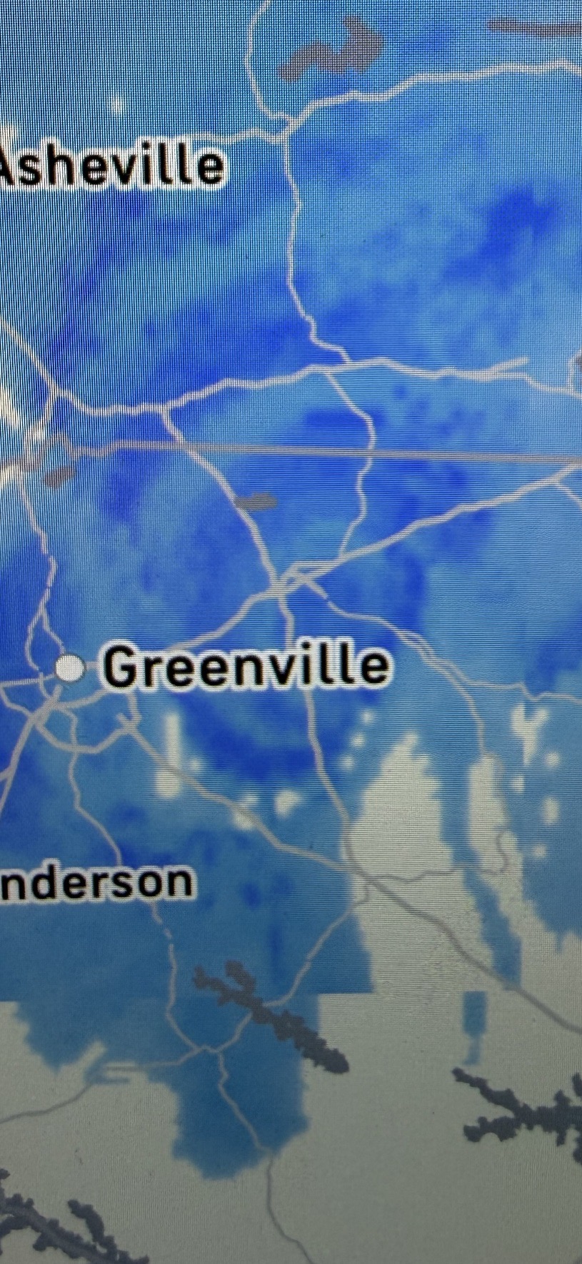
I am looking at the radar/satellite combo for the Upstate. Am I seeing things? It looks like a convective circulation over central Spartanburg County. Is that the ULL?
-
January 30th- Feb 1st ULL and coastal storm obs
gman replied to JoshM's topic in Southeastern States
I am looking at the radar/satellite combo for the Upstate. Am I seeing things? It looks like a convective circulation over central Spartanburg County. Is that the ULL?
-
The “I bring the mojo” Jan 30-Feb 1 potential winter storm
gman replied to lilj4425's topic in Southeastern States
GSP NWS has just updated their discussion. If what they say happens, the Upstate to Charlotte is going to get some heavy snow. https://forecast.weather.gov/product.php?site=GSP&issuedby=GSP&product=AFD&format=CI&version=1&glossary=1&highlight=off -
January 30th- Feb 1st ULL and coastal storm obs
gman replied to JoshM's topic in Southeastern States
Light snow in Greenville. Temp is 30. I am not impressed at all with the radar returns. I assume that will start filling in and expanding as the ULL moves in? -
The “I bring the mojo” Jan 30-Feb 1 potential winter storm
gman replied to lilj4425's topic in Southeastern States
That map has been cutoff on the western side. -
Would your ma be happy with your filty language? Seriously, this is a family friendly website. Can you clean up your post?
-
The “I bring the mojo” Jan 30-Feb 1 potential winter storm
gman replied to lilj4425's topic in Southeastern States
When does the HRRR come out? -
The “I bring the mojo” Jan 30-Feb 1 potential winter storm
gman replied to lilj4425's topic in Southeastern States
Yes!