

Typhoon Tip
-
Posts
43,406 -
Joined
-
Last visited
Content Type
Profiles
Blogs
Forums
American Weather
Media Demo
Store
Gallery
Everything posted by Typhoon Tip
-
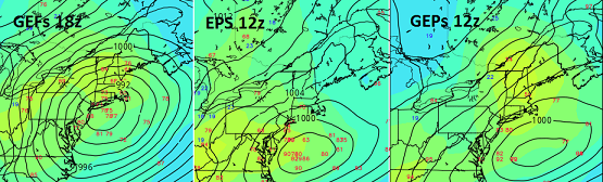
Alright ... let's try a different tact this go around. There is an important signal for the dates in the title, one that I would characterize as a medium impact for now, with both higher and lower correction potential. Firstly, I realize the villagers are bit edgy if not incensed by the debacle that's gone on in the models, wrt the 28th system. I mean I get it. Unfortunately, nature is not going to wait for you to get over it. The language contained is not intended to sell cinema here. It's should be treated as an early awareness, outline some observations for consideration regarding the 3rd/4th event. Technically being inside of 7 days ... (5.5 or so days 18z, and this is in shotgun sites of our region ...), this is not an atypical range to preliminary a threat assessment. That is what this is for. It is important to compartmentalize these recent disappointments as being unrelated to this prospect - because simply put ... they are unrelated to this prospect. I will be happy to come in here and add the operative adjectives should this evolve in a clear and obvious d-drip direction.. --------------------------------------------------------------------------------------------------------------------------------------------- Basic synopsis: A deeper more expansive full latitude trough than has been observed in recent weeks if not months, appears slated to be ejected out of the semi permanent -PNA nadir over the SW... resulting ultimately in a fast moving QPF loaded Miller A type low genesis and track that brings it to our doorstep by the end of the 3rd. It is lifting N out of the Arklotext region, which climatologically that's brought flooding problems in springs, owing to proximity to warm inflow/Gulf of Mexico moisture source, resulting in an enormous PWAT transport. We have ample cold on the N side of this particular low. Presently modeled in both the Euro and GFS operational version ... a cryo sufficiently cold air mass is in place across PA/NY NE England, back built by +PP in Ontario, already as this system is modeled to approach. The cold side of risks a hefty amount of liq equiv in S/IP/ICE over perhaps a 12 to 18 hour period. Models: You are all aware of the 00z, 06z, 12z, and this recent 18z blends of the GFS ... but for the sake of discussion: monster in that particular guidance source. Negatively tilted with over a 100kts of massively loaded jet transport. The exit/lateral/entry regions of this thing are extraordinary, even as it is being force by the antecedent and on-going -PNA footprint, to open up a dish pan trough structure when it cross through - again...as GFS is arranging things. This is the most intense version of this system I can find, moving the low track over central LI to SE Ma ~ targeting deep interior for goodly dose of IP/ZR and snow W_N The Euro made a pretty significant correction N... having about half to 3/4 of the GFS amplitude, targeting DC to NJ for a significant snow event. Perhaps the most use/telling are the ensemble means... The GEFs seem to parrot the operational version, having an impressively large deep solution that varied from SE Ma to the Benchmark over the last several cycles. The EPS has made significant attempt toward more structure, as has the GEPs... Perhaps someone can post those images ? All these are improving over cycles, with the EPS and GEPs making a more convincing lurch today. They also have an interestingly varied spread in intensity, with some of them getting rather exotic - this I feel owes to the incredible diabatic inject this system has as a ( really ...) early spring, deeper latitude origin, riding N into a cold antecedent/seasonal latency in place in our region. Hence the high ceiling potential. The "super blend" of these is almost a perfect scenario ... but that's likely just a present artifact of noise. Caveats emptors and the lower ceiling potential: 1 .. the -PNA footprint is raging through next week, and March 4. System ejected out of the west will need to supply ( most likely...) there own mechanical power to overcome being lift over the negative (NVA) aspect of the SE ridge. 2 ..In reality, I suspect some de-magnification shit will occur. ...I don't believe the GFS is necessarily right with 20" in Albany and 3" of sleet and ZR from Kevin to myself... But, the blend of the GEFS/EPS/GEPs is trending to a much, much more deeper full troposphere ejection through the W. As comparison, that's a much different animal compared to the over-sell that took place with the 28th and is also the biggest mass modality we've seen perhaps since Dec.
-
Feb 28th-March 1st long duration Miller B threat
Typhoon Tip replied to George001's topic in New England
I'm actually a heart full enough to hope NYC gets a band of moderate to heavy for 4 hours. -
Feb 28th-March 1st long duration Miller B threat
Typhoon Tip replied to George001's topic in New England
Y'all might wanna start entertaining the notion that this was just a model canard all along ...and the region may end up in a C-2"er when all's said and done. If you were to draw a trend line starting 3 days ago, ...it seems like such a line would end up down there... In fact, the trailing N/stream is buckling a bit more in the flow behind this ...whatever it is not - looks like a WAA IB that's over QPF populated by American guidance types at this point - looks more like it could be an interesting 2 hour burst... but I suppose to the two just get melded together as one ordeal. -
the 12z Euro closes the gap on the 4th about half way to the GFS' intensity and track. Still misses ...but clocks D.C. to NJ ... It's funny... I could see this coming into a consensus for that event, then... en masse, the same consensus then has to answer to the same destructive interference pattern and ends up wrong anyway? I mean we're not out of that meat grinder pattern then. The difference between it, and this 28th debacle... , is that the latter one is far more powerful as it ejects out of the S/W - which is one of the main problems with the 28th player. ..at this time anyway. The 28th is really teetering. It's on life support but not really dead. If more relays in over the next couple of cycles, then it may take it back into an Adv scaled ordeal.
-
Feb 28th-March 1st long duration Miller B threat
Typhoon Tip replied to George001's topic in New England
aH...that one... I remember that one. 24" forecast at bed time was 4" of grits -
Feb 28th-March 1st long duration Miller B threat
Typhoon Tip replied to George001's topic in New England
Oh my god... don't get me started. There was one... I wanna say 1987, late January. There was a 4th period ( 4th period!! ) blizzard watch issued. 'beep beep b'beep beep - beep beep b'beep beep,' "...THE NATIONAL WEATHER SERVICE, TAUNTON MASSACHUSETTS HAS ISSUES A..." started running along the bottom of the television main networks and TWC, every couple of hours, upgrading to a warning for some kind of dystopian cryo apocalypse. Turns of phrase like, "...RIVALING ANYTHING EXPERIENCED SINCE 1978..." I photo-fuckin'-graphically remember that, man! They had snow approaching 2 feet ... damaging winds ... power outages ... coastal flood where that was applicable... for what would amount to two straight days before hand. The storm was supposed to begin overnight and pretty much render society halted by the next morning ...all over central and eastern Mass/CT/RI... So I was at the gym playing in pick up games, basketball, on the eve of the all-mighty. I kept going out in between games to check the lamp light in the parking lot to see if it was starting. These random flakes began along side these big IP pellets. The sky was glowing that kind of butterscotch hue that you see at night when it's snowing hard, and I even thought at the time, '...better get finished and head home...' Another hour later it's like 9:15 pm and the gym's ( highs school) was emptying.. I left the energy of the gym to walk home, but entered a still eerily calm realm. And not like the 'calm before the storm' vibe, either ...More like 'something's not right,' kind of bad feeling. The glowing hue in they sky became dark around the horizons. I remember that when I was really little in western Michigan...when lake effect was ending ...or perhaps the band just shifted away... that city glow in the sky would remain over overhead, but turn black toward the horizons. I hated that... The snow never started back up once I saw that affect. But...thereupon that faithful walk home I opted to put it out of my mind ... similar ( actually) to how we tend to ignore the writing on the wall to this very day in this pass-time LOL... So I'm home and waiting patiently for Harvey Leonard's 11 pm. I knew he'd be leading the news cast as by then... the storm awareness and coverage was at an all-time fever pitch. Mind you, ... civility was only 9 years out of the Cleveland Super-Bomb, and the infamous Feb 5-7th Blizzard here in New England... It was sensy. As the credit were rolling ... Harvey pops in for the teaser, "Big big changes regarding our storm. I think you'll need to hear this" - I think a shot of raw battery acid must've flooded my tummy upon hearing those words... for I knew. Oh, I knew. Still, I tried to think, 'how can this be an even bigger storm if the horizons turned dark....?' haha So he comes on and the other shoe falls. "Looks to me, after studying the very latest guidance, like the worst of this will be down near the Cape and Islands, with far less impact as you go north west" ... ' I bet that wrong. It can't be ' There was at the time I crawled into bed 10 minutes later, still what amounted to epicosity warnings. Dawn breaks, partly sunny with stiff wind, 9F ...zero snow having fallen. Thank you for playing the 1980s state of the art weather modeling game! yee haw. Went from no school for a week, to get your ass dressed and walk in a gelid 9F face flogging wind, NOW! -
Feb 28th-March 1st long duration Miller B threat
Typhoon Tip replied to George001's topic in New England
You're not getting banned dude ( if you're not kidding..) But the 36 buns you earned on the thread opener ... beyond being a "10 top historic" achievement ... can you finally once and for all learn from that and the journey since? There is nothing wrong with having started thread for this concern. I did too - it was far more conservative, however. Even so...it was a bad call on my part - most likely... I went for a moderate event, with a possibility for more. Most likely, wrong. Anyway, threads should be started for anything that is interesting - the decision to pin this was not yours. That's on moderation... I think others are conflating pinned threads with access/success in storm entertainment - and that then puts them in a situation where they need to blame others... etc. But this isn't about the thread being composed. It's about the exotic hyperbole as though it really happening... I've tried to constructively encourage you with objective reasoning. But then when you reply to it, "...thanks, good advice, but I'll stick to my guns," in the face of the incontrovertible, that sounds like you're ... well, if you got an issue, we'll support you. We're compassionate. But if you don't and this your stubborn election to be cartoon fantasy monger in here - I think collectively most that enjoy this pass-time would rather not It might be time to reign things in a bit. -
Feb 28th-March 1st long duration Miller B threat
Typhoon Tip replied to George001's topic in New England
Today might be the biggest event until ...whatever fails (it feels inevitably) on the 4th. No, I'm in neg head hyperbole mode for fun - hope no one takes this too seriously. I plan to have fun the rest of the afternoon as a coping mechanism for this embarrassing circumstance. I mean, thousands of views, and hundreds over in posts and it just seems we should have known better - And I did. I just lapsed at the time (about 4 days ago) Everything I explained yesterday and today and the day before is true. The 12z Euro spelled it out in cinematic form, perfectly. Like I said, I blundered initially 4 days ago for allowing my self beguiled by that tsunamis of model runs that day. But the scaffolding for this thing was all wrong back then, and still is... And that stuff I've been calling "de-magnification" as a euphemism, was also true, all along. Forget why-for the models do that, they do - I drop the ball on awareness to that, too. Those two failures "constructively interfered" far better than any S/W could for this p.o.s., and I really fell asleep at the wheel. I was asked this morning what I thought this would be, if pistol was given a b.j., ...and I said Adv or less as the upper limit. I'm pretty much now okay with less, period. I just want to see this thing finally come around the bend into the SW and be fully ingested into the denser more physically realized sounding domain before just not coming in this thread any longer... -
Feb 28th-March 1st long duration Miller B threat
Typhoon Tip replied to George001's topic in New England
You know ...at this point, just for mordant humor it'd be funny to see this end up dim sun with dust ... essentially a blank showing, with 50 pages of a thread preceding. That - I think - would have to be the greatest magnitude achievement ever, in thread size to negative return ratio -
Feb 28th-March 1st long duration Miller B threat
Typhoon Tip replied to George001's topic in New England
We've managed to halve the 'Recent Browsing' count ... let's see if we can cricket this f'er by sundown tomorrow LOL -
Feb 28th-March 1st long duration Miller B threat
Typhoon Tip replied to George001's topic in New England
If this goes on to 3 inches only ( and that may be too much ...) you're sooo lucky. At least you had a few days. Try growing up in the 1980s. There were a lot of multi feet to multi cirrus streaks in 6 hours that decade -
Feb 28th-March 1st long duration Miller B threat
Typhoon Tip replied to George001's topic in New England
If must ... I would call for a light event, or 'minor' on the scale of minor-moderate-major. To me, minor can involve Advisory level and less amounts/impact. Moderate's upper Adv -lower Warn... Major is above that and so on One wild card, which as that implies ... is much lower probability and therefore should not be counted on, is that a stronger relay ...currently coming around the bend over southern Cali and through the SW ... is stronger than previous/recent runs. As I was attempting to describe in that missive, more vorticity kinematics central to that impulse would be an offset to the negative vorticity over the anti-cyclonic curvature - whee the models are attempting to send it over top. I cannot completely exclude that happening, no - -
Feb 28th-March 1st long duration Miller B threat
Typhoon Tip replied to George001's topic in New England
You know I mentioned this earlier in this thread ... that layout does not look like a typical coastal layout. That looks like an overrunning event. I mused at the time that it may actually be similar in layout to what just occurred, if perhaps along a more southerly axis. That's all still the case. I don't know if it's just symbolic, or if there is much actual veracity to that comparison. Interesting Man, I've frankly grown a bit weary of coverage for this winter ... I'm definitely ready for it go away. Unless there's something that can overcome this -PNA grip on our side of the hemisphere, I'm close to the bubble on tolerating this shit much more. There may be some hope - the MJO folks were intrigued in there last weekly publication. This current event may gut punch the Nina and serve as a kind trigger/inflection in its demise. Great! That helps us out for April But you didn't ask me that haha... No, but I think this system's parental/mid level mechanics were always real, but back whence this was more impressively the respective guidance ( or blends there in...) there were two scopes of uncertainty that I myself blundered. The first was... the S-SE warm wall is a semi-permanent artifact of the La Nina/-PNA. We've been in a very well coupled hemisphere since the 3 weeks around Xmas when it broke down and yielded that hybrid Nino look. Point is, it was not modeled to really go away prior to this thing getting injected through as it was back whence. My blunder is not supplying enough obvious recognition to the fact that moving a S/W up and over the top of a ridge arc supplies a -NVA term across all DPVA deltas along the way. We see this as "damping" effect in the cinema of the runs.. Here's what then really "doomed" this guy: "de" magnification ... that's the coup de gras, the 2nd blunder. The models were perhaps over amplified with the main S/W when it was D9 ( no shit!?). That's become a regular/reproducible observation going back several years actually... idiot. Compounding a perfunctory downward correction in kinematics with -NVA concept is a bit much. These 'objective speculations' I feel pretty strongly are more valid than just reaching for explanation. -
Looks like the new GFS is a little weaker aloft but still provides dense QPF for the 4th … which may end up being the third.
-
Feb 28th-March 1st long duration Miller B threat
Typhoon Tip replied to George001's topic in New England
Is this the dependable recurring theme of the noir film where we only consider models that enable our denial? -
Feb 28th-March 1st long duration Miller B threat
Typhoon Tip replied to George001's topic in New England
Oh it’s a slow grind when it does. It starts with a bad run here or there… Then we start getting a general QPF consensus that’s shaving pts. Already down to a high end advisor in general but like if the 0z icon comes around maybe that limps us into a low end warning. snark aside… I think this event has a little of that demagnification stuff going on for other reasons. but it also was probably going to attenuate some just because it’s going over the top of the ridge arc. A track like that imposes physical limitations on amplitude… I’m kind of kicking myself for not recognizing that for five days ago with this. I don’t know if you can tell but my mood on this is really down ha ha ha but it’s because of that blunder -
Feb 28th-March 1st long duration Miller B threat
Typhoon Tip replied to George001's topic in New England
Heh 0Z Iconoclastic model with 6-8” of course -
Feb 28th-March 1st long duration Miller B threat
Typhoon Tip replied to George001's topic in New England
It seems like this is turning into one of the most vivid examples of the “de”magnification phenomenon yet, where the models correct grandiosity down to gerbil turds -
Feb 28th-March 1st long duration Miller B threat
Typhoon Tip replied to George001's topic in New England
The euro was probably not right… That said I do think that this thing has a lowered potential fwiw -
I don't think so, if I were asked at this time and "mood" (admittedly) I dunno... the NAO is gone. Red Herring all along. It may return to those retro white dreams it was along those prior runs, now tossed upon the trash heap of modeled fantasies - a heap that is in my opinion far larger than any modeled NAO success stack. There were/are 2 primary factors driving this late winter, as we turn page into a early spring. - La Nina/-PNA persistent foot print - The happenstance of a cold loading event across the Canadian shield. That latter aspect is really the only thing protecting us from early 'warm bursts' ... perhaps similar to 2017, 2018 ... 2020..etc. Dice rolling on NAO by the physical results of model ( so to speak...) just very recently perhaps added to that, but thinking back on that modeling escapade... It was always perfect. Think about that. A perfect NAO requiring at D7-10 lead. Uuuusually doesn't end very well. I think whatever happens moving forward, don't count on assistance by the NAO. I was just looping the 10 days of the 12z deterministic Euro, and it really has very little NAO blocking sufficiently above neutral 500 mb anomalies to matter, W of Iceland, the whole way. That's hugely different than some of these charts just 4 or so days ago. ... anyway, I guess there is some small consolation in knowing that it can just as easily return and help force matters - the probability goes in both directions. But I hate to roll eyes ... the clock is ticking on this season, perhaps at a faster rate than normal years do to the most persistent and dependable of those two signals above: the ENSO/-PNA In fact, the D10 Euro is almost a warm burst. Not sure how this effects ( if any) the GFS Mar 4 idea. The 12z GEFs have so much weight in favor of a bigger event there ( not just the operational), that all this may be irrelevant for that event. That said, the GEFs 12z mean doesn't have much NAO moving west across the Basin any longer either ( thru D10). It tries beyond but this f'n thing is can-kicking big time. Just stop. We don't even need an NAO in a GEFs/operational GFS scenario. So I guess this afternoon op ed, in the spirit of commiseration ..., has two facets. The first being, the longer term signals are returning to a warm one for the month of March. Without the NAO, and the cold in Canada surely exhausting in time - have to monitor the EPO loading pattern for the first couple of weeks of the month - not sure how there can arouse any other impression. The second aspect regards yet another lesson in overrated NAO. I mean it plays a role and can be a modulator, but it's really still just the Pacific ( transitive wave mechanics - been trying to explain this lately but who wants to think in an environment of fantasy and escape lol) and fact of the matter is, we can do fine without it. We just don't have the footprint hemisphere to do so this go of it.
-
Feb 28th-March 1st long duration Miller B threat
Typhoon Tip replied to George001's topic in New England
... all in good fun but still... I don't know if I'm ready to throw "Ralph Phillips" under the bus for a combination of La Nina, global climate change, and denial entirely. Maybe just shove 'im in front and see if he dives out of the way in time -
Feb 28th-March 1st long duration Miller B threat
Typhoon Tip replied to George001's topic in New England
And the beauty is...its crossing through its performance 'event horizon' like right now ... and it sniffs this solution? I'll be in the March thread if anyone needs me - -
Feb 28th-March 1st long duration Miller B threat
Typhoon Tip replied to George001's topic in New England
See ...this is why the Euro model is such an asshole now. First, it takes a hint and blows it out of proportion... and creates this charming sociopathic argument to it's peers to join in, which they do to a greater extent that faithful afternoon. But, now that the great conning narcissist has everyone deceive by guile, it leaves them in a convincing lurch: "Suckerrrrs". What jerk! -
Feb 28th-March 1st long duration Miller B threat
Typhoon Tip replied to George001's topic in New England
I've been warning ... correction vector is pointed toward less. I'm grudgingly accepting the prospect for more, and this is just one run and all that blah blah-blah blah. But, this is still facing certain large scale circulation type challenges... Adding that too this aspect of "model magnification" we've referred to in the past, sort of makes this a smoking gun for a "top 10 bamboozle" event. We'll see -
Feb 28th-March 1st long duration Miller B threat
Typhoon Tip replied to George001's topic in New England
How about just "Taunted"soul and be done with it. lol


