

Typhoon Tip
-
Posts
43,388 -
Joined
-
Last visited
Content Type
Profiles
Blogs
Forums
American Weather
Media Demo
Store
Gallery
Everything posted by Typhoon Tip
-
I disagree with the assertion of this being a test of technology for an event still beyond 7 days from now... especially 10.
-
this air mass won't help the SSTs as much as moving the surface stressing NW toward the coast from out at sea. I'd take an 80/70 SE bahama blue stream line flowing air mass before this if I were after packing warm SSTs into the coastal shelf
-
LOL, for a lot folk's sanity ... almost better to engage in other hobbies and/or weather focus' ... then be notified whence the time comes that it's happening. By the way, ... while you were gone - Because the journey in this case is NOT its own rewards. haha
-
It does ... ... which at D7 lead before it becomes critical to sew in the necessities, we're still just picking out fabric and tread. My issue is that the telecon d(spread) is perfect! 7 days of modeling peregrinations to emerge features that are actually favored to be there ... mmm.
-
I would not trust these deterministic guidance ideas east of 100 W across N/A ...beyond D7... LOL, that's what porked us - not anything actually on the chart. Know what you mean tho. Just thought that was funny.
-
It's complex but this warm ENSO phase came on buried inside a hemisphere already steeped in summer season ... That means it is not reaching outside --> not forcing ... or less therein. El Ninos that "start" in mid summer" are differently correlated to those that get going earlier. So, lagged effects on the circulation overall are already in place.. That's the typology. The MJO folk over at CPC are stating that the hemisphere is 'increasingly' more El Nino, which means it is in process of coupling .. Coupling better as the season progresses is the natural assumption. (Coupling in this context means that the oceanic-atmospheric thermodynamics are identifiably linked by historical inference on the R-wave spatial orientation ... which is grad level dialogue . You can have times (transiently) when a warm(cool) ENSO underlies an atmosphere that takes on a circulation mode that is uncorrelated. ...etc. ) Anyway, because the warm ENSO's maturing is taking place while buried , it is thus not as well coupled as it may become later in the season. These current peregrinations of tropics are not being effected yet. Which ... just looking at the behavior of shearing and circulation tendencies below ~ 30 N, it is pretty clear that El Nino is not disrupting the Atlantic Basin as of yet - there's lags going on.
-
By the way... 'super synoptic' is just a phrase I use to mean the non-linear distribution of forcing, often referred to 2ndary..or constructive interference. The pieces are not necessarily 'up stream' in that sense, as the mechanics create a new arena that exists as a result - in which events become favored.
-
I'm seeing a classic super synoptic scenario unfolding myself and have for days to be brutally honest. One can't really use that as a deterministic guidance metric; the models have to emerge the features. But the correction vectors and 'emergence probabilities' will haunt the models in time, and in time should bring this toward an east coastal risk. These model 'hints' and starts are not just noise. Stopping short of "threat" ... but at some point I don't have a problem and most who know me know that I don't give a f what others think - I call these things things when I call them. I'd watch this thing closely if I lived from the Carolinas to Atlantic Canada with equal plausibility - for now. If I have to knock it down, I'll knock it down. Okay
-
I'm getting the feeling that Ineedsnow might actually break the single season posting record
-
I start to wonder if the top 20 or 30% of this warm enso is really the foundation of the elevated planetary state... with the enso on top/elevated starting point - so to speak. sort of a concerted notion with the RONI ideas but not entirely... It's like the flip side of the side coin. The real El Nino is something like the 70th percentile of what these SST are flashing. ha
-
Wake Me Up When September Ends..Obs/Diso
Typhoon Tip replied to 40/70 Benchmark's topic in New England
90/73 here ... -
Yeah... per this run, it was precariously missing just enough to max out the heart ache and hand wringing hahaha. I've maintained from the get go that beyond ~ D6 ... that is entering a "predictive event horizon" - based in no small part on continuity issues with guidance between ORD-D.C. and NF triangulum; that is creating a virtual boundary in time and space beyond which there is zero knowing.
-
every run has different ideas on the spacing and temporal-spacing. ...not sold on any one of them - I'm also suspicious that the GFS may be responsive to too much application of beta mechanics causing the track to curve too soon along that model's cinema.
-
I can't count any longer how many times I've gaped in awe at a Bahama Blue pattern ...and thought- if only..
-
It's funny you said this for me, because I was just musing the other day ... pretty much exactly this sentiment. The odds for this sort of thing/tropics working out has gotta be longer than even threading an open wave cyclone in the winter
-
Don't we typically observe the nadir this week ?
-
The problem I have with 'repeat time' or 'over due' and the like is that they are wholly an artifact of linear statistics - taking linear averages doesn't apply to reality. Because, pretend for a moment there have been 30 hurricanes on the EC over 300 years, that means you get to have fun and excitement every 10 years or your due? wrong. All that means is, spanning that particularly sample set, if you divide the total years by the number of occurrences you got the number 10. It really doesn't mean anything beyond arithmetic result - the only thing stopping the definition of an arbitrary number is that yeah ... hurricanes have happened on the EC over that 300 years. Nothing else. If we look back, there are 30 or 60 or 20 year intervals where there may have 5 or more. Then spans with less... It really means vastly more significance if we can identify the eras where the 5 or more (or less..) are favored. Then, if you're cruising through one of those periods and missing out, then "maybe" the "due" has more meaning relative to that period which was suggested to have performed better. But that kind of deeper conditional analysis is not happening in here...lol.
-
You guys commune with your gulf coast and floridian corporate cousins lol. There's an insurance exodus underway. That's the first step imo in 'climate refugee' scenario - so to speak. California's next. Insurance pulls out like a trailer park birth control option signal economic abandonment, ... population follows.
-
Mmm... not ready to say 'likely' just yet. Step 1, 'key slot' check Step 2, -NAO pulse over the western limb timed accordingly ... not quite checked off but hovering the pen Step 3, trough in the Lakes orienting the flow parallel to the coast ... this part is invisible to the layout until maybe 72 hours from now. 96+ would be better.
-
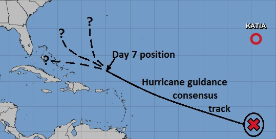
The NAO is slipping negative ... I'm a little 'concerned' (for lack of better word) that we may end up a pulsed resistance to an east turn once we near that supposed D7 position - those that have gone on to become problems for the EC to NF, if there is ambition to see those problems take place you have to at least do this much ... ...which that's like step 1. Beyond D7 is what I like to call the 'predictive even horizon' ...There are model solutions that go out that far, but they and the collection of them et al are no better than guess work - there's not real 'sight' in that space-time.
-
Yup, expo ... And from that, I'm still seeing "predictions" of where we are going that appear to lean linear. Not sure that is empirically supported -
-
Maybe they should name this one "Infamous" then
-
Folks tend to associate temperature to those plus and negative signs of those index modes but it really is never about temperature. It’s about mass continuity in the atmosphere; it just so happens to be that colder(warmer) temperatures tend to associate with either of those signs, respectively.
-
Wake Me Up When September Ends..Obs/Diso
Typhoon Tip replied to 40/70 Benchmark's topic in New England
I suspect we're getting a upper cat 3+ type major along the MDR out of 95L ... It's intriguing that all guidance agree on dropping off the would-be tempest, whatever form, around the outer Bahama bus stop at the end of the run.. The pattern above that/hence forth needs work. The GFS idea is really just a climate parabola and not really set up by the climo features very well. BUT, ...all being D9+ makes any analysis really futile. It's an interesting relay though - to me - because the hemispheric +AAM is rupturing around that D8-12 period, punctured by a new trough settling into a wholesale +PNAP sweep over mid latitudes. The former delivers the cyclone west - if the latter can get the memo this would become one of those ominous early signal deals. -
Yeah ...my write up above may have been a bit too long for the attention .. but 95L has this (bold). The probabilities for this system seems to seesawed quite a bit, with these first 4 or 5 days at higher than normal confidence, and then abruptly dropping to no confidence beyond. There's two domain spaces ( obviously...). The tropics. Then, outside the tropics. When a system is in the tropics, there's a predictive "event horizon" so to speak.. Can't see over the boundary, which occurs along the track where accurate spatial and spatial temporal timing (both) of westerly mechanics begin to interact. The jet is active around 50 N across the continent, ...modeled to be that way from ~ day 5 or 6, out to the end of the run. However, the models are positioning waves from S of Alaska to the N Atlantic, with poor continuity. So long as that remains so, there's virtually no way to assess how a 95L's future will interact with the westerlies. Just in general audience ... for every system that long tracked and ended up 60 naut mil N of PR through the key slot, ultimately to make a destiny with an EC landfall, there have been 99 that curved harmless out to sea - figuratively speaking - or turned back W and smacked Florida.


