

Harry Perry
-
Posts
976 -
Joined
-
Last visited
Content Type
Profiles
Blogs
Forums
American Weather
Media Demo
Store
Gallery
Posts posted by Harry Perry
-
-
5 minutes ago, RogueWaves said:
Can anyone name a storm that had more counties of MI in a winter headline??
Thinking back, I do remember the entire upper and lower peninsula having a winter storm warning.. but the date is evading me. Maybe one of the GHD systems?
-
14 minutes ago, michsnowfreak said:
SE MI forecast is so damn tricky with this one. Last real ice storm here (not counting minor glazing) was Apr 15, 2018. And before that it had been several years. Ironically the most ice storms were centered around the least snowy decade (1940s).
I definitely think IWX and DTX will be adding and expanding overnight looking at the majority of the 00z data.
-
 1
1
-
-
2 minutes ago, Harry said:
The best thing about that winter was that lake length les band that got pulled in our way via that meso low.
Ofcourse that ice storm in April a few years back ( 17 or 18? ) sucked as it took out half a tree that crashed through my deck railing and deck out back but thankfully soft landed on the house. Terrible sound when it crash landed and thought it had taken out my bathroom window upstairs which thankfully didn't.
Damn, that’s no good. That storm (believe it was 2018), was strange around here. You could go out Pennfield/Bellevue and it was awful, but the minute you turned onto Raymond Rd and headed south to Michigan Ave, very little in the way of ice. Two different worlds minutes apart.
-
 1
1
-
-
7 minutes ago, RogueWaves said:
I edited my post to say the last bad one I remember for Calhoun was Dec of 2006. There were one or two more in early '07 and a minor one during the mid-Feb 2011 storm. Dec '06 could've cost me my life as I drove my car straight through a massive tree downed across the entire road in the dark.
Wow, glad you’re alright. Where about was that? I remember that storm well. Massive trees uprooted everywhere, almost looked like wind damage from a severe storm vs. ice storm. Lots of damage along M-37 toward Bedford. Went to my grandfathers to check on him and see if he needed a generator (behind Rombaughs auto sales) and it was like a scene out of a movie - every tree on his property was nearly bent over backwards.
-
1
-
1
-
-
11 minutes ago, RogueWaves said:
Maybe not for Calhoun. Remember, we dodged a major bullet with the Dec 2013 ice storm. Might be time to pay for that.
You make a valid point, it’s been a while since we’ve had a doozy.
-
1
-
-
30 minutes ago, SolidIcewx said:
00z Hrrr now has ice amounts flirting with warning territory for Wayne county
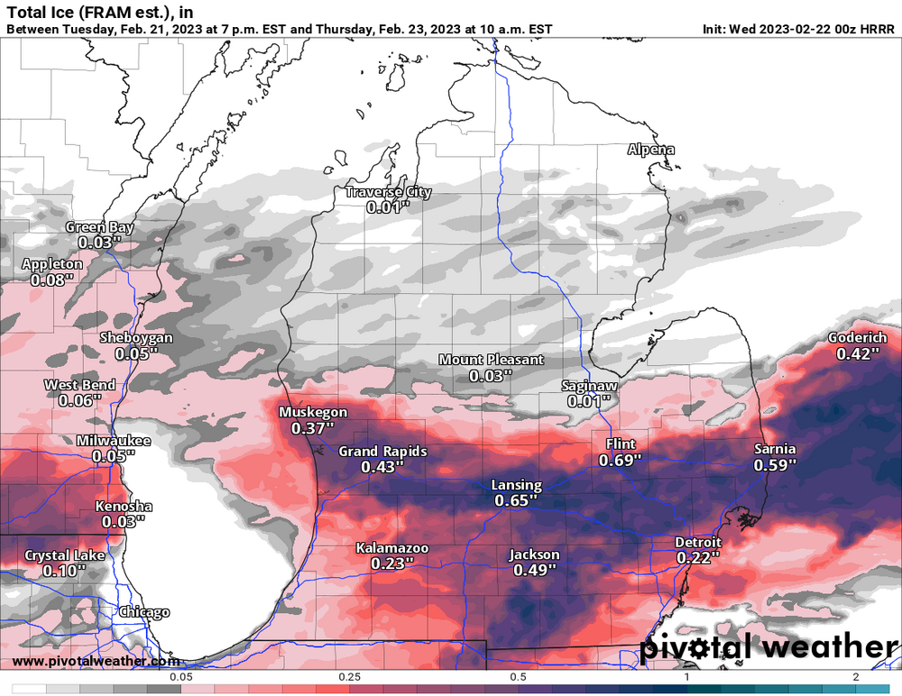
Atleast the HRRR isn’t that bad compared to other guidance. Wouldn’t be too prolific if that run verifies.
-
Servicing my generator for this ice storm to not materialize tomorrow, y’all can thank me later

-
 2
2
-
-
Just now, ILSNOW said:
18z Euro FRAM

 Not liking the looks of that.
-
1
-
-
GRR goes ice storm warning for our area, calling for up to half of an inch. Lovely.
-
2
-
-
21 minutes ago, hardypalmguy said:
Hoping for a crippling ice storm. Set us back to the stone age.
The 12z RDPS would do it.
-
GRR beginning to side with the short range guidance on less ice and more plain rain, atleast along the 94 corridor, shifting highest chance of icing further north. They’re also really beginning to question if the ice will even materialize due to the heaviest qpf occurring earlier and the temps being so marginal - so plenty of good news, hoping it stays that way.
-
1
-
1
-
-
17 minutes ago, StormChaser4Life said:
Wagons north. Lol
Should be interesting to see what happens here.
Love that the front can indeed make it north of the MI/IN/OH and IL/WI border in the middle of winter, but never come spring… Stays along I-80 Every. Single. Time. Keeping the weather trash here and 70° and sunny 50 miles south.-
1
-
-
00z NAM sticking to its guns.
-
Last Thursday at approximately 4:30, it was 29/30° With moderate FZRA, and it was freezing quickly on contact. Fortunately it only lasted about 45 minutes to an hour but turned everything into ice for the evening and the glaze stuck to the trees (could hear the crunching on the wind). My immediate thought was, “enough of this.” A week later I see that could’ve just been the appetizer. One hope is that most of the QPF will fall earlier in the day as plain rain prior the temps slipping just under that point of instant accretion during the late afternoon/evening as precip wanes.
-
1
-
-
6 minutes ago, Natester said:
Thanks. Much of that freezing rain is going to run off with temps so marginal.
I would agree, if temps end up a degree or two cooler though, it will not be pretty.
-
Ended up with 6.5” total here in Battle Creek. Definitely a bit more than expected. Fine flakes this morning turned into monsters this afternoon/evening. Nice event, was also nice that it was still - no wind and not all that cold 31-32° for the duration. Trees are all plastered with snowfall.
-
2
-
-
Ironically enough 21z SREF mean increased from 3.7” from 15z to 5”. Excellent lift in the DGZ for most of the duration of the event, wonder if heavier rates will lead to some dynamic cooling to help ratios out a bit. Going to go with 4” of concrete locally.
-
1
-
-
00z, 06z and 12z GFS all look like complete trash. Nothing really to speak of for anyone in the sub except for maybe an inch or two of slop for DTW. Ontario looks good. 06z Euro holding steady with a swath across I-69, but really local with not much outside of it. Still plenty of time for this system to fall completely of the tracks, which I have a hunch it’ll do.
-
9 minutes ago, michsnowfreak said:
Very interesting. Most of the roads here are snow covered/drifted/rutted and slippery
Just got home, I live in a subdivision in the fringe of city limits. Not bad at all.
-
1
-
-
1 minute ago, LansingWeather said:
Man, I wish i was able to be in buffalo today. I flew up for the november storm
Me too! That would be an experience over there. Think it was the NAM Forecasting 94.5” over there. Just bizarre.
-
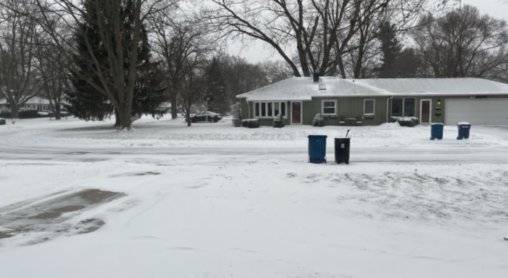
Everywhere and I mean literally everyone here closing early due to the “snow storm”. Garbage pick up is today and they called it off. No one on the roads/highway. Some ice on side/back roads but all other roads and highway is clear. Very windy, but visibility is pretty good. Filtered sun at times, very little if any snow accums today.
Feels like a normal Michigan winter day.
-
1
-
1
-
-
This is rather lack-luster so far, and the back end of the snow is approaching quickly.
Will be interesting to see what transpires, but the 3-6” by 1am looks to be in dire jeopardy.
-
1
-
-
10 minutes ago, Hoosier said:
Compare the 03z RAP to the 21z RAP and 15z RAP and you'll see...
Notable uptick for sure.
-
9 minutes ago, HillsdaleMIWeather said:
GRR held off on expanding any headlines, I think they might in the morning
I think they’re sitting in a good spot now, I could see an upgrade to blizzard warning if the low continues to deepen more rapidly earlier than expected. Overnight shift or mid morning shift would likely pull the trigger on that. Or if they don’t they will just as the winds begin to die down and the snow rates drop Friday evening - in somewhat typical GRR fashion
 . One thing to note is (Bill Marino GRR AFD) mentions the uncertainty with 3+ hour of 1/4 mile visibility/less in the WSW zones, but I would say that it’s close enough to more than likely going to happen in the Eastern zones just as much if not more as the SLP deepens over the east side of the state.
All headline verbiage and technical jargon aside. It’s going to feel like a blizzard.
-
1
-

February 21-23 Major Winter Storm
in Lakes/Ohio Valley
Posted
30° and moderate rain here. Have just about a .10” on elevated surfaces. Lots of run off. Temp was 32°, dropped to 29° when the rain started and now leveled off at 30°. Roads are fine but they’re also warmer so I guess that’s the silver lining.