

Harry Perry
-
Posts
976 -
Joined
-
Last visited
Content Type
Profiles
Blogs
Forums
American Weather
Media Demo
Store
Gallery
Posts posted by Harry Perry
-
-
46 minutes ago, RogueWaves said:
"Watch and warning map looks interesting.. even DTX pulled the trigger on a warning. GRR will be updating and issue a warning after 6” has fallen and there’s been 200 accidents CWA-wide haha."
THIS!
Different holiday, same dumb-a$$ b-players at the helm. This hard hitting wet snow is the worst to drive in. The impacts will exceed most events the 94 corridor has witnessed in quite some time. I wish I could laugh along with you, but I commute out there and don't like to see people unawares
Honestly it’s not a laughing matter either, why the need to keep from informing the public of dangerous travel is beyond me and the NWS’s take on it? “It’s not going to be a crippling storm, just 5 to 7” with locally higher amounts” for the first time since last season. Stupid.
I respond to calls on I-94 from the 104 to 112 mile markers (firefighter) so it’s very irritating when this happens and GRR doesn’t inform of it (or informs of it broadly and underplays the event and the possible dangers of it).
-
 2
2
-
 1
1
-
-
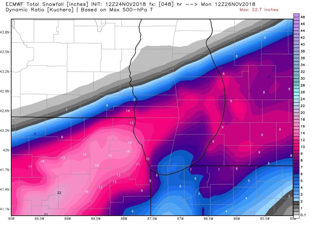
Area Forecast Discussion
National Weather Service Grand Rapids MI
316 PM EST Sun Nov 25 2018

LATEST UPDATE...
Synopsis/Discussion/Marine

.SYNOPSIS...
Issued at 316 PM EST Sun Nov 25 2018

- No big changes to the going forecast.

- The snow will be disruptive, but not crippling, thus we kept the
Winter Weather Advisory and did not upgrade to a Winter Storm
Warning.

- Monday morning commute will be much slower than normal.

- Confidence still high on a plowable snow.

- Heaviest snow between I-94 and I-96 where 5 to 7 inches expected,
locally higher.

- Lake effect snow expected Monday night through Tuesday night with
some accumulation possible mainly west of US-131.
.

&&
Watch and warning map looks interesting.. even DTX pulled the trigger on a warning. GRR will be updating and issue a warning after 6” has fallen and there’s been 200 accidents CWA-wide haha.
-
 1
1
-
-
Fun storm to watch unfold.
Bad storm to have weak warning to the public that heavy snow is on the way (GRR). I’m going to write them in NWSChat and mention the latest 12z model suit and their thinking. IMO we need a WSW for at least the I-96 - I-94 counties ENE. First large storm of the season, holiday weekend.. etc. We don’t need another 130+ car pileup.
-
1
-
1
-
-
Just now, Stebo said:
HRRR much more realistic representation of the evolution across MI too as the low slides south of here.
This.
-
Intriguing. The Euro is holding strong... someone’s going to bust, but I will say - the Euro does have a more natural look to it versus some of the other guidance that just seems to dry up on the east side of Lake Michigan whilst the storm is still deepening.
-
2 minutes ago, CoalCityWxMan said:
Still think it’s overdone, but impressive to say the least

Unreal. The range of solutions is giving even the best forecaster a run for their money.
I’d hope that GRR and DTX put out at least a SWS or WSW this afternoon. You can always go to an advisory - but with tomorrow/tomorrow night being a big travel time, it would be wise.. especially if the Euro and like models happen to verify.
-
1
-
-
Should have a little bet better handling this evening with ROAB sampling. Models are still all over the place. Euro has accumulating snow (heaviest) in NRN Illinois/Indiana/Ohio while GFS has the heaviest 200+ miles to the north near Kalkaska, Michigan. That’s quite the discrepancy being roughly 48 hours from the event.
-
1
-
-
Agree with Buckeye on this...
GFS, GEFS and Euro on board for a decent shot at several events in the next 10 days. All too early to really pin down, but the first looks to be next Tueaday-Wednesday.
-
1
-
-
Ugh... couldn’t even squeak one decent day in this week (Monday was nice until it wasn’t). Nothing like trying to work outside on projects that require dry weather and it rains (or mists) every 3 minutes. Today was looking promising - again, until it wasn’t. Hi-Res has the rain arriving here at 18z.
Hopefully it rains this weekend... oh wait, it will... and it will be a soaker Friday, Saturday and mostly all of Sunday with highs around 60 maybe 70 but doubtful being on the north side of this... Typical. Worst of all, can’t even get a thunderstorm out of these systems.
Excuse my rant. Looks like the pattern will be changing to more steady summer like weather next week... until the next ULL moves in for the rest of July
 (where were these in January?)
-
2
-
-
We have a relatively hard area to forecast - the lake has quite the influence on weather. Can’t believe it’s been that long since a tornado watch here. Wonder if that trend will continue for this spring and summer as well.
I know one thing for sure - we have had A LOT more thunderstorms thus far in 2018 than in 16 and 17 combined.
-
4 hours ago, Torchageddon said:
The 2nd worst thunderstorm I've experienced was during the summer of 2003. It was just as the sun had set and had prolific lightning and high winds. I would like to figure out the date of that one so anyone from southern Ontario/eastern MI who remembers some good ones from that June-August give your take. I don't know how to search for t-storm events by region or where to start.
These archived radar images seem to come from the Iowa Environmental Mesonet.
I’m pretty sure the storm you’re talking about is the same storm I remember as well. I just looked it up a couple of months ago.
We we had a stationary boundry/warm front slowly advancing north. Had a 20% chance of an isolated storm. At this age, I was glued to the local radar channel in hopes to see a spec of green and red form lol... Against the odds, one lone storm developed just off the Lake Michigan shoreline near South Haven.. it developed pretty quickly and then went severe warmed shortly after. It was moving almost due east and was following the Van Buren/Allegan county line. My grandparents lived in Bedford, Michigan - just north of Battle Creek and roughly a mile or so from the county line (Calhoun county/Barry county which is due east from where this storm was coming from). “Let’s go to grandpa and grandmas and watch the storm”, my mom said. Remember it like yesterday. My mother and I jumped into the car around sunset and made the 20 minute drive... on the way, just before dark, we crossed a Veterans Memorial bridge that gave quite a good view from all angles, I remember seeing prolific lightning to the WNW... and then I saw a flash to the north and then another to the SW. I knew at this point storms were developing everywhere near that boundry. Got to my grandparents and the lightning was nearly constant. Went inside and looked at the radar - I couldn’t believe my eyes. There were three tornado warnings and a handful of severe thunderstorm warnings; storms everywhere exploding (severe weather wasn’t expected). The storm grew closer - steady rumbler and continuous lightning by now. Sirens went off and another tornado warning was issued for Calhoun County. I remember the local Mets saying “if you’re in Bedford - TAKE COVER NOW! 85MPH winds were being reported in Hickory Corners (only about 15-20 minutes to my West). At the same time, the specific radar was set on velocity with the rotating cones to show rotation in place of the hook. There were three inbound with several peppered around. First legit time in my life I thought the big one was coming. Power flickered - lightning was the most intense I’ve witnessed to date. Every strike sounded like it was within a few hundred feet of the house.
Picked up nearly four inches of rain, lost five healthy large trees and several downed lines. We didn’t make it back home until close to 1AM and the ONLY way I remembered what year it was - the song that was on the radio on the way home after the broadcaster talked about some of the damage reports he was getting from around the area - It was Dilemma by Nelly lol. Came out in the summer of 2002 - became a hit in the spring/summer of 2003.
The storms eventually prompted a small tornado watch as well. It was only from Barry County to Maccomb and south to the MI/IN/OH border. High winds and dangerous lightning moved across the state that night, and it was 85° and miserable the next day. I’ll look again and see if I can’t find the date and radar. I remember finding it and couldn’t believe I actually found it. Those storms stuck out in my head a lot like May 29th 2011 did. Oddly enough, both events were due to a quasi-stationary boundry with shortwaves riding along it - similar to our current pattern.
IIRC, I had to be on my computer to pull the data and radar images/loop from IEM (Iowa Environmental Mesonet Archive), my phone couldn’t do it.
-
1
-
-
Wouldn’t be surprised to see the slight risk expanded farther north for Monday evening, especially if instability builds.
-
12 minutes ago, CheeselandSkies said:
Interesting that E. IA/N. IL/S. WI are in the SPC 70% area for thunderstorms from 04Z-12Z tonight, but area radars are completely quiet at the moment.
Majority of short range guidance shows covective development along the front by roughly 06z. Interesting note, that same guidance is still thinking there are storms ongoing in north central Indiana at the current hour and there is nothing - so this should be an interesting night lol.
-
 1
1
-
-
Can’t wait for this awesome weekend...
-
1 hour ago, cyclone77 said:
Ahhh, noice.
Rapid transition towards a more summery look continues. The leaves on the trees are growing quite quickly, and should be pretty much full grown by later this week. The wind makes more of a rustling type sound now as it blows through the trees instead of a dull roar like when they're bare.
Yeah, sure is nice to hear rustling over the roar.
-
On 4/21/2018 at 8:32 AM, Spring 2018 Is The Worst said:
I'm really thinking we're gonna have the coldest summer on record too by a long shot. Might be hard-pressed to even hit 80 in July.
You’ll be so over the heat and humidity within the next month or so that you’ll be complaining of it.
-
1
-
-
25 minutes ago, IWXwx said:
Yes, I was going to point out that the latest run doesn't depict the double digit negative anomalies after Sunday-Tuesday like it had in previous runs, although it still shows an average of below normal temps for the next two weeks.
00z runs were terrible weren’t they? Let’s hope they don’t revert (they probably will).
-
Long range GFS shows more zonal flow and warming after next week. I don’t see anymore ridicously cold (30’s for highs) on GFS (other models - do still show it - 12z GEFS says 20’s for highs next Monday - STOP.) CIPS saying we’ll jump from this to above normal by June - May being the transitional month.
At this point, though - if we started May out with 70’s and 80’s (not likely to happen) - I would still personally call 2018 - the year without spring in modern history.
-
1
-
-
9 hours ago, NWLinnCountyIA said:
Oh yeah, this right here is just great. Actually this is EXACTLY what I want to see. This trough just decides that it needs to park itself over the eastern conus, because why on earth would we want southern flow anywhere in the central US?

Too add on to this, Massachusetts has higher dews than the YUCATAN PENINSULA.
Atrocious. Long range looks like garbage. Any bit of warmth keeps getting shunted like the plague.
-
1
-
-
4 hours ago, GreenBo said:
We had a week like this in April 2011. I think it snowed on 22nd?
I remember that, though we had several bouts of warmth through the month as well - but just as much cold... but not this cold lol.
April 2011 was interesting, we had 30’s and 40’s for a few days, then 70’s and 80’s for a couple days, then back to the 40’s for a week - then by the end of the month, we locked into the 70’s - right after a bout of 30’s and 40’s for highs.
I really hope that we start getting some signal of a warm up in the long range - but as of now there’s not much hope. (Thanks again, Greenland Block).
-
2
-
-
5 hours ago, WestMichigan said:
For those of you not liking the current weather pattern this is what GRR had to say today.
The first week of April (1st through 7th) is very likely to end up
colder than normal.  Curiously, over the past 30 years the first
week of April was colder than the NCEI normals nearly twice as
frequently as it was warmer than those normals. So, this should be
no surprise. If fact, in the past 10 years only 2008 and 2012 were
warmer than normal during the first week of April.
Interesting... considering yesterday was the coldest Easter we’ve had within the last decade. Last year and 2016 were both 70° on Easter.
-
1
-
-
Blocking.... anyone? Plenty to go around.
Theres one of two things that will probably happen when and if this pattern breaks - and one would highly favor the sub. Either this blocking stays put and we carry on through a very chilly spring/early summer (near record breaking if all stays put... yuck)... OR we get a pattern change and we will make a sudden change from 30’s and 40’s, to 70’s and 80’s within a weeks time. The good about that is the amount of cold air that will still be to the north - thus a very good severe weather season.
Hard to say what will happen though. With any luck blocking will stay in place and it’ll be in the 50’s for Memorial Day.
-
1
-
-
2 hours ago, KokomoWX said:
Question about Holland Tulip Festival...
Vacation has been planned to come for the Tulip Festival. With what seems like a slow start to spring, anything I should be aware of? We are going for an early morning photo tour before it opens so we have concerns about the development of the tulips.
Well, a lot can happen between now and cinco de mayo... but at this point I’d keep looking for atleast a solid week of 50-60’s for that to take place, and we’re 5 weeks out so plenty of time for that to happen.
-
1
-
Nov. 25th-26th Midwest Snowstorm Potential
in Lakes/Ohio Valley
Posted
Heres GRR thoughts on opting out of a warning locally.
I still think it’s warranted, especially with what’s headed this way downstream.