

Harry Perry
-
Posts
976 -
Joined
-
Last visited
Content Type
Profiles
Blogs
Forums
American Weather
Media Demo
Store
Gallery
Posts posted by Harry Perry
-
-
32 minutes ago, DaveNay said:
Is there a 12 month sliding window record?
Sent from my moto x4 using Tapatalk
Good question, that I’m not sure of.
-
3 minutes ago, sbnwx85 said:
I'll be gathering two of every animal and changing my name to Noah.

Can you imagine if we squeezed this event in before the new year? Would’ve blown records out of the water... literally.
-
 2
2
-
-
7 minutes ago, ILSNOW said:
NAM disagrees
Yuck.
32° and heavy rain. Welcome to winter.
-
 1
1
-
-
4 minutes ago, josh_4184 said:
Southern Mich better gas up the ole' generators if the ice were to verify even half of what its outputting.
Despite what the models are showing on ice... it will be marginal at best. Heavy rates (Likely end up as sleet), marginal temps (31-32°), high wind, time of day... all will make it hard accrete what is modeled. Still worth watching though.
-
1
-
-
8 minutes ago, Hoosier said:
Of course the Canadian rolls in with this right after me going DAB

Insert eye-roll here..
-
 1
1
-
-
Ahh.. this time of the year is the best. Cold nights in the 20’s and days in the 30’s.. until a storm system moves in and we stick on the warm side of it time and time again.
One word for the outlook of December, “Dank”.
-
Only thing keeping this from being a low end warning criteria snow around here is the warm ground. Maybe we can get some good rates to overcome some of this, but we shall see.
-
50 minutes ago, Baum said:
just decided to check in and see what the pre winter banter was. Good things seem to be happening. carry on..............
Checked medium/long range, instantly thought the same... haha
-
1 hour ago, Hoosier said:
Actually have a signal for some lake effect rain here on Friday. Makes me remember that the 19 year anniversary of the October 7-8, 2000 lake effect snow is approaching. Not gonna snow this time though.

Give it time.. fwiw long range GFS has us cold and CFS (lol) have us in heavy winter jackets fighting an arctic blast on Halloween haha.

-
1
-
-
Nasty looking cell. Listening to the scanner over in that neck of the woods. Many taking cover, but not hearing any damage reports as of yet.
EDIT : NWS measured 1” hail at the office.
-
Several short range runs showing explosive development around 00z tonight.. fortunately the MCS has weakened to the point where the atmosphere should remain untapped over this way, but later on I’m trying to find what the models are seeing that’s driving explosive development along the boundary other than the LLJ.
-
Have a strange suspicion of a stagnant stationary boundary sitting just south of the MI/IN/OH/IL border in coming days/weeks.
You know.. the kind that keeps it miserable and in the 50’s with low clouds and rain on the north side, meanwhile 50 miles south it’s sunny and 80? Yeah.. I can feel some of that garbage coming... (and see it becoming more persistent on the models). No ******* thanks. I understand it has to set up somewhere, but it always sets up in the same spot every year. Gets old. Bring on summer.
-
1
-
-
23 minutes ago, beavis1729 said:
LOT canceled the warning.
Bottom fell out of it over there... looks like it’ll be more of the same over here. Latest short range models keep most areas east of I-69 warm enough for rain and even a couple others showing less than and inch at most for SWMI.
-
12z GFS backed off on amounts this side of the pond with 2-4” at 10:1. Looking a little more realistic vs. NAM and RGEM.
-
Wow.. winter just won’t let go.
-
Second half of April is going to bring lots of early summer weather for many. Long range models have been pointing that way for a while now and it may actually come into fruition. Almost feel a 2014/2015 summer incoming. Nothing over the top, but some good warmth and good storms spread out over the four month period.
-
Certainly looks better than last year.
-
With the amount of rain headed this way from southern Illinois and Indiana (which will be here by 12-2pm), our chances are slim for severe as some of the short range guidance (HRRR) has shown. Best bet is southeast of the state.
-
This will be an interesting one to watch unfold. Historically these types of setups end up busting up here due to cloud cover but still may yield damaging winds along a thin low-topped convective line that may form and push east along the cold front. If we end up with more sunshine and manage to get 70°, then I’d be concerned being in close proximity to the triple-point along with moderate instability. The ingredients are definitely there for a sneak attack haha.
-
2
-
-
GRR actually issued a winter storm watch for 65mph wind and rain haha. I do believe I am living in the twilight zone right now.
-
.DISCUSSION...(Today through next Monday) Issued at 330 AM EST Tue Feb 12 2019 The word of the day is "messy." Currently, a large precipitation shield is encompassing much of the Lower Great Lakes with a deepening surface low over central Illinois. A warm nose captured nicely by AMDAR soundings continues to inch northward, with dual- polarization radar data suggesting the snow/mixed precipitation line is currently along a line from Muskegon through Grand Rapids to Lansing. Mainly freezing rain has been noted south of the aforementioned line, with ASOS-reported ice accumulation rates in the neighborhood of 0.05-0.1"/hr along I-94. At our office in Grand Rapids, we`ve been enjoying a snow/sleet mix for the past hour or so. Easterly winds are gusting to 30-35 mph leading to blowing snow (where it is snowing) and efficient icing.
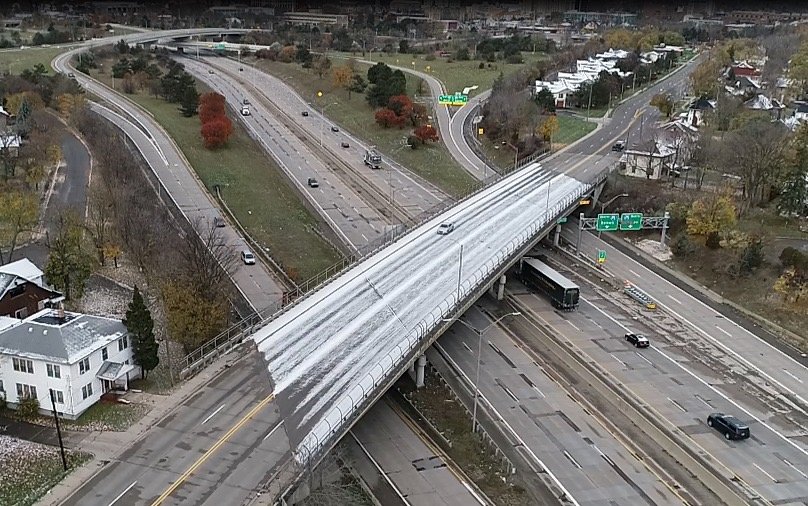
Oh boy... Jokes on us southern counties haha. Have roughly a quarter inch of ice and still going. 29°, light/moderate ZR. Brisk east wind. No warning. Here comes the big one and no ****’s given haha
*Edit*
If any of you are readers or posters from roughly I-80 north to I-94 from Toledo to Chicago - just consider this an ice storm warning criteria event. Wouldn’t be surprised to end up with closer to a half of an inch with higher amounts locally. Roads are absolutely trash. Major highways are iced over and dangerous. If you don’t have to travel this morning please don’t. Making a report now via NWSChat.
-
11 minutes ago, hlcater said:
I’d upload the 2 pics I took but amwx is like nah. So theyll have to wait until later.
Nice isn’t it? Max size 1.95MB. Party like it’s 1999.
-
1
-
5
-
-
18 minutes ago, Maneee said:
I was reading this feeling immense appreciation for LOT. They improve every single year and they keep us appraised of all forecast changes and thought processes.
Agree 100% - one of the best offices around IMO.
-
5
-
-
I think it’s intriguing to say the least in why GRR issued a warning for 4-7” of snow for their northern zones tonight but issued an advisory for 6-10” for their southern zones two weeks ago... There is some favoritism in the CWA. It’s alright, give us to IWX or LOT. I wouldn’t complain haha.
Looks like things will get d ICE y around here tonight. Strong WAA should dump a quick 2-4” followed by an extended period of ice (.10-.30”) as the warm nose pokes into the area followed by a brief shot of rain as the the low travels overhead, but some guidance keeps it cold enough for a mix I-69 points west. Then we should get into the trowel feature with some lake enhanced snow to drop another 2-4” as temps plummet and winds ramp up. Looks rather nasty around here for tonight/tomorrow with 25-35mph wind.. Hoping the RAP and NAM are being a little too agreesive with the ZR but with a large warm nose (48° at 925mb) and sleet looking minimal at best with lack of refreeze before precip makes the surface - this kinda screams freezing rain. We shall see.
-
1
-

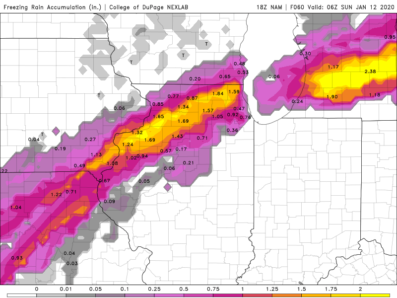
January 10th-12th Winter Storm Potential
in Lakes/Ohio Valley
Posted
If you take into account what all the models are showing - they’ve honed in on our area. I’d say I-96/69 to I-94 will be hardest hit if surface temps do actually make the drop quicker and deeper than prior thinking. I’m seeing some upper 20 figures by mid afternoon in your area and around 29-30° here. Will be interesting if that actually pans out.