Harry Perry
-
Posts
976 -
Joined
-
Last visited
Content Type
Profiles
Blogs
Forums
American Weather
Media Demo
Store
Gallery
Posts posted by Harry Perry
-
-
ILX always seems to have higher SBCAPE, lot of corn nearby? Some of the highest readings I’ve ever witnessed came from ILX where the dew points always seem to be higher than surrounding areas.
-
22 minutes ago, CheeselandSkies said:
Nothing like a 4/26/91 analog over your house in Wisconsin...in late July.
Convective mode likely won't allow for something like that, but wow.

Wow is right.. hell of a sounding. Never know, tomorrows storm mode could start off with some SUPs, likely nothing like the Andover event but the ingredients are definitely there.
Would expect a bump to ENH for most of us overnight and tornado probs increased a bit. I was looking at my local sounding and have a ton of hail matches. Hard pass on all of that nonsense.
-
37 minutes ago, SolidIcewx said:
It’s definitely pure jet fuel that’s for sure. I’ll be back home tomorrow so hope for a good storm at least even tho the area has taken a beating as of late. 00Z is Hawt

It’s our time to shine.
-
 1
1
-
-
47 minutes ago, Stebo said:
Tomorrow looks legit, I could see MDT level output especially if the HRRR is right. If we don't get any junk convection over IL tonight, our atmosphere is going to be jet fuel tomorrow, even with it the 00z HRRR is gas.
Wow, just checked 00z and yeah, would be a higher end event for most of the sub. Southeast Wisconsin just absolutely mutilated. Check out some of the UD Helicity Swaths maxing out the scale over Grafton and West Bend. Impressive.
HRRR probably a pretty realistic outcome with the instability in place and the 50kt LLJ punching from the west around dark. Going to be a busy night.
-
1
-
 1
1
-
-
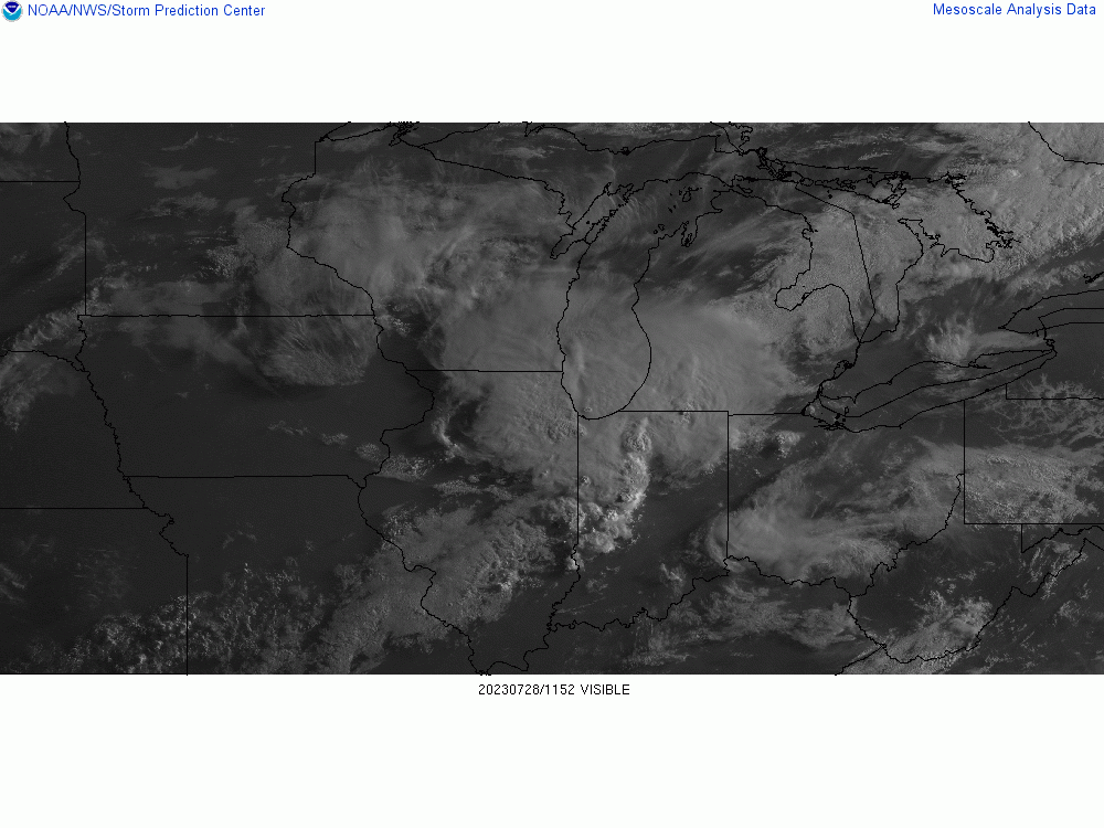
1 minute ago, frostfern said:
I get a severe warned shower with tops below 30k and no lightning. Skip. Just give me a real thunderstorm once this year.
Yeah, I kinda had a feeling this is how today would unfold.
I’d throw the towel in anywhere west of 127 and north of 96. Believe anything that develops to the west will be sub-severe and mainly follow the instability gradient to the south.
-
Had a 20mph gust-front here with some torrential rain. Minor flooding on side streets. Temps down to 66°. No lightning.
The atmosphere has over-turneth. -
33 minutes ago, outflow said:
I think the severe chances, besides some low end risk over the next 1-3 hrs, are highly in question just about anywhere in the enhanced risk area with this first mcs coming through before the better support and dynamics come into play later this afternoon. There will have to be a quick recovery in order for another round to fire and have a chance at some higher end potential.
At least there is another widespread rainfall to continue to erase drought concerns.
I agree. GRR is optimistic on this first round not overturning the atmosphere and better instability (even mentioning sunshine) later this afternoon setting the stage for severe.
I just don’t see that happening, and the 15z HRRR agrees. I could see more of an isolated threat but with that, most of the storms this afternoon would be independent sups capable of some tornados with the directional shear in place.Highly conditional, but would expect areas closer to Detroit, Toledo, Findley and areas into Canada - such as Chatham to really be under the gun later on today.
-
Thinking that the best shot for severe will be closer to Metro Detroit later on today. Lots of clouds and the decaying mcs is out running the better support over this way.
-
Every hour of the HRRR has been a significantly different outcome. Very fluid situation as CAMs are struggling with actual placement of storm development with every advancing hour.
I don’t think we’ll have much of an idea of what truly transpires until at least 06-12z tomorrow when upstream convection develops. At that point it’ll be easier to differentiate CAMs and other short range guidance into a solution more likely to transpire; hence the blob vs. a more detailed outline for tomorrows SVR WX outlook.
One thing for certain is the ingredients in place for tomorrow are better than average for this summer at least. Plenty of heat, higher surface dew points, potent shortwave approaching, deep layer around ~50kts, high lapse rates, etc… all depends on what develops overnight into tomorrow morning. Obviously a better chance if more instability is realized and less morning cloud cover materializes.
Finally, something to watch.
-
4
-
-
Missed out on rain/storms yesterday and unfortunately it doesn’t look like a chance in the foreseeable future.
But I’ll be damned if I don’t see a couple more backdoor cold fronts slipping through within the next 7-10 days. Unreal.

-
24 minutes ago, Spartman said:
Looks like a short stretch of Fall weather is in store starting tomorrow.
Yeah doesn’t look very summer like. Hoping we get some measurable rain at least.
-
1
-
-
Oh would ya just look at it?
No, not the smoke…
Nope, not the corn….But another lovely backdoor cold front plowing down from where? You guessed it… the Northeast on Wednesday. The blocking lives on!
-
 1
1
-
-
You know what I hate?
Backdoor cold fronts. First today of many to come in the next week.
-
 1
1
-
-
15 minutes ago, HillsdaleMIWeather said:
Tired of getting missed south and west lol
Our time will come. We got some good snows that they didn’t get so mother nature is sticking it to us at the moment.
-
12 minutes ago, Lightning said:
We are now entering the debris cloud season in SE MI.

I guess personally I would rather have debris clouds than a stacked upper level low sitting for a week.
-
1
-
-
2 hours ago, SolidIcewx said:
Absolutely a gorgeous day today! I’m glad we paid our dues for the omega block pattern. 0 complaints
Well don’t get too excited, this too shall pass. MJO is looking more likely that we to go back to cooler than normal with an eastern trough/western ridge around or after the 15th of the month and you guessed it, the blocking persists the rest of the month.
Hopefully we’re done with the freezing temps but I bet we get close.
-
1
-
1
-
-
Well it went from 40°s to 70°s.. the switch has been flipped.
-
Call me crazy but I bet we’ll be wishing for a day like this in about 20 or 30 days
-
1
-
1
-
-
9 minutes ago, Stebo said:
The blocking will weaken, all the teleconnections go toward favorable values and the MJO progresses out of the phase it is in now. The ensembles reflect this nicely.
Thanks for that Stebo. I’ve noticed the MJO looks favorable for a transition to possibly warmer than normal by week 2 of May. Hopefully we get a little more spring instead of 40’s and 50’s right to 80’s.
It’s about time, seems the blocking really tending to favor us in recent years. -
What? You mean to tell me the OP runs won’t verify 5-10 days out?
Ridiculous. Accuweather has the forecast for the next 2 months!
I’m just taming my optimism for the warm-up in the event that it gets shunted (thanks blocking).
-
2
-
-
Remember how the long range looked promising?
It doesn’t anymore. Two or three backdoor cold fronts from the Northeast with freezing temps through the middle of the month.
Sweet.
-
2
-
-
1 hour ago, luckyweather said:
~50 days until days start getting shorter
Man.. thanks for that. Kinda hurts.
Fun Fact: The sun angle is currently the same as early August.-
2
-
-
The persistence with the eastern trough though.
Kinda sad here. All the trees and shrubs went from bright green fluff to brown/yellow/red. Almost looks like fall around here. Everything would’ve been full bloom by now if the temps would’ve stayed somewhat decent (50°s/60°s) but the 20°s and 30°s really put a halt to their growth.
-
3
-
-
14 hours ago, Harry said:
Hopefully come May we can get some real consistent spring wx with temps in the 60s/70s.
At the beginning of last weeks “summer”, I told myself “we’ll be paying for this in a week”, well, here we are. Also last nights run of the GFS - no thanks, though it would be cool to see a foot a snow overnight in late April.

2023 Short/Medium Range Severe Weather Discussion
in Lakes/Ohio Valley
Posted
I don’t know, not throwing the towel in yet, but I fully expect temps to be overdone at minimum today.. thus keeping instability tamed. This crapvection is naturally going to inhibit some of what could’ve been this afternoons potential.
Also… that’s a ton of debris clouds - a good 6-8 hours worth moving ever so slowly east.