

Harry Perry
-
Posts
976 -
Joined
-
Last visited
Content Type
Profiles
Blogs
Forums
American Weather
Media Demo
Store
Gallery
Posts posted by Harry Perry
-
-
The HRRR was right last night, for the most part anyway. Looked like a hot mess for this morning and the hot mess transpired. I expected storms later on today so I took it upon myself to take advantage of the warm temps to epoxy paint my enclosed trailer floor thinking, “oh I have a few hours before the rain”… I’ll tell you all one thing, don’t.
At least don’t believe the radar when it looks like you’ll have an hour before the rain begins; because surprise! Sideways rain and 40mph wind 5 minutes later from a rogue cell the developed in one scan.
What. A. Mess. Epoxy everywhere, chips all over the yard. Standing water 3” deep in my backyard (where the trailer is currently parked).
Today, in all… a huge shit sandwich.
-
 5
5
-
-
20 minutes ago, HillsdaleMIWeather said:
Sun has actually came out here for the last 30 mins
You certainly stand a good chance for a good one this afternoon.
-
17 minutes ago, HillsdaleMIWeather said:
The cold front already being over the lake is wayyy ahead of schedule and is probably why the risk is a little less now
Yeah unfortunately this will be yet again another sando for Michigan. Best chances will be south and east.
-
 1
1
-
-
Got 10 seconds of sun this morning so I’m expecting an EF-4 by noon, but in all seriousness waking up to 70° feels like mid-summer here this morning.
Lots of crap-vection going on just to my west, have a feeling that’s going to set the stage for outflow boundaries later on however I think the best shot at severe or tornadoes specifically with discrete-sup’s will end up being Coldwater/Jackson/Lansing and east. I believe St. Joeseph/Calhoun county will be a little too close to the worked over atmosphere from this morning for anything major.
-
1
-
-
7 minutes ago, Torchageddon said:
When has the wf overperformed around these parts (ie pushed further north than expected)? I got nothing for that its always under. I was going to ask the same some time ago about slower fronts but this event sort of did that; bucked the trend. Sando?
Yeah the baroclinic zone usually sets up along I-80 more often than not, something to do with the cold lakes? I’d be interested to find reasoning on why.
Shit Sandwich = Sando
-
 1
1
-
-
12 minutes ago, HillsdaleMIWeather said:
The other 0Z models still have supercells before the front and are slower, the HRRR has been having a lot of issues today dealing with the warm front placement
Ahh makes sense. Wonder how far north the warm front will lift, underperforming to our west I read. Been busy and haven’t checked other guidance yet but good to know that HRRR is a sando tonight.
-
00z HRRR shows a line of scattered crap-vection moving through around 9-10am just prior to fropa. Looks like the front has sped back up and clears the area by 2pm. Doesn’t look like much of a threat on that particular model around here.
-
18 minutes ago, sbnwx85 said:
Done following snowstorms.

It’s all fun and games until we get into spring/summer and the baroclinic zone stays south of I-80 time and time again.
-
 1
1
-
1
-
-
3 hours ago, A-L-E-K said:
probanly for the best taking care of all weak limbs and trees before the great michigan derecho of 2023 hits later this summer
This year does have a 2011 feeling to it
-
2
-
 1
1
-
-
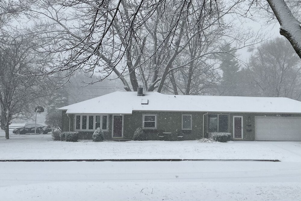
Really coming down here. Looking like we might be in the pivot zone, heavier totals may actually pan out. Already approaching an inch here.
-
3
-
-
5 minutes ago, Harry said:
Yep. Picking up. Light snow here.
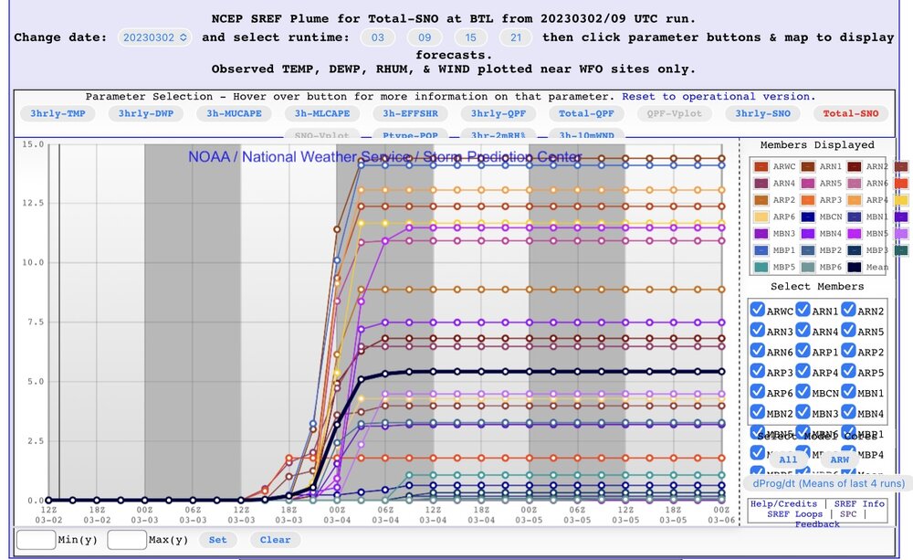
You see point and click now has a total of 13 here. With temps looking colder and below freezing I wonder if GRR ends up upgrading to blizzard warnings?
No I’ve been busy, just about to take a gander and the latest. 13”.. impressive. The 12z trends this morning had me thinking maybe this would end up further east. I do see there’s some 50-60mph gusts southwest of us.. makes me wonder if they would pull the trigger on blizzard warnings. This snow type isn’t usually very conducive of blowing and drifting, but with 45mph winds it would make up for the heavy water content in the snow, so it’s possible. They’ll probably keep things as-is being it’s a relatively short duration event.
-
Flurries just starting here.
-
1
-
-
Man… I’m starting to think we’re going to bust over this way. Every run, even the 06z Euro is bleeding east.
-
Man can you imagine if the RDPS verified?

-
1
-
-
3 minutes ago, Harry said:
Wish the model was correct with the temps which it shows them dropping to freezing the moment the precip arrives and then goes a bit below till the precip starts to wind down and the temps go back slightly above..
That would be nice.. also entirely possible with evaporative cooling/increasing wind. Will be fun to watch.
-
Harry I believe your snow magnet worked because it would appear the models have honed in on the jackpot zone being between my place and your place.
-
1
-
-
Just now, Harry said:
NAM looking like it has finally caved to the more southerly track.
Only took 96 hours

-
1
-
1
-
-
13 minutes ago, Harry said:
Like the NAM they remain defiant. It's killing them that the heaviest snows may go se of Grand Rapids. They are perhaps the most imby weenie office on planet Earth. Lol
So. True.
They have the “Since we here at the NWS GRR Office will not be receiving the brunt of the storm, we will go with an inch or less for the county entire area” attitude.
For this event they seem pretty optimistic about heaviest totals in a triangle from Lansing to Kzoo, to Jackson.
-
2
-
-
Love to see it
-
1
-
-
Yeah, this thing is going to blow its wad too quick and end up drying out fast as it shoots east.
What’s interesting is the pockets of heavier snow/QPF as shown on the 12z GFS. That tells me there’s gonna be a lot of convection in the warm sector that’ll probably rob moisture from the cold-side, hence the lower totals in areas where you wouldn’t expect it over central Missouri, north-central Illinois and especially in Michigan.-
1
-
-
My power finally went out at 11:30 last night. Picked my son up this morning and noticed several large diameter branches down. Power lines covering the road in a few spots with caution tape. Couple branches have fallen on cars and destroyed them on my block. Lots of branches that have also managed to go through the roof and into peoples living rooms. Nasty storm.
Also, lost a Paw Paw firefighter last night, he came in contact with a down powerline, and it was still live. Pretty sad.
-
8
-
-
Standing outside at the moment just listening to the crackling and crashing of tree branches in the distance. Power flashes look like lightning every few minutes. Several without power, half of my block is out but somehow managed at least for the time being to keep power at my place. Have approximately .50” of ice on everything. Tomorrow morning will make for some awesome pictures. Still raining here at 31°. Can’t imagine much more than maybe another .05” if that before this wraps up.
Jackson and Hillsdale got absolutely clobbered. Interested to hear what they ended up with total.
-
1
-
1
-
-
32° here. Sleet and freezing rain. About a quarter inch so far, waiting to see if the temp is going to drop a bit after dark. Heaviest rates still to come according the GRR. Definitely seems significantly worse east of here.
-
1
-
-
Just went outside and noticed the ice on the old lady’s car is now melting and sliding off, might get lucky over here.

Spring 2023 Banter Hangout
in Lakes/Ohio Valley
Posted
OnlyFans?