sussexcountyobs
-
Posts
1,977 -
Joined
-
Last visited
Content Type
Profiles
Blogs
Forums
American Weather
Media Demo
Store
Gallery
Everything posted by sussexcountyobs
-
Not liking these south trends at all on the models today.
- 2,426 replies
-
- 4
-

-
- heavy snow
- ice pellets
- (and 3 more)
-
So again all knowledgeable one. As of tonight, what's your forecast for this Sunday thru Tuesday?
- 2,426 replies
-
- 7
-
-
- heavy snow
- ice pellets
- (and 3 more)
-
I didn't say it was crazy, wrong, right, or a sound forecast at this point. I just stated what the guy said.
- 2,426 replies
-
- 1
-
-
- heavy snow
- ice pellets
- (and 3 more)
-
I was getting a coffee in Dunkin Donuts, and it was on their TV. LOL
- 2,426 replies
-
- 2
-
-

-
- heavy snow
- ice pellets
- (and 3 more)
-
FWIW Ijust saw Lee Goldberg on tv. He said theres possibility of a decent snow, but right now he's expecting just on and off snow and rain showers for Monday.
- 2,426 replies
-
- 3
-
-

-
- heavy snow
- ice pellets
- (and 3 more)
-
Light accumulating snow continues. 1" otg. Temp hovering between 27.5 and 27.7. Will not measure again till early tomorrow morning.
-
Steady light to occasionally moderate bursts of snow . 28° Plow just came by. Measured .9"
-
Snow has started to pick up a bit in last 10 minutes. We should reach an inch I would think. Lol
-
Approaching .8" here in Vernon @ elevation of 1217' with very light snow falling . Temp 27.5
-
Very light snow falling. 27.5 ° .7" otg
-
Yes. First and only measurement. Just got back home. Steady light snow falling now @ 28°
-
Just had a burst of moderate snow. Now just light snow. Measured. 6" 28°
-
Snow falling. 27.8
-
Thanks Walt. No. I do not have any model data except what you guys post here. I rely on you guys for that. So. Most likely the NWS forecast is what to be expected. Hopefully they bust low.
-
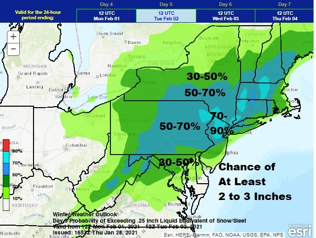
I don't understand why all these maps are showing my area 3-4" while my NWS forecast is saying only up to 1" of snow/sleet?
-
January 2021 General Discussions & Observations Thread
sussexcountyobs replied to Stormlover74's topic in New York City Metro
Is this a Monday, or Tuesday threat? I hear GFS is like a day faster with this threat. -
My WWA for Sussex county calling for up to 1" of snow and sleet. Then .1-.2 of freezing rain. Folks in and around the city shouldn't get their hopes up for more than that.
-
January 2021 General Discussions & Observations Thread
sussexcountyobs replied to Stormlover74's topic in New York City Metro
Is this for Monday/Tuesday next week? All my forecasts I read are showing it for Sunday/Monday -
Thanks.