sussexcountyobs
-
Posts
1,978 -
Joined
-
Last visited
Content Type
Profiles
Blogs
Forums
American Weather
Media Demo
Store
Gallery
Everything posted by sussexcountyobs
-
Mt. Holly .LONG TERM /SUNDAY THROUGH THURSDAY/... Low pressure will track through the Ohio Valley Sunday and it will transfer its energy to a coastal low Sunday night into Monday. The lows origin will be from the Pacific Ocean, and it will tap into moisture from the Gulf of Mexico as well as the Atlantic Ocean. With high pressure to the north, this provides a good setup for a winter storm to affect the area. Also, the coastal low will likely be slow to move once it does develop near the Delmarva and that is due to blocking high pressure to the north. Therefore, a prolonged period of wintry precipitation is possible for at least portions of the area. Exact details are still uncertain at this time, but it does appear that snow will overspread the area ahead of the primary low Sunday from southwest to northeast. Accumulating snow is likely for most areas during this time. Warmer air will begin to work its way in from the Atlantic Ocean, likely causing snow to mix with and even change to rain Sunday afternoon into Sunday night across the Delmarva into southern New Jersey. The rain/snow line will approach I-95 later Sunday night into Monday, which adds some uncertainty to the forecast in regards to how much accumulation there will be. Coastal low pressure will remain near the Delmarva Coast Monday through Monday night before slowly moving off to the east Tuesday. A prolonged period of wintry precipitation is likely to continue Monday and Monday night, especially near and north of Interstate 95. Rain or rain changing to snow is more likely farther south into southern Jersey and the Delmarva. Significant snow accumulations are possible, especially for areas where snow does not mix with or change to rain. Snow may continue Tuesday and Tuesday evening, but with the low slowly departing it does appear that precipitation rates will decrease. It seems like as of now, Mt. Holly does not see the low hugging the coast and moving north or northeast. But, east, from the Delmarva.
- 2,424 replies
-
- 1
-

-
- heavy snow
- ice pellets
- (and 3 more)
-
Not liking these south trends at all on the models today.
- 2,424 replies
-
- 4
-
-
- heavy snow
- ice pellets
- (and 3 more)
-
So again all knowledgeable one. As of tonight, what's your forecast for this Sunday thru Tuesday?
- 2,424 replies
-
- 7
-
-
- heavy snow
- ice pellets
- (and 3 more)
-
I didn't say it was crazy, wrong, right, or a sound forecast at this point. I just stated what the guy said.
- 2,424 replies
-
- 1
-
-
- heavy snow
- ice pellets
- (and 3 more)
-
I was getting a coffee in Dunkin Donuts, and it was on their TV. LOL
- 2,424 replies
-
- 2
-
-

-
- heavy snow
- ice pellets
- (and 3 more)
-
FWIW Ijust saw Lee Goldberg on tv. He said theres possibility of a decent snow, but right now he's expecting just on and off snow and rain showers for Monday.
- 2,424 replies
-
- 3
-
-

-
- heavy snow
- ice pellets
- (and 3 more)
-
Light accumulating snow continues. 1" otg. Temp hovering between 27.5 and 27.7. Will not measure again till early tomorrow morning.
-
Steady light to occasionally moderate bursts of snow . 28° Plow just came by. Measured .9"
-
Snow has started to pick up a bit in last 10 minutes. We should reach an inch I would think. Lol
-
Approaching .8" here in Vernon @ elevation of 1217' with very light snow falling . Temp 27.5
-
Very light snow falling. 27.5 ° .7" otg
-
Yes. First and only measurement. Just got back home. Steady light snow falling now @ 28°
-
Just had a burst of moderate snow. Now just light snow. Measured. 6" 28°
-
Snow falling. 27.8
-
Thanks Walt. No. I do not have any model data except what you guys post here. I rely on you guys for that. So. Most likely the NWS forecast is what to be expected. Hopefully they bust low.
-
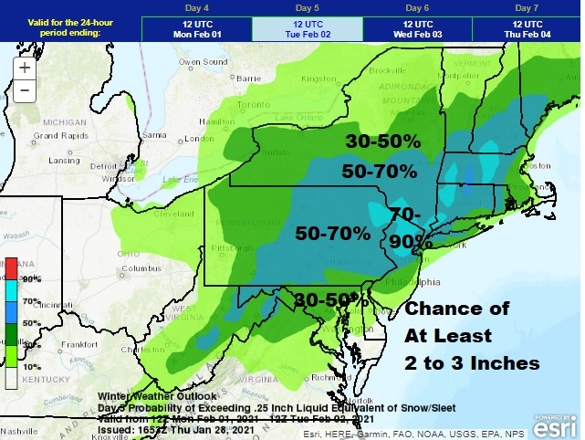
I don't understand why all these maps are showing my area 3-4" while my NWS forecast is saying only up to 1" of snow/sleet?
-
January 2021 General Discussions & Observations Thread
sussexcountyobs replied to Stormlover74's topic in New York City Metro
Is this a Monday, or Tuesday threat? I hear GFS is like a day faster with this threat. -
My WWA for Sussex county calling for up to 1" of snow and sleet. Then .1-.2 of freezing rain. Folks in and around the city shouldn't get their hopes up for more than that.
-
January 2021 General Discussions & Observations Thread
sussexcountyobs replied to Stormlover74's topic in New York City Metro
Is this for Monday/Tuesday next week? All my forecasts I read are showing it for Sunday/Monday