GaWx
Members-
Posts
18,598 -
Joined
Content Type
Profiles
Blogs
Forums
American Weather
Media Demo
Store
Gallery
Everything posted by GaWx
-
Alan Huffman’s call:
-
Icon last 4 runs looking better for S GA to WC SC:
-
Thanks, Brick. Even that’s probably overdone in much of the blue area (1”+) due to marginal temps. But that blue area on your 12Z map an hour or so to my west is my tentative target for a Sun PM drive.
-
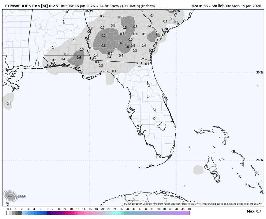
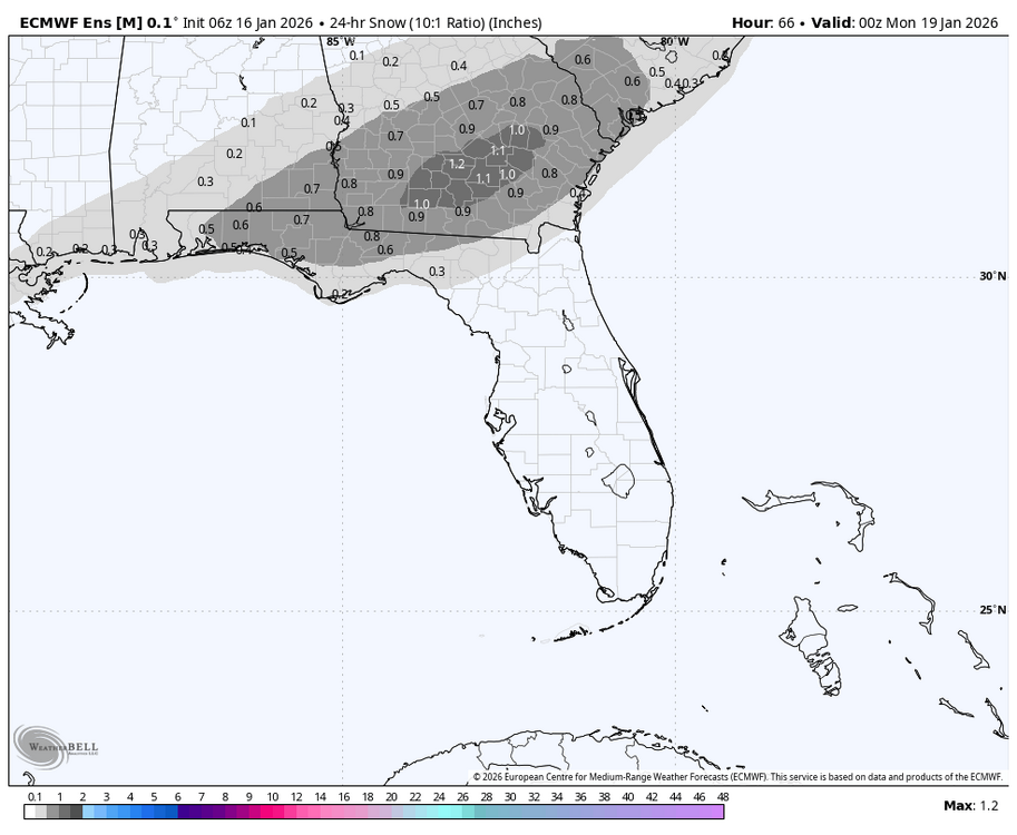
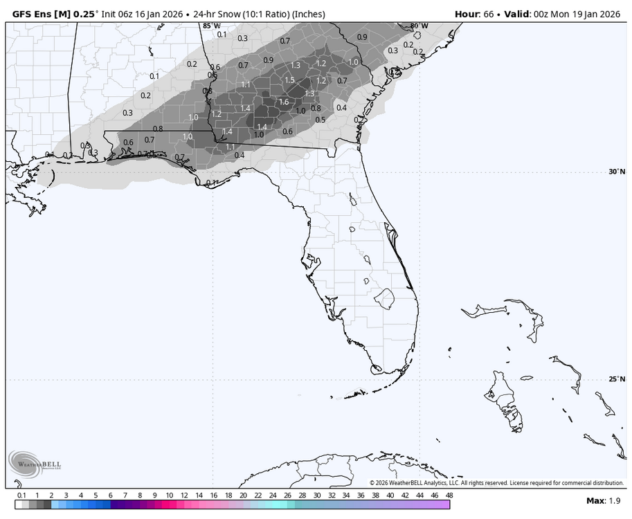
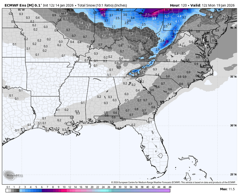
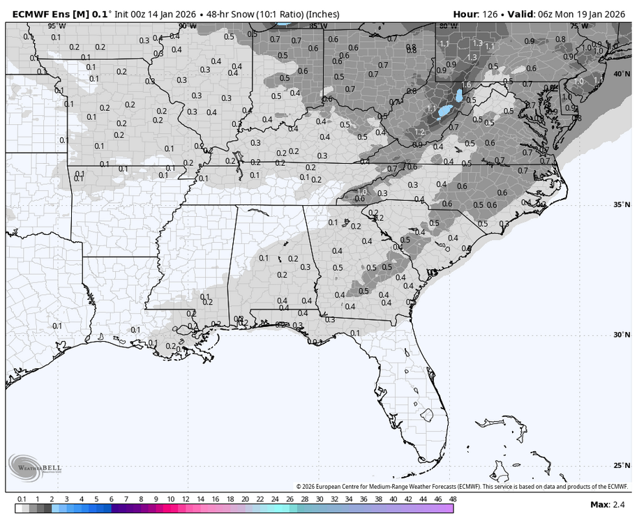
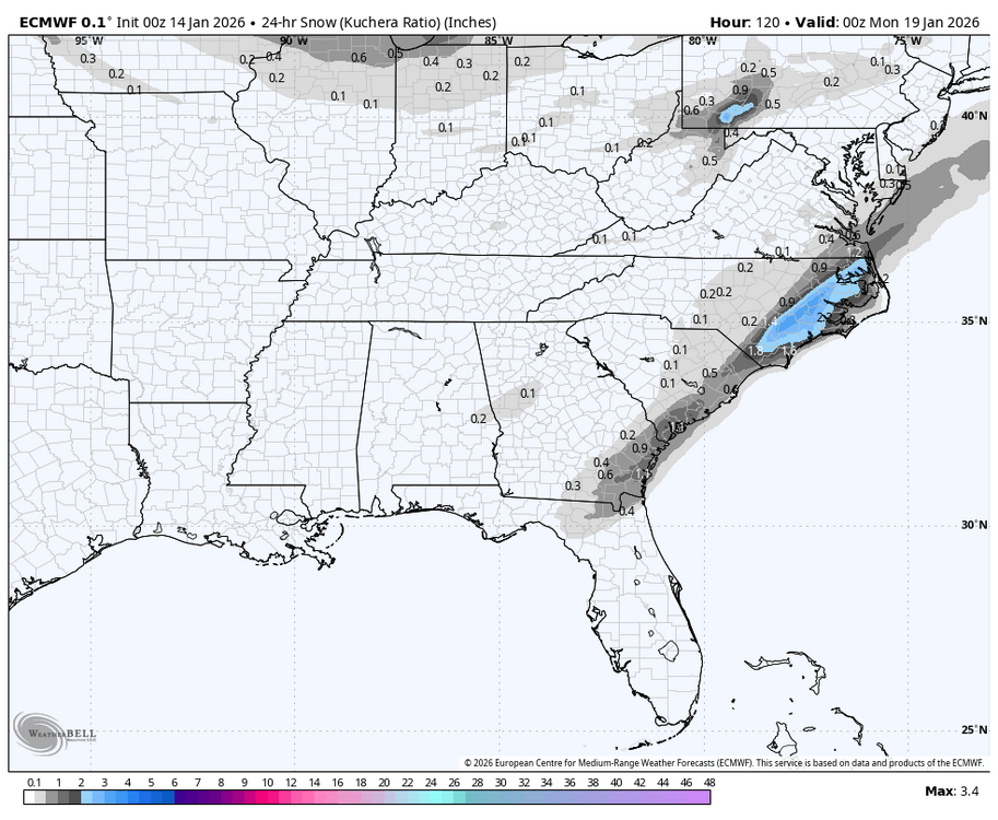
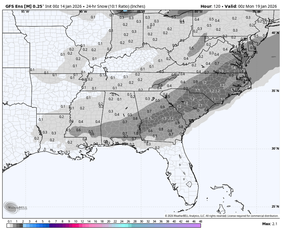
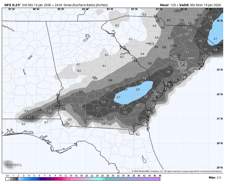
Very rare S GA snow: will it happen? This potential is exciting, but accumulations are probably overdone. I’ll be considering driving to it if it’s within a 1-1.5 hours drive out I-16 assuming the roads are not too affected, which is my guess due to marginal 2m temps. Right here, I’m hoping for a few flurries mixed in with the rain, but there could easily not be any snow mixing in as it doesn’t look quite cold enough right now though I’ll keep monitoring for model changes: 6Z 1/16 EPS: 6Z 1/16 GEFS: 6Z 1/16 Euro AI ens is more realistic imho with lower accums (<1”) but even that would be a rare event:
-
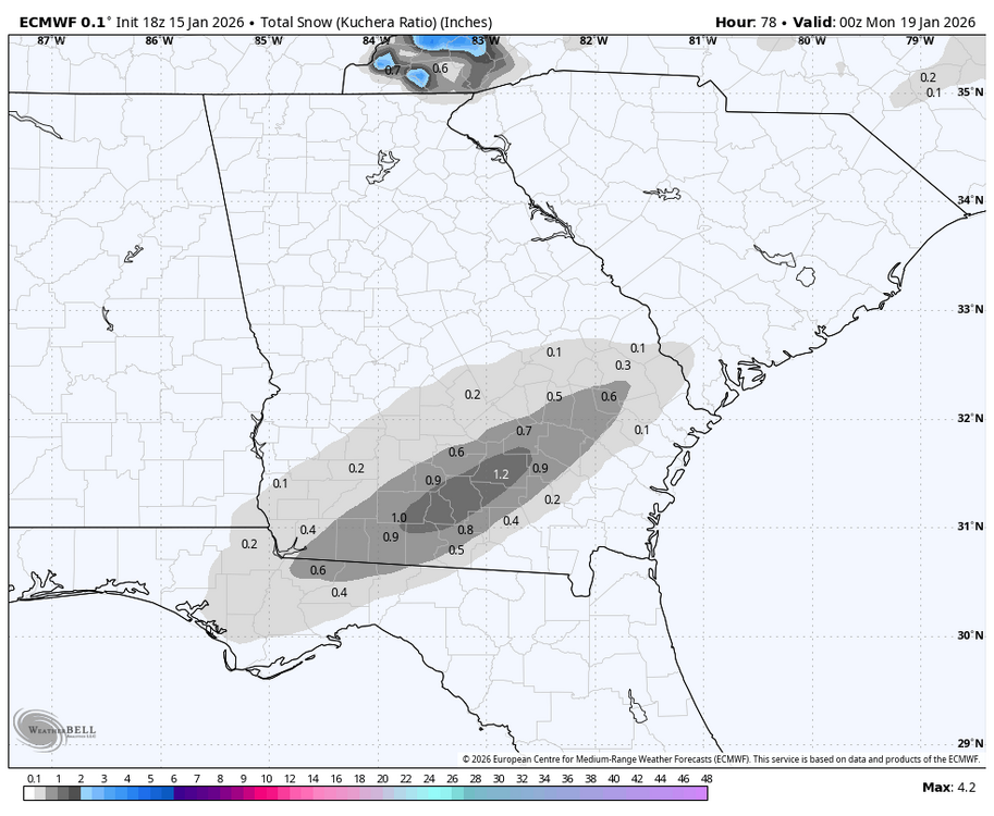
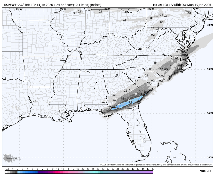
18Z Euro would be a dream come true for some S GA snow lovers with a max of 1.2” at Douglas (see below). I’m not betting on that much accumulating there but we’ll see. How often has Douglas received 1.2”+? Not very at all as the ~120 year wx history shows only 5 times meaning a 1.2” snowfall there would be ~1 in 25 year occurrence. However, all five have been since 1973 meaning that would be a ~1 in 10 year occurrence over the last 52 years: 2/10/1973: 3.0” 12/22-23/1989: 3.3” 2/13/2010: 1.5” 1/3/2018: ~3” 1/21-2/2025: 4.5”
-
Very interesting. Recon is going to be flown out tomorrow afternoon and late tomorrow night to collect extra data to be fed into models probably due to the large disagreement between the King and others: this would affect the 0Z and 12Z runs of 1/17:
-
It was great luck for the Gulf coast, S GA, and the E Carolinas! I owe getting my record sleetstorm to Sir Brick.
-
It doesn’t look to me like it was due to a skew from amped members. This was a typical notable shift NW in the avg track.
-
This is due to a significant shift NW of the GEFS mean from 12Z to 18Z. More shifts later are most likely as of current thinking.
-
Thanks for your thoughts on this. For comparison, @eyewall started the 1/10-11/25 thread 4 days out and @Brick Tamlandstarted the 1/21-2/25 thread 3 days out. So, starting it tomorrow would match Brick’s timing for 1/21-2.
-
Imho, it’s getting close to a good time for someone to start a 1/18/26 storm threat thread. Other opinions? 12Z EPS mean looks very nice for many though of course many others won’t like as is almost always the case; regardless this shows there’s plenty of spread still: 12Z EPS members:
-
The 12Z Euro was good for the E Carolinas and extra good from part of SE GA into the E FL panhandle. Of course I’d love for it to verify similarly in this area, but I’m still leaning to the 1/28-9/14 type of NW model trend like the 12Z GFS did due to similar indices to take most or all of it away. We’ll see as every case is somewhat unique:
-
If this were to verify with hardly any -PNA upcoming, that would increase the chance vs earlier runs that Jan will end up net +PNA just like all -ENSO Decs since 1983-4 have transitioned to in Jan.
-
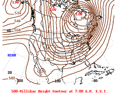
I remember 1/28/14 originally per models out ~5 days looking to nail coastal areas like mine with a wintry mess and then doing the typical trending NW and reducing coastal area wintry precip. to a lot lower than models had had to a minor event here. Comparisons of indices for 1/28-9/2014 to progged 1/18/26: Index…2014….2026 MJO…...6……….….6 PNA….weak +….mod/strong + EPO….strong -….very strong - WPO…neutral……….- NAO….weak +…neutral to weak + AO…..strong -…..mod - So, for those of you who want the NW trend to continue and end up similarly to 2014 (not me obviously), the indices line up pretty similarly to 1/28-9/2014 unfortunately for us deep SE folks and fortunately for ATL-RDU and further NW. The main differences though this time are a stronger +PNA and -EPO (i.e., more impressive W NA ridge) and a -WPO vs neutral then. I don’t know whether or not that would change things much vs the 2014 trend. Now I’ll show how much stronger the W ridge/E trough couplet is this time vs 2014: 1/28/14 12Z H5 had 564 Washington/Canadian border and 559 Atlanta: 1/18/26 12Z H5 prog 576 Wash/Can border and 546 Atlanta meaning a much more impressive and sharper W ridge/E couplet this time:
-
0Z Euro is sticking with the coastal regions of SE for heaviest but extends to RDU: 0Z EPS mean has sig. increase: RDU near the max with 0.6”: I count 18 with something in my area (largest I counted before was 13 on 12Z) and ~25 in RDU out of 50:
-
Actually, with the typical NW trend, which is in reality an unwinding of too far SE biases, you’re very much in this one. I think due to this and backed by climo, you have a better chance than us peeps way down in the Deep South of getting some of this. One never knows since every case is different, which makes forecasting discussions so interesting. Why is it so quiet in here? It’s not quiet at the other place. I guess most everyone here is sleeping? Or is almost everyone over there?
-
-
The 0Z GFS is giving >1” of snow to this area on Jan 18th, which would be the second straight Jan with measurable snow. That’s never happened since official records started 150 years ago. The closest thing to that would be Jan of 1921’s 0.5” and Jan of 1922’s major icestorm. And then the glorious Jan of 1977 had two. Climo always says bet against measurable wintry precip here as no more than 25% of winters have had that. OTOH, there has been increased ensemble support. But OTOH, there’s the typical NW trend when there’s no -NAO, which would work against it. So, keeping all of that in mind, I’m taking this with a grain (2m temps are also progged to be marginal as of now with 34-35 being the coldest):
-
I don’t think I can because I don’t have a list of La Niña by location. If you can provide that, I can break it down.
-
I didn’t break it down by La Niña location.
-
Actually, I did a study recently that surprisingly showed that Jan phase 6 in the SE (using GSP as a representative) has had a mix with a bit more cold vs warm phase 6 Jan periods. Examples of cold during La Niña in Jan: 1975 (8 BN), 1976 (9 BN during a long period of 13 days), 2000 (4 BN), 2011 (7 BN during a long period of 12 days), 2022 (9 BN), and 2025 (5 BN). There were some mild Jan phase 6 periods during La Niña also like 1989 (+8) and 2008 (+8) although those two were only 3 days long each. Keep in mind though that the current phase 6 started off mild. So, it remains to be seen how cold it will end up overall as it’s progged to last through ~Jan 21st.
-
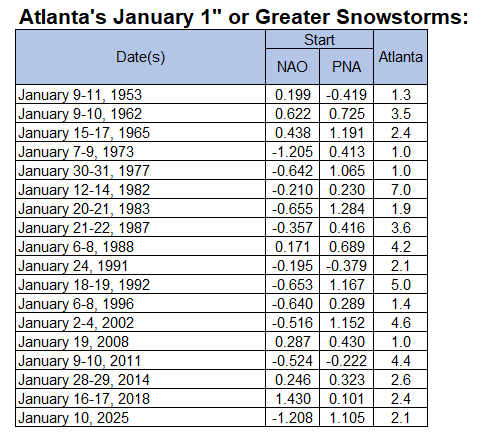
From Don Sutherland: Yes, the PNA is far more important to Atlanta's January snowstorms than the NAO. Since 1950, the PNA was positive for 84.2% of Atlanta's 1" or greater snowstorms. The NAO was negative for 63.2% of such storms. I’ll add that that these Jan snowstorms were during La Niña: Dates……PNA…….NAO 1/15-17/1965…+1.191…+0.438 1/6-8/1996…+0.289…-0.640 1/19/2008…+0.430…+0.287 1/9-10/2011…-0.223…-0.524 1/16-17/2018…+0.101…+1.430 1/10/2025…+1.105…-1.208 So, just for the six 1”+ Jan storms during La Nina: -5 of the 6 PNAs were >0 and the lowest was only down to -0.223. Avg PNA was +0.5 -In contrast, 3 of the 6 NAOs were positive with one of them strongly positive. The avg NAO was near 0/neutral. ————— The 1/18/26 potential SE snowstorm looks like it will be during a moderate MJO phase 6, a strong +PNA, a neutral to moderately -AO, slightly + to neutral NAO, -WPO, and a very strong -EPO, which may be sub -3 then. So, the highlight is strong +PNA/-EPO during a phase 6.
-
Look how much this changed in just 2 days of runs:
-
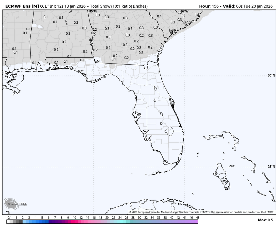
The 12Z EPS for SAV has gotten my attention for the small chance of Sun AM light snow/flurries, which in this area would be a big deal due to the relative rarity being that most winters get nothing, not even a T. We got nothing Feb 2018 through Dec 2024. My expectations, especially for measurable, are low due to climo, it being pretty dry overall with member qpf progs being light, and marginal temps. So, fwiw, here are some 12Z EPS images: ~25% of members have snow, which is notably high: Mean: 0.2”, notable for here:
-
Anthony, You just had a snowy December with two significant snowstorms and a colder than normal month. How is that the least bit boring?


