

GaWx
-
Posts
11,476 -
Joined
Content Type
Profiles
Blogs
Forums
American Weather
Media Demo
Store
Gallery
Posts posted by GaWx
-
-
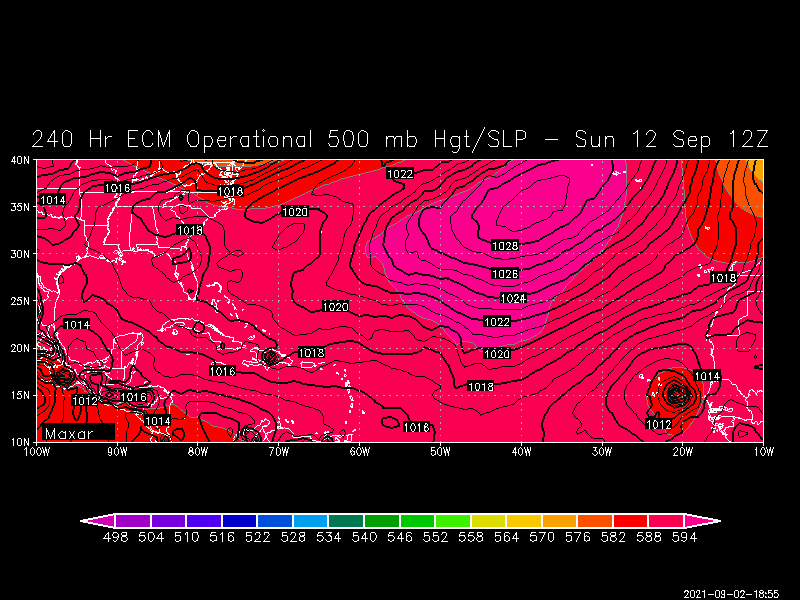
12Z Euro, like the 0Z Euro, has a TS just off the coast of Africa 9/11. This is consistent with the EPS runs I’ve been posting. Note how strong the central Atlantic high is to the NNW of it. If that were to verify, this likely wouldn’t recurve early and may even soon after this start moving WSW for a period, which would be a warning signal as Yaakov ( @jconsor) and I have noted, especially with the La Nina(ish) ENSO:
-
 2
2
-
-
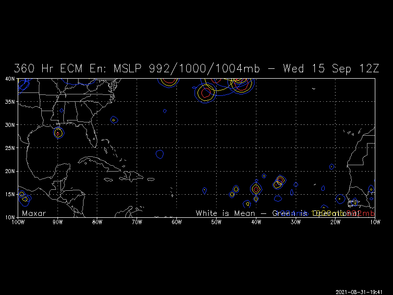
12Z UKMET: down to 922 mb at the end! But again, very low US threat. Bermuda needs to watch closely.
HURRICANE LARRY ANALYSED POSITION : 13.3N 33.3W
ATCF IDENTIFIER : AL122021 LEAD CENTRAL MAXIMUM WIND VERIFYING TIME TIME POSITION PRESSURE (MB) SPEED (KNOTS) -------------- ---- -------- ------------- -------------
1200UTC 02.09.2021 0 13.3N 33.3W 993 48
0000UTC 03.09.2021 12 13.8N 37.2W 988 50
1200UTC 03.09.2021 24 14.4N 40.5W 983 52
0000UTC 04.09.2021 36 15.3N 43.6W 977 62
1200UTC 04.09.2021 48 16.3N 46.2W 975 65
0000UTC 05.09.2021 60 17.6N 48.3W 971 65
1200UTC 05.09.2021 72 19.2N 50.6W 969 68
0000UTC 06.09.2021 84 20.9N 52.5W 960 77
1200UTC 06.09.2021 96 22.2N 54.4W 949 81
0000UTC 07.09.2021 108 23.6N 56.1W 941 97
1200UTC 07.09.2021 120 25.0N 57.8W 930 106
0000UTC 08.09.2021 132 27.3N 59.1W 922 107
1200UTC 08.09.2021 144 29.9N 60.0W 922 111
-
1 hour ago, Eduardo said:
Has Larry moved south of due west?
Larry has not moved S of due W between any two reference points. It moved due west between 8 AM and 2 PM yesterday and otherwise N of due W to WNW.
-
20 hours ago, GaWx said:
Following up from yesterday: today's 12Z EPS has similar activity and may be the next AEW to watch closely in the CONUS for after 9/20:
Still watching this timeframe as the 0Z EPS still has something coming off Africa ~9/11:
End of the run:
-
1
-
-
0Z UKMET: down to 927 mb at the end pf the run!
TROPICAL STORM LARRY
ANALYSED POSITION : 12.5N 29.8W
ATCF IDENTIFIER : AL122021 LEAD CENTRAL MAXIMUM WIND VERIFYING TIME TIME POSITION PRESSURE (MB) SPEED (KNOTS) -------------- ---- -------- ------------- -------------
0000UTC 02.09.2021 0 12.5N 29.8W 1002 41
1200UTC 02.09.2021 12 13.0N 34.0W 996 45
0000UTC 03.09.2021 24 13.6N 37.5W 993 44
1200UTC 03.09.2021 36 14.2N 41.0W 989 49
0000UTC 04.09.2021 48 15.3N 44.1W 981 54
1200UTC 04.09.2021 60 16.7N 47.0W 974 65
0000UTC 05.09.2021 72 18.1N 49.5W 971 62
1200UTC 05.09.2021 84 19.8N 51.8W 972 64
0000UTC 06.09.2021 96 21.4N 53.5W 969 67
1200UTC 06.09.2021 108 22.8N 55.1W 965 64
0000UTC 07.09.2021 120 24.0N 56.5W 952 81
1200UTC 07.09.2021 132 25.3N 57.9W 939 101
0000UTC 08.09.2021 144 26.8N 58.5W 927 105
-
3 hours ago, jconsor said:
Great stuff. Actually, I happened to have studied eastern Atlantic WSW movers, myself, a while back and saved this list of the 12 that made US landfall (all but Carol of 1953 hit as a hurricane)(# in parentheses is days from African coast to US landfall):
- #6 of 1893 (GA/SC) (14)
- #4 of 1928 (FL)(11)
- #4 of 1947 (FL, LA) (14)
- Able of 1952 (SC) (13)
- Carol of 1953 (ME grazed) (11)
- Donna of 1960 (FL, NC, New England) (12)
- Dora of 1964 (FL) (13)
- Allen of 1980 (TX) (12)
- Hugo of 1989 (SC) (12)
- Fran of 1996 (NC) (14)
- Isabel of 2003 (NC) (15)
- Ivan of 2004 (AL/FL) (16)
-
3
-
-
23 hours ago, GaWx said:
I'm still not concerned about Larry to be, but am somewhat more interested in what may happen a bit afterward. Way out in cartoonland, the 12Z EPS has an AEW that moves off Africa ~9/11 with many members remaining pretty weak but more importantly moving briskly westward. This may be a sign that it would move much further west than Larry. With it being La Nina or close to it, the climo of AEW's like this one says they have a better chance to get into the western basin than for other ENSO. That climo also says that AEWs that come off Africa through mid Sept., especially during La Nina, still often get pretty far west. Even so, it wouldn't be til 9/21+ that it could reach the CONUS based on this 9/15 map:
Following up from yesterday: today's 12Z EPS has similar activity and may be the next AEW to watch closely in the CONUS for after 9/20:
-
I'm still not concerned about Larry to be, but am somewhat more interested in what may happen a bit afterward. Way out in cartoonland, the 12Z EPS has an AEW that moves off Africa ~9/11 with many members remaining pretty weak but more importantly moving briskly westward. This may be a sign that it would move much further west than Larry. With it being La Nina or close to it, the climo of AEW's like this one says they have a better chance to get into the western basin than for other ENSO. That climo also says that AEWs that come off Africa through mid Sept., especially during La Nina, still often get pretty far west. Even so, it wouldn't be til 9/21+ that it could reach the CONUS based on this 9/15 map:
-
4
-
-
-
Wow, the 3.4 Nino weekly anomaly released today for last week warmed a whopping 0.6 C from -0.9 to -0.3! Whereas I’m sticking with my moderate La Niña call, that much warming was quite the surprise for me and doesn’t exactly help my confidence. We’ll see what the next few weeks bring.
Looking at records, an anomaly warming of 0.6+ in one week is rare though oddly enough 4 of the 5 occurrences over the last 31 years happened within just the last 2 years:
8/25/21 warmed 0.6
6/24/20 warmed 0.6
9/25/19 warmed 0.7
11/21/18 warmed 0.6
7/8/92 warmed 0.6
That's it for warmings of 0.6+ back to 1990!
-
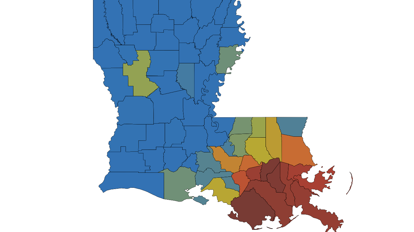
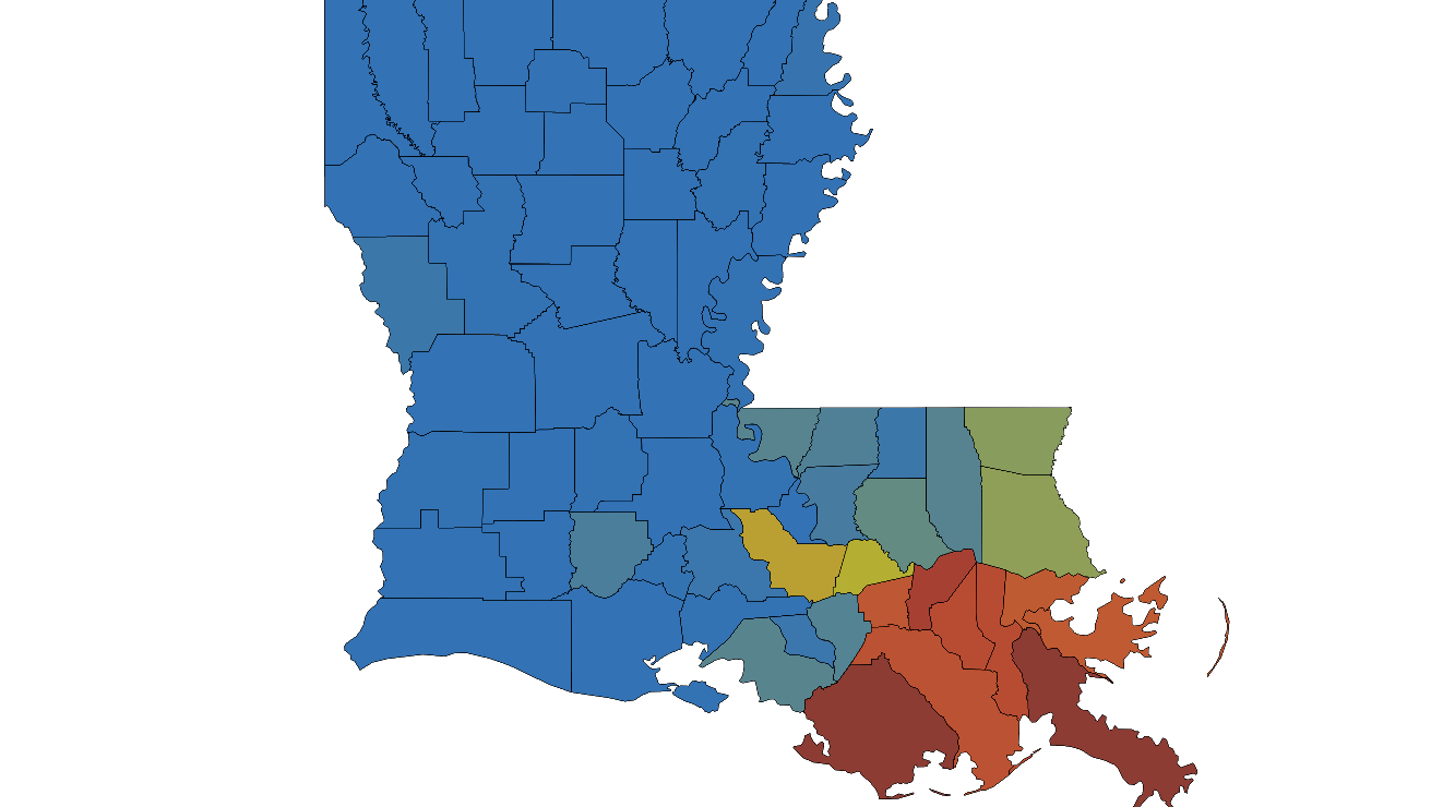
N.O. and vicinity now has over 90% of customers without power:
-
Going rapidly downhill at N.O. (Ignore the 32 dewpoints).
Intl Airport dropped 5 mb in the last hour and has 1/4 mile vis. There now is a whopping ~9 mb difference between there and Lakefront!
N.O. INTL ARPT HVY RAIN 77 32 19 E56G83 29.01F VSB 1/4
N.O. DWNTWN HE RAIN 78 76 93 MISG N/A VSB 1
N.O. LAKEFRONT HVY RAIN 77 32 19 E46G71 29.27F VSB 1/2
-
Latest LA outage map shows ~2/3 of N.O. area out of power:
-
 1
1
-
-
It continues to go downhill in New Orleans and the pressure gradient is now up to 6 mb over just a 15 mile distance!
5 PM CDT:
N.O. INTL ARPT HVY RAIN 76 75 97 E48G74 29.16F VSB 1/2
N.O. DWNTWN HE HVY RAIN 77 75 93 E23G46 29.27F VSB 3/4
N.O. LAKEFRONT HVY RAIN 77 76 96 E54G78 29.34F VSB 1/2
-
5
-
-
The latest wobble due north is bad news for the New Orleans area, especially for Kenner and even Metairie. Keeping in mind how bad it got in 1965 with Betsy (which was about 12 mb weaker at landfall and on a similar path) and with Ida still holding quite strong, this isn't going to be pretty for that area.
-
7
-
1
-
-
So, there's now a 3.3 mb gradient in N.O. over the less than 15 miles from the international airport, which is closer to the projected path, to the lakefront station.
-
1
-
-
3 PM CDT N.O. stations show a continued increase in winds and rapid drop in pressure along with a continued very strong gradient reflected by the 0.10" difference between the airport and lakefront:
CITY SKY/WX TMP DP RH WIND PRES REMARKS
N.O. INTL ARPT RAIN 77 74 90 E46G67 29.37F FOG
N.O. DWNTWN HE RAIN 77 74 90 E24G40 29.41F FOG
N.O. LAKEFRONT HVY RAIN 77 75 93 E51G72 29.47F VSB 1/4 -
LA power outages are now 85-90% in darkest colored counties and already almost 50% N.O. area:

-
2
-
-
2PM CDT N.O. stations: rapid pressure falls continue and winds increasing at Lakefront. Also, note how tight the pressure gradient is based on the 3 mb/.09” difference between the airport and lakefront:
CITY SKY/WX TMP DP RH WIND PRES REMARKS N.O. INTL ARPT RAIN 78 74 87 E36G59 29.43F FOG N.O. DWNTWN HE RAIN 78 74 87 NE12G35 29.47F FOG N.O. LAKEFRONT LGT RAIN 78 75 90 E53G66 29.52F FOG
-
These are the noon CDT conditions in N.O. showing gusts already to 61 mph. These will likely get much worse there during the next few hours. For a comparison, Betsy, which hit N.O. very hard, was 12 mb higher at 942 at about the time of landfall to the south vs the 930 of Ida in about the same location on a similar trajectory:
1200 PM CDT SUN AUG 29 2021
CITY SKY/WX TMP DP RH WIND PRES REMARKS
N.O. INTL ARPT LGT RAIN 80 74 81 NE32G61 29.58F
N.O. DWNTWN HE LGT RAIN 79 74 84 NE10G26 29.60F
N.O. LAKEFRONT LGT RAIN 81 75 82 E44G61 29.64F -
1 minute ago, jojo762 said:
What could very well be the last past through the true center from recon yields a 930.8mb extrap pressure.
That 930.8 mb makes Ida about 11 mb stronger than the 942 mb of Betsy of 1965 in about the same location on a similar trajectory.
-
2
-
-
0Z UKMET: LA vs 12Z at TX
NEW TROPICAL CYCLONE FORECAST TO DEVELOP AFTER 60 HOURS FORECAST POSITION AT T+ 60 : 23.2N 86.0W LEAD CENTRAL MAXIMUM WIND VERIFYING TIME TIME POSITION PRESSURE (MB) SPEED (KNOTS) -------------- ---- -------- ------------- ------------- 1200UTC 28.08.2021 60 23.2N 86.0W 1007 31 0000UTC 29.08.2021 72 25.0N 87.9W 1003 36 1200UTC 29.08.2021 84 26.7N 89.8W 999 39 0000UTC 30.08.2021 96 28.2N 91.2W 990 49 1200UTC 30.08.2021 108 29.5N 91.9W 978 60 0000UTC 31.08.2021 120 30.8N 92.1W 981 39 1200UTC 31.08.2021 132 32.5N 92.1W 983 30 0000UTC 01.09.2021 144 33.3N 91.7W 990 25 -
On 8/24/2021 at 12:06 PM, 40/70 Benchmark said:
Well, given that the ECMWF peaks at -.52C and the consensus of all guidance is -.55C, that makes sense.
Still argues weak. I would advise caution with respect to persistence forecasting, as it works until it doesn't...case en point the NAO this past winter.
I dug more into how far each average August model projection for fall/winter trimonthly peak missed for 2012-2020:
Year: Forecast/Actual/Miss
2020: -0.6/-1.3/+0.7
2019: +0.4/+0.5/-0.1
2018: +0.9/+0.9/0.0
2017: 0.0/-1.0/+1.0
2016: -0.6/-0.7/+0.1
2015: +2.3/+2.6/-0.3
2014: +0.7/+0.7/ 0.0
2013: +0.9/-0.4/+1.3
2012: +0.9/-0.4/+1.3
2012-20 avg miss: +0.4
2021: -0.6/????/????
Note that the average miss of +0.4 doesn't tell the whole story as there are two distinct groups:
- big positive misses: average of +1.1 from +0.7, +1.0, +1.3 +1.3 (2020, 2017, 2013, 2012)
- small misses: average miss of -0.1 from -0.1, 0.0, +0.1, -0.3, 0.0 (2019, 2018, 2016, 2015, 2014)
So, if 2021 ends up in the big positive miss group, the actual trimonthly peak would easily end up at least well into moderate La Nina range.
But if it were to end up in the second group, the actual trimonthly peak would end up either as either weak La Nina or high end cold neutral.
For reasons given earlier (mainly current weekly Nino 3.4 SST anomaly but with some backing by the July SOI and the OHC), I'm predicting that the fall/winter trimonthly Nino 3.4 peak will be within moderate La Nina (-1.0 to -1.4). That means I'm expecting 2021 to end up closer to the 1st group (big positive miss for August model average prediction) than the 2nd group.
By the way. I'm expecting a general increase in the SOI over the next week or so. Thus the August to date average should rise. Currently August MTD is only ~+1.5. However, August as a whole should rise to over +3 and may even rise to over +4. Then we'll see whether or not Sept turns out to be a more strongly positive month more like July's +16.
-----------------------------------------------------------------------
Source of August ENSO model prediction data 2012-20:
Source of ONI data:
https://origin.cpc.ncep.noaa.gov/products/analysis_monitoring/ensostuff/ONI_v5.php
-
1
-
-
9 hours ago, 40/70 Benchmark said:
That is mainly in the eastern zones, where we want it.
I'm still not sold on moderate.
I’m going moderate La Niña trimonthly peak at some point this fall/winter most likely followed by weak La Niña and then strong La Niña. Keep in mind that the August ENSO models have had on average a 0.25 C warm bias in Nino 3.4 through the fall/winter based on data from 2012-2020. Just last August, the model average for last fall and winter was for merely a borderline weak La Niña and yet it ended up with a solidly moderate trimonthly peak of -1.3 C. The models were similarly off with the prior La Niña in 2017. The last time the models were too cool in 3.4 was in 2016 when that La Niña warmed back to cold neutral more quickly than the model average predicted.


Major Hurricane Larry
in Tropical Headquarters
Posted
12Z EPS has many more members vs prior runs hitting or grazing E New England or Canada vs the 0Z: