

GaWx
-
Posts
18,239 -
Joined
Content Type
Profiles
Blogs
Forums
American Weather
Media Demo
Store
Gallery
Everything posted by GaWx
-
Good eye! Consistent with the further south operational Euro, the 18Z Euro ensemble mean’s axis of heaviest snow to the west at 144 came in ~50 miles south of the 12Z’s 150: It’s going to be tough to get the mean low track back southeast enough for a place like Atlanta to get at least several inches of snow but we’re still just far enough out that it’s still very doable even if not likely.
-
E US cold bias of most models strikes again. Hoping they won’t warm even further the next few days.
-
18Z GEFS: significant increase many areas, especially N GA (keep in mind this excludes ZR and any sleet Tony and others might get):
-
-
Good snow (couple of inches upstate SC to W NC)
-
Still wintry precip though
-
18Z GFS not looking encouraging sorry to say based on 135. Tracking too far NW for great setup. let’s see how much wintry there is.
-
18Z Icon 120 is ~100 miles S of 12Z 126. Things like this can end up making a big difference down the road.
-
For ATL (city itself) as depicted it is closer to mainly sleet or rain with 850s of +1C: Surface 34F, so not ZR as depicted: qpf: AI continues with its unusual warm sfc wind flow..here it’s from SE, which disagrees with just about all other models (maybe it being AI is a handicap) and thus I think it won’t verify this way: Sfc: doesn’t look right. By the way, ATL has no major winter storm on record with mainly SE winds.
-
ATL had 4.2” of nearly pure sleet on both 2/17-18/79 and 1/7/88.
-
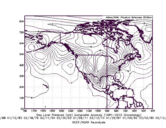
There are exceptions (like 3/1/09 which was mainly from a bowling ball upper low and 3/93) and variations but I’ll normally want a weak Gulf low passing ~ENE offshore the N Gulf coast and then going over the general vicinity of the north-central FL peninsula out into the Atlantic for the best shot at a major snow or sleet ATL-AHN corridor among other areas per history. Of course there has to be cold enough air to the north. Sometimes it can go from the Gulf to over FL panhandle to SE GA and work if the air is cold enough. The following map is the mean SLP map for winter storms that includes 2/12/14, 1/9/11, 2/12/10, 1/2/02, 1/18/92, 1/7/88, 1/22/87, 3/24/83, 1/12/82, 3/2/80, 2/18/79, 1/9/62, 3/11/60, and 2/26/52:
-
12Z EPS
-
12Z EPS: similar to 0Z EPS/12Z GEFS
-
12Z Euro has some ZR: snow:
-
12Z Euro low track way too far NW for big SE snowstorm. Need further SE track than GFS like on 7 of 30 GEFS members
-
12Z GEFS: members 5, 7, 8, 10, 13, 22, 27 (7 of 30) have a further SE tracking low than GFS: 5-8, 10, 22, 25, 27 have notable snow outside mtns, with 6 of these 8 having a further SE low track than GFS (your best bet): Mean snow through 1/11:
-
Much of this in SE AL/SW GA is ZR with IP to the north below the snow with cold rain SC/SE GA and much of SC:
-
12Z Icon:
-
0Z EPS: slight increase some, decrease others:
-
ATL gets much of its qpf in ZR/IP due to 850s of +2 to +3 and thicknesses near 552:
-
Major changes on 0Z Euro! SW upper low gets ejected much earlier.
-
Easily the best GEFS run in awhile:
-
The 546 thickness line is often near the snow line in the SE. That keeps snow a bit north of ATL.
-
Yep, I’m guessing it will be as warm, if not warmer, than the 12Z with a too far NW track.
-
Except the warm SW winds at the sfc on the Euro AI: look in GA For same time on Icon in GA, they’re cold NE winds due to much higher pressure to the NE (more typical). That’s crazy disagreement! It’s fascinating to see that they’re opposites!


