wx2fish
-
Posts
2,631 -
Joined
-
Last visited
Content Type
Profiles
Blogs
Forums
American Weather
Media Demo
Store
Gallery
Everything posted by wx2fish
-
That's impressive. Makes you wonder how one of the sites up north like First Lake hasn't popped off a -50F or lower with good rad conditions. Several lows in the -40s at the coop.
-
Don't have euro, but gfs isn't far off those. Actually colder in NH.
-
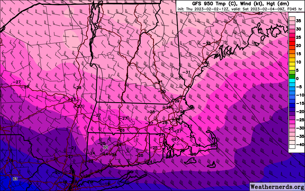
Euro looked a tad colder vs 0z. Boston pushing-10F at 12z Sat
-
It's still kinda weenie range, but the hrrr gets MHT below 0F by noon, and Boston by 6pm
-
12z gfs is 28F at MHT at 06z, but 2F by 18z. Would be one of the colder afternoons I can remember yet a high in the upper 20s
-
Yeah timing kinda screws the highs, even though Friday is real cold.
-
Soundings seem centered up around 850, opposed to a little lower a couple days ago. Little deeper mixing to moderate a bit. Friday does look dam cold, 6z gfs is sub 5F after 12z at MHT. Ruined by a midnight high in the 20s though.
-
First CT lake min showing a -24F min so far tonight. Tough to get it clear up there with upslope clouds, but when it's clear it radiates like the moon. Hopefully they can radiate a bit Sat AM.
-
Pretty nice high building down into the system in la la land on the op gfs. Shows how it can be done atleast with cold lurking over the border
-
Keep trending it a little faster and that might happen, esp western areas
-
Been a steady trend looping back a few runs. 12z gfs is 0s most of Friday now across SNH
-
Yeah the way that high crests directly over NNH early Sat night looks pretty ideal. If clear, First CT Lake would radiate like the moon before WAA tries to cap it.
-
High builds across NNE at a good time Wed morning. Should be well below 0 at the rad pits atleast.
-
12z gfs looks like the coldest gfs run so far
-
The lake by my house has completely frozen over and gone out 4 times this year. Been pretty wild. This week may atleast get the edges safe. All you need is 1-3ft of water to catch rainbow trout in the winter
-
Yeah more invested there. All I have is oaks and maples. I wouldn't want it more than a quick shot. Generally find myself enjoying warmth more these days, but those euro runs are just so anomalous.
-
Really wouldn't take much for a more glancing blow. Would be nice to be able to ice fish once locally this winter, so let's freeze some pipes
-
Nah, it's only 24hr. Bring on the 460 thicknesses
-
Pretty sure that was fake cold too. I remember radiating to like -15F that morning. Would have to radiate on the backside to challenge it.
-
Dec-Feb had like 9" here in 11-12... but we had Oct 11, then that March event was pushing double digits here. There might have been another smaller one in March too. Ended up with a bootleg 35" season.
-
Its like a high of -10 for MHT on the 4th. That would be insane
-
Definetely no moderation on that euro cold shot next week
-
Great delivery too. Below 0 highs into MA haha
-
Yeah I pulled up the PNS yesterday when I saw them post that. There were a couple 32-33" from around ash on there.
-
Yeah I guess it could end closer to normal south of MHT scrapping the rest of the month, still pretty solid given the temps.